 www.geodatenkatalog.de (S3L)
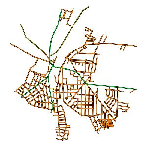
Straßennetzkarte - Gemeinde Schöneiche bei Berlin (WMS)
Die Straßennetzkarte stellt Informationen über die Straßen, Netzknoten und Abschnitte des Straßennetzes der Gemeinde zur Verfügung.
|
|
Citation proposal
. Straßennetzkarte - Gemeinde Schöneiche bei Berlin (WMS). https://gdk.gdi-de.org/geonetwork/srv/api/records/de636460-5b35-4024-b57a-192d89da1e47 |
- Identification
- Distribution
- Quality
- Spatial rep.
- Ref. system
- Content
- Portrayal
- Metadata
- Md. constraints
- Md. maintenance
- Schema info
Identification
Identification info
Service Identification (19119)
Citation
- Date ( Creation )
- 2010-10-29T00:00:00
- Purpose
- Status
- completed Completed
Point of contact
- Keywords ( Theme )
-
- infoMapAccessService
- BE/BB Schlagwortliste, Version 1.0 ( Theme )
-
- Verkehr
Legal constraints
- Use constraints
- Other restrictions
- Use constraints
- Copyright
- Other constraints
- Bereitgestellte Daten dienen ausschließlich der Information und besitzen keine Rechtsverbindlichkeit.
Legal constraints
- Access constraints
- Other restrictions
- Classification
- unclassified Unclassified
- Service Type
- view
- Service Version
- OGC:WMS 1.1.1
Extent
- Description
- Schöneiche bei Berlin
N
S
E
W
))
- Coupling Type
- tight Tight
Contains Operations
- Operation Name
- GetCapabilities
- Distributed Computing Platforms
- Web services
Distribution
- OnLine resource
- http://www.geoportal-schoeneiche-bei-berlin.de/
Metadata
Metadata
- File identifier
- de636460-5b35-4024-b57a-192d89da1e47 XML
- Metadata language
- ger German
- Character set
- utf8 UTF8
- Hierarchy level
- service Service
- Hierarchy level name
- service
- Date stamp
- 2024-06-24T15:09:56
- Metadata standard name
- ISO 19115:2003/Cor 1:2006, 19119:2005/Amd 1:2008 (AdV-Metadatenprofil)
- Metadata standard version
- 1.2.1
Point of contact
Overviews
Provided by

Views
de636460-5b35-4024-b57a-192d89da1e47
Access to the portal
Read here the full details and access to the data.
Associated resources
Not available