 My GeoNetwork catalogue
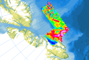
Helicopter-borne Magnetics PMAP-CASE
As part of the PMAP-CASE (Polar Margin Aeromagnetic Program - Circum-Arctic Structural Events) expeditions, two surveys were conducted in consecutive seasons in 1997 and 1998. Cooperating partners were the Department of National Defence (DND), GSC Ottawa and the Institute for Aerospace Research Ottawa (IAR-NRC). The surveys covered the areas of the northern continental margin of Greenland including the northern Nansen Land and western Johannes V. Jensen Land, as well as parts of the Lincoln Sea. The objective of the campaigns was to investigate the structures of the upper crust of the Morris Jesup Plateau and the correlation of magnetic anomalies with known structures and geologic units on land (Franklinian Basin, Kap Washington volcanics, and volcanic dyke swarms). Airborne magnetic surveys (Convair 580) were conducted with a 3 km flight line spacing, and control lines were flown every 30 km. Data were recorded at a constant flight altitude of 300 m above ground. Approximately 30000 km of line data were collected during the two expeditions, covering an area of 73000 km².
Simple
- Alternate title
-
AeromagPMAP_97_98
- Date (Publication)
- 2023-02-22
- Citation identifier
- aa329603-372d-e3ea-b613-5c047fd9f383
- Status
- Completed
-
GEMET - INSPIRE themes, version 1.0
-
-
Geologie
-
Geology
-
-
GEMET - Concepts, version 2.4
-
-
Geophysik
-
- Theme
-
-
Aerogeophysik
-
Aeromagnetik
-
Anomalien des erdmagnetischen Feldes
-
Airborne geophysics
-
helicopter-borne /fixed-wing magnetics
-
anomalies of the Earth’s magnetic field
-
- Place
-
-
Arktis
-
Arctic
-
Nordpolargebiet
-
North Polar
-
- Access constraints
- Other restrictions
- Other constraints
- Es gelten keine Zugriffsbeschränkungen
- Use constraints
- Other restrictions
- Other constraints
-
Allgemeine Geschäftsbedingungen, siehe https://www.bgr.bund.de/AGB - General terms and conditions, see https://www.bgr.bund.de/AGB_en . Die bereitgestellten Informationen sind bei Weiterverwendung wie folgt zu zitieren: Datenquelle: AeromagPMAP-CASE, (c) BGR, Hannover, 2023
- Language
- English
- Character set
- UTF8
- Topic category
-
- Geoscientific information
))
- Unique resource identifier
- EPSG:3995
- Distribution format
-
-
GeoTIFF
(
n/a
)
-
shp
(
n/a
)
-
WMS
(
OGC:WMS1.3.0
)
-
GeoTIFF
(
n/a
)
- OnLine resource
-
AeromagPMAP_97_98 (GeoTIFF)
AeromagPMAP_97_98 im Format geoTiff
- OnLine resource
- Arktisforschung der BGR
- OnLine resource
- Karte im BGR-Geoviewer
- OnLine resource
-
Flightlines (Shape)
Flightlines im Format Shape
- Hierarchy level
- Dataset
- Statement
-
The aeromagnetic data were collected by Department of National Defence (DND), GSC Ottawa, the Institute for Aerospace Research Ottawa (IAR-NRC), and BGR as part of the CASE program on the PMAP-CASE expeditions north of Greenland.
- File identifier
- e08bd240-2443-4c38-9876-2db0b35e02b7 XML
- Metadata language
- English
- Character set
- UTF8
- Parent identifier
-
Helicopter-borne Magnetics in the Arctic region
e85d6dcc-91b8-48bc-a80d-7ca0f9546cda
- Hierarchy level
- Dataset
- Hierarchy level name
-
Geophysik
- Date stamp
- 2026-01-13
- Metadata standard name
-
INSPIRE Metadata Implementing Rules: Technical Guidelines based on EN ISO 19115 and EN ISO 19119
- Metadata standard version
-
n/a
Overviews
Spatial extent
Provided by
