 My GeoNetwork catalogue
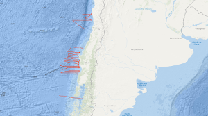
Processed seismic data of Cruise SO161 SPOC 2001
Within the frame of the comprehensive SPOC project (Subduction Processes off Chile) the SONNE cruises SO161 Leg 2 and 3 have been conducted between October 16th and November 29th, 2001, off central Chile between 28° and 44° S. In that period some 5,300 km were surveyed with multichannel seismic (MCS) reflection, magnetic, gravity, high-resolution bathymetric and echographic methods. In addition, approximately 3,900 km were surveyed with the same spectrum of methods but without MCS. The total number of 2D profiles was 48. Target was the variation of the subduction properties between the convergent oceanic Nazca and continental Southamerica plates and the different conditions that might influence the subduction process as there are: (1) age of the oceanic crust, (2) its structure and composition, (3) its sedimentary cover, (4) its thermal state, (5) the subduction angle and obliquity, and (6) the terrigenous sediment afflux from the continent. Furthermore, special focus was given to the subduction front, the subduction interface, the structure of the slope as well as to the forearc basin structure and history, and the general distribution of gas hydrate indicating bottom simulating reflectors (BSR's). The results are to be compared with previous studies of the Chilean active margin, e.g. CONDOR (SO 101 and 103) and CINCA (SO 104). The SPOC target area was subdivided into three sub-areas A,B and C. One area was chosen for a detailed survey by aid of a narrowly spaced grid and for a close link with a lot of partners. This area is characterized by a distinctly different margin type south of it is assumed. Moreover, the subducting portion of the aseismic Juan Fernandez Ridge is located in that area representing another important target of the survey. Advantageous conditions enabled the survey of an east-west profile south of Chiloé Island, providing a section through the submerged coastal Cordillera into the flooded longitudinal valley. Some results of Leg 2 and 3 are: In all areas A, B and C no subduction bulge (outer high) in the oceanic crust was visible perhaps due to the shortness of the profiles. The sedimentary cover of the oceanic crust is exceptionally thin, and the crustal thickness is generally quite "normal" with around 7 km derived from relatively weak Moho reflections. In area B a so far magnetically unmapped region was filled providing reliable ages of the oceanic crust, and suggesting that the Challenger Fracture Zone abruptly terminates west of the area of investigation. The survey in area C yielded valuable information on the trench morphology. The so far unique MCS profile south of Chiloé island shows a very wide trench and allows to extrapolate the general conditions encountered an area A southward to approximately 44° S. It can be stated that the situation is in sharp contrast to the basin structures detected by industry profiles further north in the Golfo de Corcovado.
Simple
- Alternate title
-
SO161 SPOC 2001
- Date (Creation)
- 2001-11-29
- Citation identifier
- a734d0d2-be18-aadb-01a0-a0c7f8506fcd
- Status
- Completed
-
GEMET - INSPIRE themes, version 1.0
-
-
Geologie
-
geology
-
-
GEMET - Concepts, version 2.4
-
-
geophysics
-
Geophysik
-
raw material
-
Rohstoff
-
- Theme
-
-
Marine geology
-
Meeresgeologie
-
Seismics
-
Seismik
-
Two-dimensional seismic reflection
-
zweidimensionale Reflektionsseismik
-
- Place
-
-
Southeast Pacific Ocean
-
Südost-Pazifik
-
Chile
-
- Access constraints
- Other restrictions
- Other constraints
- Es gelten keine Zugriffsbeschränkungen
- Use constraints
- Other restrictions
- Other constraints
-
Allgemeine Geschäftsbedingungen, siehe http://www.bgr.bund.de/AGB - General terms and conditions, see http://www.bgr.bund.de/AGB_en . Die bereitgestellten Informationen sind bei Weiterverwendung wie folgt zu zitieren: Datenquelle: SO161 SPOC 2001, (c) BGR, Hannover, 2018
- Spatial representation type
- Vector
- Language
- English
- Character set
- UTF8
- Topic category
-
- Geoscientific information
))
- Unique resource identifier
- EPSG:4326
- Distribution format
-
-
Shapefile
(
n/a
)
-
Shapefile
(
n/a
)
- Transfer size
- 2
- OnLine resource
-
SO161 SPOC 2001 (Shapefile)
SO161 SPOC 2001 im Format ESRI Shape
- OnLine resource
- Profile SO161-007
- OnLine resource
- Profile SO161-008
- OnLine resource
- Profile SO161-009
- OnLine resource
- Profile SO161-012
- OnLine resource
- Profile SO161-013
- OnLine resource
- Profile SO161-014
- OnLine resource
- Profile SO161-015
- OnLine resource
- Profile SO161-016
- OnLine resource
- Profile SO161-017
- OnLine resource
- Profile SO161-019
- OnLine resource
- Profile SO161-022
- OnLine resource
- Profile SO161-023
- OnLine resource
- Profile SO161-024
- OnLine resource
- Profile SO161-025
- OnLine resource
- Profile SO161-026
- OnLine resource
- Profile SO161-027
- OnLine resource
- Profile SO161-028
- OnLine resource
- Profile SO161-029
- OnLine resource
- Profile SO161-030
- OnLine resource
- Profile SO161-031
- OnLine resource
- Profile SO161-032
- OnLine resource
- Profile SO161-033
- OnLine resource
- Profile SO161-034
- OnLine resource
- Profile SO161-035
- OnLine resource
- Profile SO161-036
- OnLine resource
- Profile SO161-037
- OnLine resource
- Profile SO161-038
- OnLine resource
- Profile SO161-040
- OnLine resource
- Profile SO161-042
- OnLine resource
- Profile SO161-043
- OnLine resource
- Profile SO161-044
- OnLine resource
- Profile SO161-045
- OnLine resource
- Profile SO161-046
- OnLine resource
- Profile SO161-047
- OnLine resource
- Karte im BGR-Geoviewer
- Hierarchy level
- Dataset
Conformance result
- Date (Publication)
- 2010-12-08
- Explanation
-
siehe dazu die angegebene Durchführungsbestimmung
- Statement
-
During the period from 16th October 2001 to 29th November 2001 BGR acquired seismic lines off the Atlantic coast of South America. Lines SO161-018 and SO161-046G consist of raw data. Lines SO161-007, SO161-022, SO161-038, SO161-040 and SO161-046 consist of stacked data. Lines SO161-008, SO161-009, SO161-012, SO161-013, SO161-014, SO161-015, SO161-016, SO161-017, SO161-019, SO161-023, SO161-024, SO161-025, SO161-026, SO161-027, SO161-028, SO161-029, SO161-030, SO161-031, SO161-032, SO161-033, SO161-034, SO161-035, SO161-036, SO161-037, SO161-042, SO161-043, SO161-044, SO161-045, SO161-047 are migrated data.
- File identifier
- e4629f53-dc3b-4f7f-962f-ff16d5adcacd XML
- Metadata language
- English
- Character set
- UTF8
- Parent identifier
-
Marine Seismic Survey Profiles (MSSP)
06a73c56-06a2-40d8-b806-466222b0760d
- Hierarchy level
- Dataset
- Hierarchy level name
-
Geophysik
- Date stamp
- 2025-02-12
- Metadata standard name
-
INSPIRE Metadata Implementing Rules: Technical Guidelines based on EN ISO 19115 and EN ISO 19119
- Metadata standard version
-
n/a
Overviews
Spatial extent
Provided by
