 www.geodatenkatalog.de (S3L)
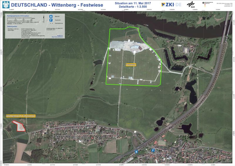
DEUTSCHLAND - Wittenberg - Detailkarte Festwiese, 2017 - P03 - Situation am 11. Mai 2017
Die Detailkarte zeigt die Festwiese am südlichen Elbufer. Eine Satellitenbildaufnahme (WorldView-4) mit einer geometrischen Auflösung von 30 cm vom 11. Mai 2017 dient als Kartenhintergrund. Im als "Festwiese" gekennzeichneten Bereich sind erste Aufbauten für die Feierlichkeiten zum Reformationsjubiläum zu sehen.
|
|
Citation proposal
. DEUTSCHLAND - Wittenberg - Detailkarte Festwiese, 2017 - P03 - Situation am 11. Mai 2017. https://gdk.gdi-de.org/geonetwork/srv/api/records/e6c8d02b-985f-5a53-bdfe-cedf647a179a |
INSPIRE
Identification
- File identifier
- e6c8d02b-985f-5a53-bdfe-cedf647a179a XML
- Hierarchy level
- Dataset
Online resource
- Protocol
- WWW:DOWNLOAD-1.0-http--download
- Protocol
- WWW:DOWNLOAD-1.0-http--download
- Protocol
- WWW:DOWNLOAD-1.0-http--download
- Protocol
- WWW:DOWNLOAD-1.0-http--download
- Protocol
- WWW:DOWNLOAD-1.0-http--download
Resource identifier
- Metadata language
- German
Encoding
Projection
Classification of data and services
- Topic category
-
- Geoscientific information
Classification of data and services
Coupled resource
Coupled resource
Classification of data and services
Coupled resource
Coupled resource
Keywords
- GEMET - INSPIRE themes, version 1.0 ( Theme )
-
- Gesundheit und Sicherheit
- ZKI-DE Produktportfolio gemäß Anlage 1 zum Rahmenvertrag zwischen BMI und DLR ( Theme )
-
- Großereignis
- Satelliten- und Luftbildinformation
Other keywords
- Keywords ( Place )
-
- Deutschland
- Wittenberg
- Keywords
-
- DLR
- EOC
- ZKI
Geographic coverage
N
S
E
W
))
Temporal reference
Temporal extent
Temporal extent
- Date ( Creation )
- 2017-05-18
Quality and validity
- Lineage
- KONFORMITÄTSERKLÄRUNG: Das vorliegende Produkt wurde im Rahmen der internen Qualitätskontrolle gemäß der ZKI-DE Qualitätskontrollcheckliste für Rapid Mapping Produkte unterzogen und erfüllt die Anforderungen des ZKI-DE Portfolios.Der genutzte Analyseansatz wurde unter vergleichbaren Rahmenbedingungen validiert. Die thematische Genauigkeit dieses Produktes wird als hoch eingeschätzt. Bereiche mit reduzierter Genauigkeit sind im Kartenprodukt gekennzeichnet. Datenquellen: WorldView-4 (30 cm) © 2017 Digital Globe, Inc., Vektordaten © GeoBasis-DE / BKG 2017 (www.bgk.bund.de), OpenStreetMap Mitwirkende 2017, ZKI/DLR 2017, basierend auf Informationen des Landesverwaltungsamtes Sachsen-Anhalt
- Denominator
- 3500
- Distance
- 0.3 m
Conformity
Conformity
Conformity
Conformity
Conformity
Conformity
Restrictions on access and use
- Use limitation
- Dieses Produkt ist für eine Darstellung in DIN A1 optimiert.
- Access constraints
- Lizenz, Nutzungsbeschränkungen und Zitierhinweise für ZKI Produkte (http://s.dlr.de/vz82) gemäß Rahmenvertrag zwischen dem Bundesministerium des Innern (BMI) und dem Deutschen Zentrum für Luft- und Raumfahrt (DLR)
- Access constraints
- keine Zugriffsbeschränkungen
Restrictions on access and use
Responsible organization (s)
Contact for the resource
- Organisation name
- Deutsches Zentrum für Luft- und Raumfahrt (DLR)
- zki-am@dlr.de
Responsible organization (s)
Contact for the resource
- Organisation name
- Deutsches Zentrum für Luft- und Raumfahrt (DLR)
- zki-am@dlr.de
Metadata information
Contact for the metadata
- Organisation name
- Deutsches Zentrum für Luft- und Raumfahrt (DLR)
- zki-am@dlr.de
- Date stamp
- 2024-06-20T13:12:54
- Metadata language
- German
- Character set
- UTF8
SDS
Conformance class 1: invocable
Access Point URL
Endpoint URL
Technical specification
Conformance class 2: interoperable
Coordinate reference system
Quality of Service
Access constraints
Limitation
Use constraints
Limitation
Responsible custodian
Contact for the resource
Conformance class 3: harmonized
Overviews
thumbnail
large_thumbnail
Provided by

Views
e6c8d02b-985f-5a53-bdfe-cedf647a179a
Access to the portal
Read here the full details and access to the data.
Associated resources
Not available