 www.geodatenkatalog.de (S1L)
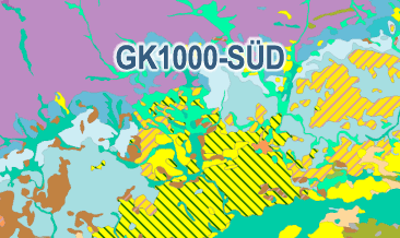
Geological Map of Southern Germany 1:1,000,000 – (GK1000-SÜD)
The Geological Map of Southern Germany 1:1,000,000 (GK1000-SÜD) was compiled as part of the BGR project ‘AGNES’ (Automated generalisation / Derivation of geological spatial data). With the help of the modified FME-based AutoGen workflow - developed at the State Office for Geology, Raw Materials and Mining in Baden-Württemberg (LGRB) - the GK1000-SÜD was derived on the basis of current areal data at a detail scale of 1:25,000 / 1:50,000 from the SGD of Bavaria and Baden-Württemberg, which were made available to the BGR as part of the ‘ConSent’ project. The GK1000-SÜD contains a lithostratigraphy layer with the corresponding legend. The legend is mainly based on the Superordinate General Legend (SGL) developed in the ‘ConSent‘ project with individual additions and changes according to the lists of terms in the ‘Guidelines for the Compilation of Geological Maps‘. The GK1000-SÜD does not currently contain any tectonic line elements or ice margins. The integration of the current tectonic line elements and the current ice margins from the SGD is to be carried out as part of a further project.
|
|
Citation proposal
(2024) . Geological Map of Southern Germany 1:1,000,000 – (GK1000-SÜD). https://gdk.gdi-de.org/geonetwork/srv/api/records/e75117d2-083e-4e13-9d04-9f2a17593084 |
INSPIRE
Identification
- File identifier
- e75117d2-083e-4e13-9d04-9f2a17593084 XML
- Hierarchy level
- dataset Dataset
Online resource
Resource identifier
- Metadata language
- ger German
- Spatial representation type
- Vector
Encoding
- Format
- WMS
- Version
- 1.3.0
Projection
Classification of data and services
- Topic category
-
- Geoscientific information
Classification of data and services
Coupled resource
Coupled resource
Classification of data and services
Coupled resource
Coupled resource
Keywords
- GEMET - INSPIRE themes, version 1.0 ( Theme )
-
- Geologie
- Geology
Other keywords
- Keywords ( Theme )
-
- Geogenese
- Lithostratigraphie
- Oberflächengeologie
- Petrographie
- Stratigraphie
- opendata
- Keywords ( Place )
-
- Deutschland
Geographic coverage
N
S
E
W
))
Temporal reference
Temporal extent
Temporal extent
- Date ( Publication )
- 2024-07-29
Quality and validity
- Lineage
- Die Geologische Karte von Süddeutschland 1:1.000.000 (GK1000-SÜD) wurde im Rahmen des BGR-Projektes „AGNES“ (Automatisierte Generalisierung / Ableitung von geologischen Flächen- und Raumdaten) erstellt.
- Denominator
- 1000000
Conformity
Conformity
Conformity
Conformity
Conformity
Conformity
- Explanation
- siehe dazu die angegebene Durchführungsbestimmung
Restrictions on access and use
- Access constraints
- Dieser Datensatz kann gemäß der "Nutzungsbestimmungen für die Bereitstellung von Geodaten des Bundes" (https://sg.geodatenzentrum.de/web_public/gdz/lizenz/geonutzv.pdf) genutzt werden.
- Access constraints
- {"id": "geoNutz/20130319", "name": "Nutzungsbestimmungen für die Bereitstellung von Geodaten des Bundes", "url": "https://sg.geodatenzentrum.de/web_public/gdz/lizenz/geonutzv.pdf", "quelle": "Bundesanstalt für Geowissenschaften und Rohstoffe (BGR)"}
Restrictions on access and use
Responsible organization (s)
Contact for the resource
- Organisation name
- Bundesanstalt für Geowissenschaften und Rohstoffe (BGR)
- geologie.daten@bgr.de
Responsible organization (s)
Contact for the resource
- Organisation name
- Bundesanstalt für Geowissenschaften und Rohstoffe (BGR)
- geologie.daten@bgr.de
Metadata information
Contact for the metadata
- Organisation name
- Bundesanstalt für Geowissenschaften und Rohstoffe (BGR)
- Date stamp
- 2024-10-08
- Metadata language
- German
- Character set
- utf8 UTF8
SDS
Conformance class 1: invocable
Access Point URL
Endpoint URL
Technical specification
Conformance class 2: interoperable
Coordinate reference system
Quality of Service
Access constraints
Limitation
Use constraints
Limitation
Responsible custodian
Contact for the resource
Conformance class 3: harmonized
Overviews
Provided by

Views
e75117d2-083e-4e13-9d04-9f2a17593084
Access to the portal
Read here the full details and access to the data.
Associated resources
Not available