 www.geodatenkatalog.de (S3L)
Postleitzahlen
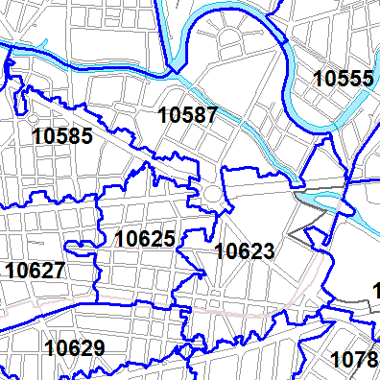
Der Datenbestand zeigt die Postleitzahlgebiete des RBS (Regionales Bezugssystem Berlin). Die Geometrien werden aus den PLZ der Deutschen Post für jede Berliner Adresse erstellt und gleichzeitig anhand der entsprechenden Grundstücksgrenzen aus der Karte von Berlin 1:5000 (K5) digitalisiert. Großflächige Entscheidungsfreiräume bleiben in Gebieten ohne Adressen (Wälder, Grünflächen etc.).
|
|
Citation proposal
(2025) . Postleitzahlen. https://gdk.gdi-de.org/geonetwork/srv/api/records/e866ac77-5d1b-33a4-b8e9-b1d20692a72b |
- Identification
- Distribution
- Quality
- Spatial rep.
- Ref. system
- Content
- Portrayal
- Metadata
- Md. constraints
- Md. maintenance
- Schema info
Identification
Identification info
Service Identification (19119)
Citation
- Date ( Creation )
- 2019-10-01
- Date ( Publication )
- 2025-11-13
- Date ( Revision )
- 2025-09-15
- Presentation form
- Digital map
Point of contact
- Maintenance and update frequency
- Biannually
- Keywords ( Theme )
-
- open data
- opendata
- Karten
- Sachdaten
- Geodaten
- Berlin
- PLZ
- RBS-PLZ
- Postleitzahlen
- RBS
- Amt für Statistik Berlin Brandenburg
- Regionales Bezugssystem Berlin
- AfS
- Räumlicher Anwendungsbereich ( Theme )
- Keywords
-
- infoMapAccessService
Legal constraints
- Access constraints
- Other restrictions
Legal constraints
- Use constraints
- Other restrictions
- Other constraints
- Der Datenbestand wird unter der Lizenz CC-BY-3.0-Namensnennung veröffentlicht (vgl. https://creativecommons.org/licenses/by/3.0/de/ ). Als Urheber ist dabei zu nennen: Amt für Statistik Berlin-Brandenburg
- Other constraints
- {"id":"cc-by-de/3.0","name":"Creative Commons - Namensnennung 3.0 Deutschland","url":"https://creativecommons.org/licenses/by/3.0/de/","quelle":"Amt für Statistik Berlin-Brandenburg"}
- Service Type
- view
- Service Version
- OGC:WMS 1.0.0
- Service Version
- OGC:WMS 1.1.0
- Service Version
- OGC:WMS 1.1.1
- Service Version
- OGC:WMS 1.3.0
Extent
N
S
E
W
))
Geographic description
- Extent type code
- true
- Geographic identifier
- 110000000000
- Coupling Type
- Tight
Contains Operations
- Operation Name
- GetCapabilities
- Distributed Computing Platforms
- Web services
- Connect Point
- https://gdi.berlin.de/services/wms/postleitzahlen
- Operates On
Distribution
Distribution
- Distribution format
-
-
Text/HTML
(4.01 )
- Specification
- Keine Angabe
-
Text/HTML
(4.01 )
- OnLine resource
-
Darstellungsdienst - Postleitzahlen (WMS)
Darstellungsdienst - Postleitzahlen (WMS)
- OnLine resource
-
Darstellung der Karte im Geoportal Berlin
Darstellung der Karte im Geoportal Berlin
Quality
Scope
- Hierarchy level
- Service
- Other
- Dienst
Ref. system
- Reference system identifier
- http://www.opengis.net/def/crs/EPSG/0/25833
Metadata
Metadata
- File identifier
- e866ac77-5d1b-33a4-b8e9-b1d20692a72b XML
- Metadata language
- German
- Character set
- UTF8
- Hierarchy level
- Service
- Hierarchy level name
- Postleitzahlen Dienst
- Date stamp
- 2025-12-01T09:58:56.310151947Z
- Metadata standard name
- ISO 19115/19119 - BE
- Metadata standard version
- 1.0.0
Point of contact
Overviews
Vorschaubild
Legende
Provided by

Views
e866ac77-5d1b-33a4-b8e9-b1d20692a72b
Access to the portal
Read here the full details and access to the data.
Associated resources
Not available