 www.geodatenkatalog.de (S1L)
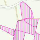
Ökoflächenkataster (Ankauf)
Das ÖFK 2020 (Ökoflächenkataster) ist ein Verzeichnis ökologisch bedeutsamer Flächen. Darin aufgenommen werden für den Naturschutz angekaufte bzw. gepachtete Flächen, Ausgleichs- und Ersatzflächen gemäß der naturschutzrechtlichen und der baurechtlichen Eingriffsregelung, Landschaftspflegeflächen der ländlichen Entwicklung (Flurb) und Ökokontoflächen.
Die Daten des Ökoflächenkatasters werden auf Grundlage der digitalen Flurkarte erfasst. Die unterschiedlichen Flächentypen werden verschiedenfarbig dargestellt. Ankaufsflächen: rosa
|
|
Citation proposal
(2023) . Ökoflächenkataster (Ankauf). https://gdk.gdi-de.org/geonetwork/srv/api/records/e99c8bfb-dd42-495f-8950-929fba7f9941 |
INSPIRE
Identification
- File identifier
- e99c8bfb-dd42-495f-8950-929fba7f9941 XML
- Hierarchy level
- dataset Dataset
Online resource
Resource identifier
- Metadata language
- German
- Spatial representation type
- Vector
Encoding
- Format
- Shapefile
Projection
Classification of data and services
- Topic category
-
- Environment
Classification of data and services
Coupled resource
Coupled resource
Classification of data and services
Coupled resource
Coupled resource
Keywords
Other keywords
- Keywords
-
- gdiby
- Ankauf
- ÖFK 2020
- Ökoflächenkataster
- Ökokonto
- UmweltAtlas
- opendata
- Keywords ( Theme )
-
- ENVI
Geographic coverage
N
S
E
W
))
Temporal reference
Temporal extent
Temporal extent
- Date ( Publication )
- 2023-03-31T00:00:00.000+02:00
Quality and validity
- Lineage
- Die Daten des Ökoflächenkatasters werden auf Grundlage der digitalen Flurkarte erfasst.
Conformity
Conformity
Conformity
Conformity
Conformity
Conformity
Restrictions on access and use
- Access constraints
- Creative Commons Namensnennung 4.0 International (CC BY 4.0); Datenquelle: Bayerisches Landesamt für Umwelt, www.lfu.bayern.de; Die Nutzung von Daten über Dienste ist geldleistungsfrei. Bei Bezug von Daten über die Datenstelle des LfU (nur Daten, die nicht über Dienste verfügbar sind) wird eine Bereitstellungsgebühr erhoben, die sich an der Umweltgebührenordnung orientiert.
- Access constraints
- {"id":"cc-by/4.0","name":"Creative Commons Namensnennung 4.0 International (CC BY 4.0)","url":"https://creativecommons.org/licenses/by/4.0/deed.de","quelle":"Bayerisches Landesamt für Umwelt, www.lfu.bayern.de"}
Restrictions on access and use
Responsible organization (s)
Contact for the resource
- Organisation name
- Bayerisches Landesamt für Umwelt
- Organisation name
- Bayerisches Landesamt für Umwelt
Responsible organization (s)
Contact for the resource
- Organisation name
- Bayerisches Landesamt für Umwelt
- Organisation name
- Bayerisches Landesamt für Umwelt
Metadata information
Contact for the metadata
- Organisation name
- Bayerisches Landesamt für Umwelt
- Date stamp
- 2024-06-19
- Metadata language
- German
- Character set
- UTF8
SDS
Conformance class 1: invocable
Access Point URL
Endpoint URL
Technical specification
Conformance class 2: interoperable
Coordinate reference system
Quality of Service
Access constraints
Limitation
Use constraints
Limitation
Responsible custodian
Contact for the resource
Conformance class 3: harmonized
Overviews
Provided by

Views
e99c8bfb-dd42-495f-8950-929fba7f9941
Access to the portal
Read here the full details and access to the data.
Associated resources
Not available