 My GeoNetwork catalogue
Processed seismic data of Cruise ANT-IV/3 1986
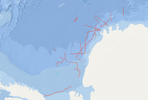
On the F.S. POLARSTERN cruise ANT-IV/3 (6th December, 1985 - 13th March, 1986) multichannel seismic measurements were carried out in parallel with magnetic and gravimetric measurements on 33 lines with a total length of 6,263 km. 3,350 km of the multichannel seismic lines have been processed aboard. The geophysical studies were designed to investigate the structure and geological development of the Weddell Sea continental margin from meridians zero to 60°W, and to define suitable and safe drilling locations for Leg 113 of the Ocean Drilling Program. The main results of the geophysical studies are: (1) The discovery of an approximately N50°E trending failed drift basin, following the trend of a negative magnetic anomaly and a positive gravity anomaly. (2) The discovery of two extensive wedge-shaped and symmetric basement units around a failed drift basin between longitudes 40°W and 20°W. The seismic characteristics, i.e. seismic velocities of 4 km/s and an internally divergent pattern of reflectors suggest that both wedges are formed from extrusive/intrusive volcanic rocks. (3) The confirmation of a major plate tectonic boundary trending approximately N80°E to N60°E, i.e. the EXPLORA-ANDENES escarpment. (4) The confirmation of a glaciogenic progradational wedge beneath the shelf of the Weddell Sea Embayment, made up of several thousand metres of sediments. (5) The definition of 13 suitable and safe drilling locations for ODP-Leg 113.
INSPIRE
Identification
- File identifier
- ea39c67d-1539-4ace-8669-e294c71ae54f XML
- Hierarchy level
- Dataset
Online resource
Resource identifier
- code
-
1692894b-6270-2a57-cccb-13a301e91531
- Metadata language
- English
- Spatial representation type
- Vector
Encoding
- Format
-
Shapefile
- Version
-
n/a
Projection
- code
- EPSG:4326
Classification of data and services
- Topic category
-
- Geoscientific information
Classification of data and services
Coupled resource
Coupled resource
Classification of data and services
Coupled resource
Coupled resource
Keywords
-
GEMET - INSPIRE themes, version 1.0
-
-
Geologie
-
geology
-
-
GEMET - Concepts, version 2.4
-
-
geophysics
-
Geophysik
-
raw material
-
Rohstoff
-
Other keywords
- Theme
-
-
Marine geology
-
Meeresgeologie
-
Seismics
-
Seismik
-
Two-dimensional seismic reflection
-
zweidimensionale Reflektionsseismik
-
- Place
-
-
Weddell Sea
-
Weddell-Meer
-
Geographic coverage
))
Temporal reference
Temporal extent
Temporal extent
- Date (Creation)
- 1986-03-13
Quality and validity
- Lineage
-
During the period from 6th December 1985 to 13th March 1986 BGR acquired seismic lines in the Weddell Sea. The lines ANT4-11A, ANT4-20 and ANT4-24 consist of raw data. The lines ANT4-10, ANT4-11, ANT4-16, ANT4-23, ANT4-26 and ANT4-30 are stacked data. The lines ANT4-01, ANT4-02, ANT4-03, ANT4-04, ANT4-05, ANT4-06, ANT4-07, ANT4-08, ANT4-09, ANT4-12, ANT4-13, ANT4-14, ANT4-15, ANT4-17, ANT4-18, ANT4-19, ANT4-21, ANT4-22, ANT4-25, ANT4-27, ANT4-28, ANT4-29, ANT4-31, ANT4-32 and ANT4-33 are migrated data.
Conformity
Conformity
Conformity
Conformity
Conformity
Conformity
- Explanation
-
siehe dazu die angegebene Durchführungsbestimmung
Restrictions on access and use
- Access constraints
- Es gelten keine Zugriffsbeschränkungen
- Access constraints
-
Allgemeine Geschäftsbedingungen, siehe http://www.bgr.bund.de/AGB - General terms and conditions, see http://www.bgr.bund.de/AGB_en . Die bereitgestellten Informationen sind bei Weiterverwendung wie folgt zu zitieren: Datenquelle: ANT-IV/3 1986, (c) BGR, Hannover, 2019
Responsible organization (s)
Contact for the resource
- Organisation name
-
Federal Institute for Geosciences and Natural Resources
Responsible organization (s)
Contact for the resource
- Organisation name
-
Federal Institute for Geosciences and Natural Resources
Metadata information
Contact for the metadata
- Organisation name
-
Bundesanstalt für Geowissenschaften und Rohstoffe (BGR)
- Date stamp
- 2023-11-14
- Metadata language
- English
- Character set
- UTF8
SDS
Conformance class 1: invocable
Access Point URL
Endpoint URL
Technical specification
Conformance class 2: interoperable
Access constraints
Limitation
Use constraints
Limitation
Responsible custodian
Contact for the resource
Overviews
Spatial extent
Provided by
