 www.geodatenkatalog.de (S3L)
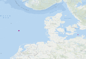
OBS stations of the GEOSTOR project in the German Bight and in the German Baltic Sea
The dataset includes the locations of OBS stations (Ocean Bottom Seismometers) operated in the German Bight during cruise MSM100 with R.V. Maria S. Merian. The time interval from 13.05.2021 to 15.05.2021 has been analysed in a phase without airgun operation for passive recording with 4.5 Hz geophones. Furthermore, the dataset contains locations of 3 broadband OBS systems which were operated during an experiment at the Darss ramp in the German Baltic Sea. The records were analysed in the time interval 23.01.2018 to 01.04.2018.
|
|
Citation proposal
(2024) . OBS stations of the GEOSTOR project in the German Bight and in the German Baltic Sea. https://gdk.gdi-de.org/geonetwork/srv/api/records/ead57417-73ac-43ae-a501-614913d5b732 |
INSPIRE
Identification
- File identifier
- ead57417-73ac-43ae-a501-614913d5b732 XML
- Hierarchy level
- Dataset
Online resource
Resource identifier
- Metadata language
- English
- Spatial representation type
- Vector
Encoding
- Format
- online
- Version
- n/a
- Format
- ESRI Shape
- Version
- n/a
Projection
Classification of data and services
- Topic category
-
- Geoscientific information
Classification of data and services
Coupled resource
Coupled resource
Classification of data and services
Coupled resource
Coupled resource
Keywords
- GEMET - INSPIRE themes, version 1.0 ( Theme )
-
- Geology
- Geologie
Other keywords
- Keywords ( Theme )
-
- geophysics
- Geophysik
- CO2-Speicherung
- CO2 Storage
- Marine geology
- Meeresgeologie
- Seismics
- Seismik
- Ozeanboden-Seismometer
- Ocean Bottom Seismometer
- GeolDG
- Keywords ( Place )
-
- Ostsee
- Baltic Sea
- German Bight
- Deutsche Bucht
Geographic coverage
N
S
E
W
))
Temporal reference
Temporal extent
Temporal extent
- Date ( Publication )
- 2024-07-31
Quality and validity
- Lineage
- During the period from the 13th May to the 15th May 2021, BGR has operated Ocean Bottom Seismometers (OBS stations) in the German Bight during the project GeoBasis3D. In a phase without airgun operation for passive recording with 4.5 Hz geophones, the data were analysed. Furthermore, experiments with 3 broadband OBS systems have been made at the Darss ramp in the German Baltic Sea. The recorded data were analysed in the time interval from 23.01.2018 to 01.04.2018.
Conformity
Conformity
Conformity
Conformity
Conformity
Conformity
- Explanation
- siehe dazu die angegebene Durchführungsbestimmung
Restrictions on access and use
- Access constraints
- { "id": "dl-by-de/2.0", "name": "Datenlizenz Deutschland Namensnennung 2.0", "url": "https://www.govdata.de/dl-de/by-2-0", "quelle": "GEOSTOR-OBS" }
Restrictions on access and use
Responsible organization (s)
Contact for the resource
- Organisation name
- Bundesanstalt für Geowissenschaften und Rohstoffe (BGR)
- Marine_Seismik@bgr.de
Responsible organization (s)
Contact for the resource
- Organisation name
- Bundesanstalt für Geowissenschaften und Rohstoffe (BGR)
- Marine_Seismik@bgr.de
Metadata information
Contact for the metadata
- Organisation name
- Bundesanstalt für Geowissenschaften und Rohstoffe (BGR)
- Date stamp
- 2024-08-07
- Metadata language
- English
- Character set
- UTF8
SDS
Conformance class 1: invocable
Access Point URL
Endpoint URL
Technical specification
Conformance class 2: interoperable
Coordinate reference system
Quality of Service
Access constraints
Limitation
Use constraints
Limitation
Responsible custodian
Contact for the resource
Conformance class 3: harmonized
Overviews
Provided by

Views
ead57417-73ac-43ae-a501-614913d5b732
Access to the portal
Read here the full details and access to the data.
Associated resources
Not available