 My GeoNetwork catalogue
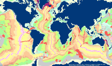
General Global Map of Seafloor Bedrock Geology (seafloorgeol)
The General Global Map of Seafloor Bedrock Geology (seafloorgeol) shows the global distribution of seafloor bedrock, the boundaries of the continental shelf and continental slope, the axes of the oceanic ridges and other marine geological features. Sedimentary deposits are not shown. The map is based on extracts from Bouysse et al. (2010) © CGMW, and Bryan & Ernst (2008) using Esri Basemap, HERE, Garmin, FAO, NOAA, USGS, © OpenStreetMap contributors and the GIS User Community.
INSPIRE
Identification
- File identifier
- eced4cf0-b4f4-48bb-8f82-37c0f5a33311 XML
- Hierarchy level
- Dataset
Online resource
Resource identifier
- code
-
81cdde56-db4e-a35a-ff3f-dce6053cd3ba
- Metadata language
- Deutsch
- Spatial representation type
- Vector
Encoding
- Format
-
WMS
- Version
-
1.3.0
Projection
- code
- EPSG:3857
Classification of data and services
- Topic category
-
- Geoscientific information
Classification of data and services
Coupled resource
Coupled resource
Classification of data and services
Coupled resource
Coupled resource
Keywords
-
GEMET - INSPIRE themes, version 1.0
-
-
Geologie
-
Geology
-
Other keywords
- Place
-
-
world
-
- Theme
-
-
seafloor geology
-
off-shore
-
bedrock
-
map
-
GeolDG
-
Geographic coverage
))
Temporal reference
Temporal extent
Temporal extent
- Date (Publication)
- 2022-05-18
Quality and validity
- Lineage
-
Map based on extracts from Bouysse et al. (2010) © CGMW, and Bryan & Ernst (2008), using the Esri Basemap, HERE, Garmin, FAO, NOAA, USGS, © OpenStreetMap contributors and the GIS User Community Bouysse, P. et al (2010): Geological Map of the World. Commission of the Bryan, S. E. and Ernst R. E., 2008. Revised definition of Large Igneous Provinces (LIPs), Elsevier, Earth Science Review 86
- Denominator
- 70000000
Conformity
Conformity
Conformity
Conformity
Conformity
Conformity
- Explanation
-
siehe dazu die angegebene Durchführungsbestimmung
Restrictions on access and use
- Access constraints
- Es gelten keine Zugriffsbeschränkungen
- Access constraints
-
Allgemeine Geschäftsbedingungen, s. https://www.bgr.bund.de/agb - General Terms and Conditions, s. https://www.bgr.bund.de/agb_en
Responsible organization (s)
Contact for the resource
- Organisation name
-
Bundesanstalt für Geowissenschaften und Rohstoffe
Responsible organization (s)
Contact for the resource
- Organisation name
-
Bundesanstalt für Geowissenschaften und Rohstoffe
Metadata information
Contact for the metadata
- Organisation name
-
Bundesanstalt für Geowissenschaften und Rohstoffe (BGR)
- Date stamp
- 2025-01-20
- Metadata language
- English
- Character set
- UTF8
SDS
Conformance class 1: invocable
Access Point URL
Endpoint URL
Technical specification
Conformance class 2: interoperable
Access constraints
Limitation
Use constraints
Limitation
Responsible custodian
Contact for the resource
Overviews
Spatial extent
Provided by
