 www.geodatenkatalog.de (S1L)
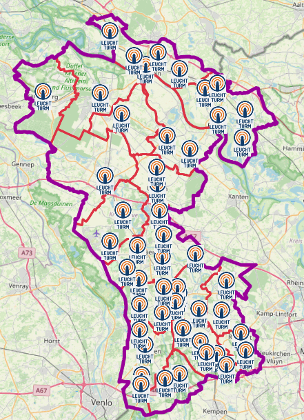
Leuchttürme Kreis Kleve
Leuchttürme in den Städten und Gemeinden sind mit Notstrom versorgt. Sie dienen als zentrale Anlaufstellen für Bürgerinnen und Bürger in Not oder mit Informationsbedarf.
Es gibt dort Informationen für die Bevölkerung. Darüber hinaus fungieren die Leuchttürme als Verbindungsstellen zwischen den hilfesuchenden Bürgerinnen und Bürgern und den Einsatzstäben der Kommunen und des Kreises Kleve.
Sie übernehmen auch die Funktion von Notrufstellen.
Es handelt sich um keine dauerhafte Einrichtungen und werden von den Städten und Gemeinden bei Bedarf im Fall eines Notfalls besetzt.
|
|
Citation proposal
(2023) . Leuchttürme Kreis Kleve. Kreis Kleve - Der Landrat https://gdk.gdi-de.org/geonetwork/srv/api/records/ed871993-ac5c-4d6f-be6e-f74d7680946d |
- Identification
- Distribution
- Quality
- Spatial rep.
- Ref. system
- Content
- Portrayal
- Metadata
- Md. constraints
- Md. maintenance
- Schema info
Identification
Data identification
Citation
- Date ( Publication )
- 2023-06-30T00:00:00.000+02:00
Publisher
Point of contact
Kreis Kleve - Abt. Kataster- und Vermessung - Produktbereich GeoInformation (GIS)
Nassauerallee 15-23
Kleve
Nordrhein-Westfalen
47533
DEU
Maintenance information
- Maintenance and update frequency
- As needed
- Update scope
- Dataset
- Keywords
-
- Kreis Kleve
- Bedburg-Hau
- Emmerich am Rhein
- Emmerich
- Geldern
- Goch
- Issum
- Kalkar
- Kerken
- Wallfahrtsstadt Kevelaer
- Kevelaer
- Kranenburg
- Kleve
- Rees
- Rheurdt
- Straelen
- Uedem
- Wachtendonk
- Weeze
- NW
- NRW
- Nordrhein-Westfalen
- Notfallanlaufstellen
- Notfall
- Leuchttürme
- Leuchtturm
- Blackout
- 05154
- Anlaufstelle
- Open Data
- opendata
- Keywords ( Theme )
-
- SOCI
Legal constraints
- Use constraints
- Other restrictions
- Other constraints
- Open Data Commons Open Database License (ODbL)
- Other constraints
- {"id":"odbl","name":"Open Data Commons Open Database License (ODbL)","url":"https://www.opendefinition.org/licenses/odc-odbl","quelle":""}
- Other constraints
- © OpenStreetMap-Mitwirkende
- Other constraints
- Quellenvermerk: https://www.openstreetmap.org/copyright
Legal constraints
- Access constraints
- otherRestrictions Other restrictions
- Metadata language
- German
- Topic category
-
- Health
- Society
- Utilities communication
Extent
Bounding Polygon
- Extent type code
- true
Geographic description
- Extent type code
- true
- Geographic identifier
- Kreis Kleve, Nordrhein-Westfalen, Deutschland (administrative) (05154)
N
S
E
W
))
Distribution
Distribution
- Distribution format
-
- ()
- OnLine resource
- WFS Notfallanlaufstellen KLE KR VIE WES
- OnLine resource
- WMS Notfallanlaufstellen KLE KR VIE WES
- OnLine resource
- WMS Notfallanlaufstellen KLE KR VIE WES
- OnLine resource
- WFS Notfallanlaufstellen KLE KR VIE WES
Quality
Data quality
- Hierarchy level
- Dataset
- Statement
- von kommunaler Instanz gemeldet
Metadata
Metadata
- File identifier
- ed871993-ac5c-4d6f-be6e-f74d7680946d XML
- Metadata language
- German
- Character set
- UTF8
- Parent identifier
- e262b787-2bf0-4237-8097-e6637918c73a
- Hierarchy level
- dataset Dataset
- Date stamp
- 2025-07-02
- Metadata standard name
- ISO19115
- Metadata standard version
- 2003/Cor.1:2006
Point of contact
Kreis Kleve - Abt. Kataster- und Vermessung - Produktbereich GeoInformation (GIS)
Nassauerallee 15-23
Kleve
Nordrhein-Westfalen
47533
DEU
Overviews
Leuchttürme im Kreis Kleve
Provided by

Views
ed871993-ac5c-4d6f-be6e-f74d7680946d
Access to the portal
Read here the full details and access to the data.
Associated resources
Not available