 My GeoNetwork catalogue
Processed seismic data of Cruise BGR84 1984
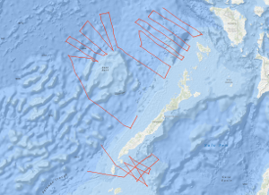
In the southwestern part of the Sulu Sea and in the southeastern part of the South China Sea, between NW Palawan and the northwestern part of the Reed Bank the Federal Institute for Geosciences and Natural Resources (BGR), Hannover carried out the geophysical survey BGR84 from 11th October, 1984 to 23rd November, 1984. This work was done in close cooperation with the Bureau of Mines and Geosciences (BMG), Manila, using the German seismic vessel EXPLORA chartered from PRAKLA-SEISMOS GmbH, Hannover. Multichannel reflection seismic measurements were carried out on 40 lines with a total length of 4,467 km simultaneously with magnetic measurements on 19 lines with a total length of 3,047 km. The Oligocene to lower Miocene Nido-carbonates of the South China Sea that have been proven during the SONNE cruises SO-23 and SO-27 beneath the allochthonous and chaotically deformed complex which was overthrusted from the Sulu Sea terrane, could be correlated up to the Balabac Straits. The three major unconformities of the Sulu Sea, unconformity A (Early Pliocene), unconformity B (mid Middle Miocene) and unconformity C (lower Middle Miocene) have been correlated over extensive areas by tying into the Sulu Sea well Coral-1. In the Sulu Sea reflection horizon C forms the top of a chaotic bedded rock complex and presumably represents an equivalent to the unconformity "Red" of the South China Sea, in the west of Palawan. There, the unconformity "Red" forms the surface of a highly deformed rock complex which has been interpreted as an allochthonous mass accumulation (HINZ, 1983; HINZ & SCHLÜTER, 1985). It is assumed that pronounced magnetic anomalies, approximately 140 - 160 km off NW Palawan as well as a change in the reflection seismic pattern of the acoustic basement, associated with diapiric structures which are interpreted as intrusions represent the ocean-continent boundary in this part of the South China Sea. In the Reed Bank area the basement type which is interpreted as continental crust (transitional crust?) extends as far as 160 km to the northwest, towards the South China Sea Basin. The northern part of the Reed Bank is characterized by intense downfaulting and rotated fault blocks with reef complexes ontop. In contrast to results from the Dangerous Grounds of the previous SONNE cruises, the deeper lying coherent reflections could be recognized in the monitor records off the northwestern Reed Bank area. It might be that these parts of the Reed Bank block consists of metamorphized and/or highly consolidated rocks of pre-Tertiary age which originally formed part of the Chinese back country, and which was effected by previous orogenies prior to the rifting of the proto-China continental margin.
Simple
- Alternate title
-
BGR84 1984
- Date (Creation)
- 1984-11-23
- Citation identifier
- c627e620-93bd-93a4-44ca-7807d83d87cc
- Status
- Completed
-
GEMET - INSPIRE themes, version 1.0
-
-
Geologie
-
geology
-
-
GEMET - Concepts, version 2.4
-
-
geophysics
-
Geophysik
-
raw material
-
Rohstoff
-
- Theme
-
-
Marine geology
-
Meeresgeologie
-
Seismics
-
Seismik
-
Two-dimensional seismic reflection
-
zweidimensionale Reflektionsseismik
-
- Place
-
-
South China Sea
-
Südchinesisches Meer
-
Sulu Sea
-
Sulu-See
-
Palawan
-
Reed Bank
-
- Access constraints
- Other restrictions
- Other constraints
- Es gelten keine Zugriffsbeschränkungen
- Use constraints
- Other restrictions
- Other constraints
-
Allgemeine Geschäftsbedingungen, siehe http://www.bgr.bund.de/AGB - General terms and conditions, see http://www.bgr.bund.de/AGB_en . Die bereitgestellten Informationen sind bei Weiterverwendung wie folgt zu zitieren: Datenquelle: BGR84 1984, (c) BGR, Hannover, 2019
- Spatial representation type
- Vector
- Language
- English
- Character set
- UTF8
- Topic category
-
- Geoscientific information
))
- Unique resource identifier
- EPSG:4326
- Distribution format
-
-
Shapefile
(
n/a
)
-
Shapefile
(
n/a
)
- Transfer size
- 2
- OnLine resource
-
BGR84 1984 (Shapefile)
BGR84 1984 im Format ESRI Shape
- OnLine resource
- Profile BGR84-01
- OnLine resource
- Profile BGR84-02
- OnLine resource
- Profile BGR84-03
- OnLine resource
- Profile BGR84-04
- OnLine resource
- Profile BGR84-05
- OnLine resource
- Profile BGR84-06
- OnLine resource
- Profile BGR84-07
- OnLine resource
- Profile BGR84-08
- OnLine resource
- Profile BGR84-09
- OnLine resource
- Profile BGR84-10
- OnLine resource
- Profile BGR84-101
- OnLine resource
- Profile BGR84-102
- OnLine resource
- Profile BGR84-103
- OnLine resource
- Profile BGR84-104
- OnLine resource
- Profile BGR84-105
- OnLine resource
- Profile BGR84-106
- OnLine resource
- Profile BGR84-107
- OnLine resource
- Profile BGR84-109
- OnLine resource
- Profile BGR84-111
- OnLine resource
- Profile BGR84-112
- OnLine resource
- Profile BGR84-113
- OnLine resource
- Profile BGR84-115
- OnLine resource
- Profile BGR84-116
- OnLine resource
- Profile BGR84-118
- OnLine resource
- Profile BGR84-119
- OnLine resource
- Profile BGR84-120
- OnLine resource
- Profile BGR84-121
- OnLine resource
- Profile BGR84-121B
- OnLine resource
- Profile BGR84-123
- OnLine resource
- Profile BGR84-124
- OnLine resource
- Profile BGR84-125
- OnLine resource
- Profile BGR84-126
- OnLine resource
- Profile BGR84-129
- OnLine resource
- Karte im BGR-Geoviewer
- Hierarchy level
- Dataset
Conformance result
- Date (Publication)
- 2010-12-08
- Explanation
-
siehe dazu die angegebene Durchführungsbestimmung
- Statement
-
In the period from 11th October to 23rd November 1984 BGR acquired seismic lines in the southwestern part of the Sulu Sea and in the southeastern part of the South China Sea during cruise BGR84 with SV EXPLORA. The lines BGR84-108, BGR84-109B, BGR84-110, BGR84-114, BGR84-117, BGR84-122, BGR84-127, BGR84-128 and BGR84-130 consist of raw data. The lines BGR84-112, BGR84-116, BGR84-118, BGR84-120, BGR84-121, BGR84-121B, BGR84-126 and BGR84-129 consist of near trace measurements. The lines BGR84-01, BGR84-02, BGR84-03, BGR84-04, BGR84-05, BGR84-06, BGR84-07, BGR84-08, BGR84-09, BGR84-10, BGR84-101, BGR84-102, BGR84-103, BGR84-104, BGR84-105, BGR84-106, BGR84-107, BGR84-109 and BGR84-123 are stacked data. The lines BGR84-111, BGR84-113, BGR84-115, BGR84-119, BGR84-124 and BGR84-125 are migrated data.
- File identifier
- f0420782-e89a-4bac-9a27-d569be4ff5a6 XML
- Metadata language
- English
- Character set
- UTF8
- Parent identifier
-
Marine Seismic Survey Profiles (MSSP)
06a73c56-06a2-40d8-b806-466222b0760d
- Hierarchy level
- Dataset
- Hierarchy level name
-
Geophysik
- Date stamp
- 2023-11-16
- Metadata standard name
-
INSPIRE Metadata Implementing Rules: Technical Guidelines based on EN ISO 19115 and EN ISO 19119
- Metadata standard version
-
n/a
Overviews
Spatial extent
Provided by
