 www.geodatenkatalog.de (S3L)
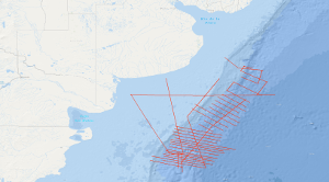
Processed seismic data of Cruise BGR98 1998
From 24th November 1998 to 24th February 1999 BGR in cooperation with YPF (Yacimientos Petrolíferos Fiscales) and SHN (Servicio de Hidrografía Naval) conducted three seismic surveys along the passive continental margin of Argentine. The seismic vessel M/V Akademik Lazarev which is operated by SMNG (Sevmorneftegeofizika) was used for these cruises. Although the seafloor spreading history of the South Atlantic Ocean is very well defined, the development of the continental margins poses still great problems to a profound understanding. When break-up of Gondwana started in Middle Jurassic, South Africa and South America remained connected. Their break-up started in Early Cretaceous, possibly propagating from south to north. Before break-up, huge tholeiitic flood basalts were extruded near the future rift, namely the Paraná basalts in Brazil and the Etendeka basalts in Namibia. It is likely that these basalts are caused by a large mantle plume. As the flood basalts were predecessors to the break-up, often a causal relationship is assumed. The dipping reflector sequences along large parts of the continental margins of South America and South Africa are interpreted as indications of the plume influence. Investigations along many passive margins have meanwhile shown that dipping reflector sequences exist along most of them. These so-called volcanic margins are the normal ones, the non-volcanic margins are the exception. For many years, it had been assumed that the hydrocarbon potential of volcanic margins is very low. The discovery of the Kudu gas field has demonstrated that this assumption is not valid in general. This increases our interest in continuing the investigation of volcanic passive margins and the variability of their structure along strike. BGR has carried out already two marine geophysical cruises off Argentina, namely with M/V EXPLORA in 1985 and with FS SONNE in 1993. These surveys had shown locally the existence of threefold dipping reflector sequences (Hinz et al., 1999). Furthermore, it had turned out that not everywhere they are accompanied by the strong magnetic G anomaly (Rabinowitz & LaBrecque, 1979). The main objectives of the BGR98 cruise were: (1) Investigation and mapping of the zone of the seaward dipping reflectors (SDR) (reflection + refraction seismic) (2) Investigation of the sedimentary column within this zone (reflection seismic) (3) Setting up a seismostratigraphy based on the seismic records obtained during the cruise and the information from the previous cruises (BGR87, SO85) as well as on additional well information (4) Comparison of the argentine seismic data with seismic data of the conjugate volcanic margin off Namibia (BGR 87). The study area is located offshore Argentine, extending from about 37° 20' S to 45° 40' S and from about 61° 10' W to 52° 00' W. It comprises the Colorado Basin as well as the outermost shelf, slope and rise of the continental margin with water depths up to 5000 m.
|
|
Citation proposal
. Processed seismic data of Cruise BGR98 1998. https://gdk.gdi-de.org/geonetwork/srv/api/records/f0438284-87df-43fd-8a64-eb0e5adc331a |
INSPIRE
Identification
- File identifier
- f0438284-87df-43fd-8a64-eb0e5adc331a XML
- Hierarchy level
- Dataset
Online resource
Resource identifier
- code
- 19ed7cb3-b2fa-2172-0a71-f28868dc209f
- Metadata language
- English
- Spatial representation type
- Vector
Encoding
- Format
- Shapefile
- Version
- n/a
Projection
Classification of data and services
- Topic category
-
- Geoscientific information
Classification of data and services
Coupled resource
Coupled resource
Classification of data and services
Coupled resource
Coupled resource
Keywords
- GEMET - INSPIRE themes, version 1.0 ( Theme )
-
- Geologie
- geology
- GEMET - Concepts, version 2.4 ( Theme )
-
- geophysics
- Geophysik
- raw material
- Rohstoff
Other keywords
- Keywords ( Theme )
-
- Marine geology
- Meeresgeologie
- Seismics
- Seismik
- Two-dimensional seismic reflection
- zweidimensionale Reflektionsseismik
- Keywords ( Place )
-
- Southwest Atlantic Ocean
- Südwestatlantik
- Argentinien
- Argentina
Geographic coverage
N
S
E
W
))
Temporal reference
Temporal extent
Temporal extent
- Date ( Creation )
- 1999-02-24
Quality and validity
- Lineage
- During the period from 24th November 1998 to 24th February 1999 BGR acquired seismic lines off the Atlantic coast of South America. The lines BGR98-001 to BGR98-047 consist of stacked data with exception of lines BGR98-003, BGR98-021 and BGR98-033 which are migrated data and lines BGR98-036, BGR98-037, BGR98-037A, BGR98-044 and BGR98-045 which consist of raw data.
Conformity
Conformity
Conformity
Conformity
Conformity
Conformity
- Explanation
- siehe dazu die angegebene Durchführungsbestimmung
Restrictions on access and use
- Access constraints
- Allgemeine Geschäftsbedingungen, siehe http://www.bgr.bund.de/AGB - General terms and conditions, see http://www.bgr.bund.de/AGB_en. Die bereitgestellten Informationen sind bei Weiterverwendung wie folgt zu zitieren: Datenquelle: BGR98 1998, (c) BGR, Hannover, 2018
Restrictions on access and use
Responsible organization (s)
Contact for the resource
- Organisation name
- Federal Institute for Geosciences and Natural Resources
- Marine_Seismik@bgr.de
Responsible organization (s)
Contact for the resource
- Organisation name
- Federal Institute for Geosciences and Natural Resources
- Marine_Seismik@bgr.de
Metadata information
Contact for the metadata
- Organisation name
- Bundesanstalt für Geowissenschaften und Rohstoffe (BGR)
- Date stamp
- 2023-11-16
- Metadata language
- English
- Character set
- UTF8
SDS
Conformance class 1: invocable
Access Point URL
Endpoint URL
Technical specification
Conformance class 2: interoperable
Coordinate reference system
Quality of Service
Access constraints
Limitation
Use constraints
Limitation
Responsible custodian
Contact for the resource
Conformance class 3: harmonized
Overviews
Provided by

Views
f0438284-87df-43fd-8a64-eb0e5adc331a
Access to the portal
Read here the full details and access to the data.
Associated resources
Not available