 www.geodatenkatalog.de (S3L)
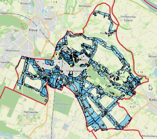
LEP/RP Vorrangflächen Bedburg-Hau
Der Layer „Vorrang Flächen“ stellt für die Kommune Bedburg-Hau, die vorzugsweise zu nutzende Fläche für raumbedeutsame Freiflächenphotovoltaikanlagen entsprechend Landesentwicklungsplans dar.
Die Daten stammen vom Energieatlas des Landesamtes für Natur, Umwelt und Verbraucherschutz Nordrhein-Westfalen und sind pro Kommune ausgewertet.
|
|
Citation proposal
(2024) . LEP/RP Vorrangflächen Bedburg-Hau. Kreis Kleve - Der Landrat https://gdk.gdi-de.org/geonetwork/srv/api/records/f12a7164-6f9a-48c2-aad3-9b4e5f68b2c8 |
INSPIRE
Identification
- File identifier
- f12a7164-6f9a-48c2-aad3-9b4e5f68b2c8 XML
- Hierarchy level
- dataset Dataset
Online resource
Resource identifier
- Metadata language
- German
Encoding
Projection
Classification of data and services
- Topic category
-
- Planning cadastre
Classification of data and services
Coupled resource
Coupled resource
Classification of data and services
Coupled resource
Coupled resource
Keywords
- UMTHES Thesaurus ( Theme )
- GEMET - Concepts, version 3.1 ( Theme )
Other keywords
- Keywords
-
- Kreis Kleve
- Bedburg-Hau
- Kleve
- NW
- NRW
- Nordrhein-Westfalen
- Geoportal
- 051540004004
- PV
- Solar
- Modulfläche
- Energieatlas
- Leistung
- Energien
- Erneuerbare
- potenziell
- Photovoltaikanlage
- Freiflächen
- Vorrangflächen
- LEP/RP
- Landesentwicklungsplan
- opendata
- Keywords ( Theme )
-
- ENER
Geographic coverage
N
S
E
W
))
Temporal reference
Temporal extent
Temporal extent
- Date ( Publication )
- 2024-05-11T00:00:00.000+02:00
Quality and validity
- Lineage
-
Bundesnetzagentur - Anlagenregister zu den Erneuerbaren Energien
Übertragungsnetzbetreiber Amprion GmbH und TenneT B V - Meldedaten nach EEG
Conformity
Conformity
Conformity
Conformity
Conformity
Conformity
Restrictions on access and use
- Access constraints
- Datenlizenz Deutschland - Zero - Version 2.0 [https://www.govdata.de/dl-de/zero-2-0]
- Access constraints
- {"id":"dl-zero-de/2.0","name":"Datenlizenz Deutschland – Zero – Version 2.0","url":"https://www.govdata.de/dl-de/zero-2-0","quelle":""}
Restrictions on access and use
Responsible organization (s)
Contact for the resource
- Organisation name
- Kreis Kleve - Der Landrat
- info@kreis-kleve.de
- Organisation name
- Kreis Kleve - Abt. Kataster- und Vermessung - Produktbereich GeoInformation (GIS)
Responsible organization (s)
Contact for the resource
- Organisation name
- Kreis Kleve - Der Landrat
- info@kreis-kleve.de
- Organisation name
- Kreis Kleve - Abt. Kataster- und Vermessung - Produktbereich GeoInformation (GIS)
Metadata information
Contact for the metadata
- Organisation name
- Kreis Kleve - Abt. Kataster- und Vermessung - Produktbereich GeoInformation (GIS)
- Date stamp
- 2025-02-26
- Metadata language
- German
SDS
Conformance class 1: invocable
Access Point URL
Endpoint URL
Technical specification
Conformance class 2: interoperable
Coordinate reference system
Quality of Service
Access constraints
Limitation
Use constraints
Limitation
Responsible custodian
Contact for the resource
Conformance class 3: harmonized
Overviews
Vorrangflächen Bedburg-Hau
Provided by

Views
f12a7164-6f9a-48c2-aad3-9b4e5f68b2c8
Access to the portal
Read here the full details and access to the data.
Associated resources
Not available