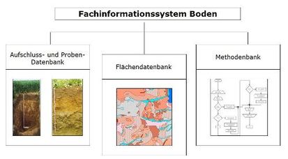
Fachinformationssystem Boden - FIS Boden
Die Aufgabe des Fachinformationssystems Boden ist es, die Vielzahl der im LfULG und an anderen Stellen vorhandenen und im Zuge eigener Erhebungen permanent neu hinzukommenden bodenkundlichen und bodenschutzrelevanten Informationen zusammenzufassen und für Anwendungen verschiedenster Art verfügbar zu machen.
|
|
Citation proposal
. Fachinformationssystem Boden - FIS Boden. https://gdk.gdi-de.org/geonetwork/srv/api/records/f2a6d092-be4e-412c-9cf0-0e2575756215 |
INSPIRE
Identification
- File identifier
- f2a6d092-be4e-412c-9cf0-0e2575756215 XML
- Hierarchy level
- application
Online resource
Resource identifier
- Metadata language
- German
Encoding
- Format
- Bodenkundliche Kartieranleitung
- Version
- 5. Auflage
Projection
Classification of data and services
- Topic category
-
- Environment
Classification of data and services
Coupled resource
Coupled resource
Classification of data and services
Coupled resource
Coupled resource
Keywords
- GEMET - Concepts, version 2.4 ( Theme )
-
- Boden
- Bodenfunktion
- Bodenstruktur
- Bodenprofil
- Pedosphäre
- Bodenuntersuchung
- Aufschluss
- Bohrung
- Bodenkunde
Other keywords
- Keywords ( Theme )
-
- Boden
- Bodendaten
- Keywords ( Theme )
-
- Fachinformationssystem
- Geoinformationssystem
Geographic coverage
N
S
E
W
))
Temporal reference
Temporal extent
Temporal extent
- Date ( Revision )
- 2013-01-01
Quality and validity
Conformity
Conformity
Conformity
Conformity
Conformity
Conformity
Restrictions on access and use
- Access constraints
- Die Daten des Fachinformationssystems Boden sind nach SächsUIG auf Antrag einseh- bzw. beziehbar.
- Access constraints
- Es gelten keine Bedingungen.
Restrictions on access and use
Responsible organization (s)
Contact for the resource
- Organisation name
- Sächsisches Landesamt für Umwelt, Landwirtschaft und Geologie
Responsible organization (s)
Contact for the resource
- Organisation name
- Sächsisches Landesamt für Umwelt, Landwirtschaft und Geologie
Metadata information
Contact for the metadata
- Organisation name
- Sächsisches Landesamt für Umwelt, Landwirtschaft und Geologie
- Date stamp
- 2023-08-14
- Metadata language
- German
- Character set
- UTF8
SDS
Conformance class 1: invocable
Access Point URL
Endpoint URL
Technical specification
Conformance class 2: interoperable
Coordinate reference system
Quality of Service
Access constraints
Limitation
Use constraints
Limitation
Responsible custodian
Contact for the resource
Conformance class 3: harmonized
Overviews

Provided by

Views
f2a6d092-be4e-412c-9cf0-0e2575756215
Access to the portal
Read here the full details and access to the data.
Associated resources
Not available
 www.geodatenkatalog.de (S1L)