 www.geodatenkatalog.de (S3L)
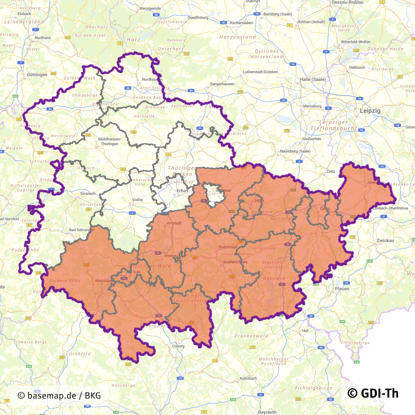
FSME-Risikogebiete in Thüringen
Risikogebiete der durch Zecken übertragbaren Frühsommer-Meningoenzephalitis (FSME) in Thüringen. Es handelt sich um einen Sekundärdatenbestand des Robert Koch-Institut.
Quelle: Robert Koch-Institut (RKI): FSME-Risikogebiete in Deutschland (Stand: Januar 2025, Veröffentlichung: 27.02.2025)
Epid Bull 2025;9:3-23 | DOI 10.25646/13037
Ein Kreis wird als FSME-Risikogebiet definiert, wenn die Anzahl der übermittelten FSME-Erkrankungen in mindestens einem der 19 Fünfjahreszeiträume im Zeitraum 2002 – 2024 im Kreis ODER in der Kreisregion (bestehend aus dem betreffenden Kreis plus allen angrenzenden Kreisen) signifikant (p < 0,05) höher liegt als die bei einer Inzidenz von eine Erkrankung pro 100.000 Einwohner erwartete Fallzahl.
|
|
Citation proposal
. FSME-Risikogebiete in Thüringen. https://gdk.gdi-de.org/geonetwork/srv/api/records/f2d62ccd-279e-477b-a47c-b8444a161c4d |
INSPIRE
Identification
- File identifier
- f2d62ccd-279e-477b-a47c-b8444a161c4d XML
- Hierarchy level
- Dataset
Online resource
- Protocol
- WWW:LINK-1.0-http--link
- Protocol
- WWW:LINK-1.0-http--download
Resource identifier
- Metadata language
- German
- Spatial representation type
- Vector
Encoding
- Format
- ESRI Shapefile
- Version
- 1.0
Projection
Classification of data and services
- Topic category
-
- Health
Classification of data and services
Coupled resource
Coupled resource
Classification of data and services
Coupled resource
Coupled resource
Keywords
- GEMET - INSPIRE themes, version 1.0 ( Theme )
-
- Gesundheit und Sicherheit
Other keywords
- Keywords
-
- Thüringen
- Robert Koch-Institut
- RKI
- Frühsommer-Meningoenzephalitis
- FSME
- Krankheit
- Holzbock
- Zecken
- HEAL
- REGI
- GOVE
- SOCI
- opendata
Geographic coverage
))
Temporal reference
Temporal extent
Temporal extent
- Date ( Creation )
- 2022-02-14
- Date ( Revision )
- 2025-02-27
Quality and validity
- Lineage
- Die Geodaten sind Eigentum des Robert Koch-Instituts (RKI) bearbeitet durch das Thüringer Landesamt für Bodenmanagement und Geoinformation
- Denominator
- 1000000
Conformity
Conformity
Conformity
Conformity
Conformity
Conformity
- Explanation
- mit GDI-DE Testsuite validiert
- Explanation
- mit GDI-DE Testsuite validiert
- Explanation
- mit GDI-DE Testsuite validiert
- Explanation
- Originäre Daten
Restrictions on access and use
- Access constraints
- Nutzungsbedingungen: Datenlizenz Deutschland-Namensnennung 2.0 in JSON Syntax
- Access constraints
- {"id": "dl-by-de/2.0", "name": "Datenlizenz Deutschland Namensnennung 2.0", "url": "https://www.govdata.de/dl-de/by-2-0 ", "quelle": "© GDI-Th"}
Restrictions on access and use
Responsible organization (s)
Contact for the resource
- Organisation name
- Thüringer Landesamt für Bodenmanagement und Geoinformation
Responsible organization (s)
Contact for the resource
- Organisation name
- Thüringer Landesamt für Bodenmanagement und Geoinformation
Metadata information
Contact for the metadata
- Organisation name
- Thüringer Landesamt für Bodenmanagement und Geoinformation
- Date stamp
- 2025-02-27T16:39:43
- Metadata language
- German
SDS
Conformance class 1: invocable
Access Point URL
Endpoint URL
Technical specification
Conformance class 2: interoperable
Coordinate reference system
Quality of Service
Access constraints
Limitation
Use constraints
Limitation
Responsible custodian
Contact for the resource
Conformance class 3: harmonized
Overviews
Provided by
