 My GeoNetwork catalogue
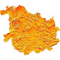
Einstrahlungsgrid - Einstrahlungsgrid St. Wendel
Der Kartendienst (WMS Gruppe) stellt Daten des Einstrahlungsgrid des Saarlandes dar.:Das Einstrahlungsgrid umfasst die Darstellung der Sonneneinstrahlung für den Landkreis St. Wendel als jährliche Einstrahlung pro m² (Einheit kWh/a) auf die Bodenfläche, ausgewiesen in Quadraten von jeweils 100 m². Das Grid kann als Hilfe zur Planung von Freiflächenphotovoltaikanlagen dienen. Ebenso kann es unterstützend in Planungsprozessen in den Bereichen Tourismus, Raumplanung, Land- und Forstwirtschaft zum Einsatz kommen.
Simple
Identification info
- Date (Revision)
- 2025-04-15
- Keywords
-
-
Photovoltaik
-
Sonneneinstrahlung
-
Einstrahlungsgrid
-
infoMapAccessService
-
wetter_klima
-
- Access constraints
- Other restrictions
- Other constraints
- INSPIRE: Keine Beschränkungen des öffentlichen Zugangs: Es existieren keine Beschränkungen des öffentlichen Zugangs zu Daten und Diensten
- Use constraints
- Other restrictions
- Other constraints
- Es gelten keine Bedingungen
- Service Type
- view
- Service Version
-
OGC:WMS 1.1.1
))
- Coupling Type
- Tight
Contains Operations
- Operation Name
-
GetCapabilities
- Distributed Computing Platforms
- Web services
- Distribution format
-
- OnLine resource
-
Einstrahlungsgrid_WND
(
OGC:WMS-1.1.1-http-get-map
)
Das Einstrahlungsgrid umfasst die Darstellung der Sonneneinstrahlung für den Landkreis St. Wendel als jährliche Einstrahlung pro m² (Einheit kWh/a) auf die Bodenfläche, ausgewiesen in Quadraten von jeweils 100 m². Das Grid kann als Hilfe zur Planung von Freiflächenphotovoltaikanlagen dienen. Ebenso kann es unterstützend in Planungsprozessen in den Bereichen Tourismus, Raumplanung, Land- und Forstwirtschaft zum Einsatz kommen.
- Hierarchy level
- Service
- Other
-
Dienst
Conformance result
- Date (Publication)
- 2010-12-08
- Explanation
-
No explanation available
- Pass
- Yes
Conformance result
- Date (Publication)
- 2009-10-20
- Explanation
-
No explanation available
- Pass
- Yes
Conformance result
- Date (Publication)
- 2014-12-11
- Explanation
-
No explanation available
- Pass
- Yes
Conformance result
- Date (Publication)
- 2008-12-04
- Explanation
-
No explanation available
- Pass
- Yes
Conformance result
- Date (Publication)
- 2014-12-11
- Explanation
-
No explanation available
- Pass
- Yes
Conformance result
- Date (Publication)
- 2013-12-10
- Explanation
-
No explanation available
- Pass
- Yes
Conformance result
- Date (Publication)
- 2011-02-05
- Explanation
-
No explanation available
- Pass
- Yes
Conformance result
- Date (Publication)
- 2010-12-08
- Explanation
-
No explanation available
- Pass
- Yes
- File identifier
- f3786141-2564-0502-d3b9-3334d1a93007 XML
- Metadata language
- Deutsch
- Character set
- UTF8
- Hierarchy level
- Service
- Hierarchy level name
-
Darstellungsdienst
- Date stamp
- 2025-04-15
- Metadata standard name
-
ISO19119
- Metadata standard version
-
2005/PDAM 1
Overviews
Spatial extent
Provided by
