 www.geodatenkatalog.de (S3L)
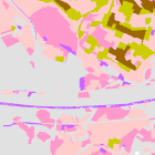
Natürliche Ertragsfähigkeit landwirtschaftlich genutzter Böden 1:25.000
Die Auswertungskarte „Natürliche Ertragsfähigkeit landwirtschaftlich genutzter Böden“ wird aus der Acker- bzw. Grünlandzahl der Bodenschätzung abgeleitet. Die Kasseneinteilung erfolgt nach „Umweltministerium Baden-Württemberg (1995): Bewertung von Böden nach ihrer Leistungsfähigkeit, Leitfaden für Planungen und Gestattungsverfahren, Luft, Boden, Abfall“, Heft 31, S. 14, Methode 5.1.3 „Standort für Kulturpflanzen“. Die Karte gibt Hinweise, welche Standorte sich aufgrund ihrer hohen Ertragsfähigkeit besonders für die landwirtschaftliche Nutzung eignen.
|
|
Citation proposal
. Natürliche Ertragsfähigkeit landwirtschaftlich genutzter Böden 1:25.000. https://gdk.gdi-de.org/geonetwork/srv/api/records/f5ec408b-ef71-466a-b578-c5193bc6b171 |
INSPIRE
Identification
- File identifier
- f5ec408b-ef71-466a-b578-c5193bc6b171 XML
- Hierarchy level
- dataset Dataset
Online resource
Resource identifier
- Metadata language
- German
- Spatial representation type
- Vector
Encoding
- Format
- GDB
Projection
Classification of data and services
- Topic category
-
- Environment
- Farming
- Geoscientific information
Classification of data and services
Coupled resource
Coupled resource
Classification of data and services
Coupled resource
Coupled resource
Keywords
Other keywords
- Keywords
-
- UmweltAtlas
- CC-BY
- gdiby
- BFK25
- Bodenfunktion
- Bodenkarte
- Bodenausgangsgestein
- Boden
- opendata
- Keywords ( Theme )
-
- ENVI
Geographic coverage
N
S
E
W
))
Temporal reference
Temporal extent
Temporal extent
- Date ( Creation )
- 2023-04-19T00:00:00.000+02:00
Quality and validity
- Lineage
- Datengrundlage für die Auswertungskarten sind Flächen- und Punktdaten. Flächendaten sind die nutzungsdifferenzierte (d.h.: nach Forst und Nicht-Forst unterschiedene) UEBK25 mit ihren nutzungsdifferenzierten Legendeneinheiten. Punktdaten sind sogenannte flächenrepräsentative Bodenprofile, welche die einzelnen nutzungsdifferenzierten Legendeneinheiten der ÜBK25 mit einem bestimmten Prozentsatz durch ihre Eigenschaften beschreiben. Die 100% Fläche jeder einzelnen nutzungsdifferenzierten Legendeneinheit der ÜBK25 wird von einem oder mehreren flächenrepräsentativen Bodenprofil/en mit seinen/ihren Eigenschaften in der Summe mit 100% beschrieben.
Conformity
Conformity
Conformity
Conformity
Conformity
Conformity
Restrictions on access and use
- Access constraints
- Creative Commons Namensnennung 4.0 International (CC BY 4.0); Datenquelle: Bayerisches Landesamt für Umwelt, www.lfu.bayern.de; Die Nutzung von Daten über Dienste ist geldleistungsfrei. Bei Bezug von Daten über die Datenstelle des LfU (nur Daten, die nicht über Dienste verfügbar sind) wird eine Bereitstellungsgebühr erhoben, die sich an der Umweltgebührenordnung orientiert.
- Access constraints
- {"id":"cc-by/4.0","name":"Creative Commons Namensnennung 4.0 International (CC BY 4.0)","url":"https://creativecommons.org/licenses/by/4.0/deed.de","quelle":"Bayerisches Landesamt für Umwelt, www.lfu.bayern.de"}
Restrictions on access and use
Responsible organization (s)
Contact for the resource
- Organisation name
- Bayerisches Landesamt für Umwelt
Responsible organization (s)
Contact for the resource
- Organisation name
- Bayerisches Landesamt für Umwelt
Metadata information
Contact for the metadata
- Organisation name
- Bayerisches Landesamt für Umwelt
- Date stamp
- 2024-06-28
- Metadata language
- German
- Character set
- UTF8
SDS
Conformance class 1: invocable
Access Point URL
Endpoint URL
Technical specification
Conformance class 2: interoperable
Coordinate reference system
Quality of Service
Access constraints
Limitation
Use constraints
Limitation
Responsible custodian
Contact for the resource
Conformance class 3: harmonized
Overviews
Provided by

Views
f5ec408b-ef71-466a-b578-c5193bc6b171
Access to the portal
Read here the full details and access to the data.
Associated resources
Not available