 www.geodatenkatalog.de (S1L)
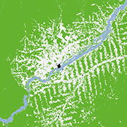
TanDEM-X Forest/Non-Forest Map - Global
The TanDEM-X Forest/Non-Forest Map is a project developed by the Microwaves and Radar Institute at the German Aerospace Center (DLR), within the activities of the TanDEM-X mission. The goal is the derivation of a global forest/non-forest classification mosaic from TanDEM-X bistatic interferometric synthetic aperture radar (InSAR) data, acquired for the generation of the global digital elevation model (DEM) in Stripmap single polarization (HH) mode.
The TanDEM-X Forest/Non-Forest Map (FNF) has been generated by processing and mosaicking more than 500,000 TanDEM-X bistatic images acquired from 2011 until 2015. The map has a spatial resolution of 50 x 50m. Forested and non-forested areas are depicted in green and white, respectively. Water bodies are depicted in blue and black is used for identifying urban areas and invalid pixels.
For more information, please visit:
https://www.dlr.de/hr/en/desktopdefault.aspx/tabid-12538/21873_read-50027/
|
|
Citation proposal
. TanDEM-X Forest/Non-Forest Map - Global. German Aerospace Center (DLR) https://gdk.gdi-de.org/geonetwork/srv/api/records/f607d44f-5cb2-4c84-837f-753000d1a907 |
INSPIRE
Identification
- File identifier
- f607d44f-5cb2-4c84-837f-753000d1a907 XML
- Hierarchy level
- Dataset
Online resource
- Protocol
- WWW:LINK-1.0-http--link
- Protocol
- OGC:WMS
- Protocol
- OGC:WMS
- Protocol
- OGC:WMS
- Protocol
- OGC:WMS
- Protocol
- WWW:LINK-1.0-http--link
- Protocol
- WWW:DOWNLOAD-1.0-http--download
- Protocol
- WWW:LINK-1.0-http--link
- Protocol
- WWW:LINK-1.0-http--link
- Protocol
- WWW:LINK-1.0-http--link
Resource identifier
- Metadata language
- English
- Spatial representation type
- Grid
Encoding
Projection
- code
- WGS 84 (EPSG:4326)
Classification of data and services
- Topic category
-
- Imagery base maps earth cover
- Biota
- Environment
Classification of data and services
Coupled resource
Coupled resource
Classification of data and services
Coupled resource
Coupled resource
Keywords
- GEMET - INSPIRE themes, version 1.0 ( Theme )
-
- Land cover
Other keywords
- Keywords
-
- TanDEM-X
- TSX-1
- TDX-1
- Interferometric SAR
- Land Use
- Forest
- Volume Correlation Factor
- Coherence
- Global
Geographic coverage
))
Temporal reference
Temporal extent
Temporal extent
- Date ( Creation )
- 2019-04-04T00:00:00
Quality and validity
- Lineage
-
The TanDEM-X global Forest/Non-Forest map dataset is based on the TanDEM-X bistatic interferometric synthetic aperture radar (InSAR) data. Using a fully automated InSAR processing and mosaicking system, more than 500,000 quicklook SAR images (50 m ground resolution), acquired between 2011 and 2015 and covering twice the Earth’s land surface, have been analyzed. Thereby, the volume correlation factor of the InSAR data have been used in combination with several TanDEM-X observables such as the bistatic coherence, the calibrated amplitude, and the digital elevation model (DEM) height information to distinguish between forested and non-forested areas on the Earth in a completely automated, complex decision-making process.
For more details see:
M. Martone, P. Rizzoli, C. Wecklich, C. Gonzalez, J. L. Bueso-Bello, P. Valdo, D. Schulze, M. Zink, G. Krieger, A. Moreira, The Global Forest/Non-Forest Map from TanDEM-X Interferometric SAR Data, Remote Sensing of Environment, February 2018.
M. Martone, P. Rizzoli, G. Krieger, Volume Decorrelation Effects in TanDEM-X Interferometric SAR Data, IEEE GRSL, Vol. 13, No. 12, December 2016.
- Denominator
- 100000
Conformity
Conformity
Conformity
Conformity
Conformity
Conformity
- Explanation
- See the referenced specification.
Restrictions on access and use
- Access constraints
- Nutzungsbedingungen: https://geoservice.dlr.de/resources/licenses/fnf50/Lizenz_fuer_die_Nutzung_der_TanDEM-X_50m_Waldkarte_fuer_wissenschaftliche_Zwecke.pdf / Terms of Use: https://geoservice.dlr.de/resources/licenses/fnf50/License_for_the_Utilization_of_TanDEM-X_50m_FNF_for_Scientific_Use.pdf
Restrictions on access and use
Responsible organization (s)
Contact for the resource
- Organisation name
- German Aerospace Center (DLR)
- forestmap@dlr.de
- Organisation name
- German Aerospace Center (DLR)
- geoservice@dlr.de
Responsible organization (s)
Contact for the resource
- Organisation name
- German Aerospace Center (DLR)
- forestmap@dlr.de
- Organisation name
- German Aerospace Center (DLR)
- geoservice@dlr.de
Metadata information
Contact for the metadata
- Organisation name
- German Aerospace Center (DLR)
- geoservice@dlr.de
- Date stamp
- 2024-06-20T13:08:01
- Metadata language
- English
- Character set
- UTF8
SDS
Conformance class 1: invocable
Access Point URL
Endpoint URL
Technical specification
Conformance class 2: interoperable
Coordinate reference system
Quality of Service
Access constraints
Limitation
Use constraints
Limitation
Responsible custodian
Contact for the resource
Conformance class 3: harmonized
Overviews

Provided by
