 www.geodatenkatalog.de (S3L)
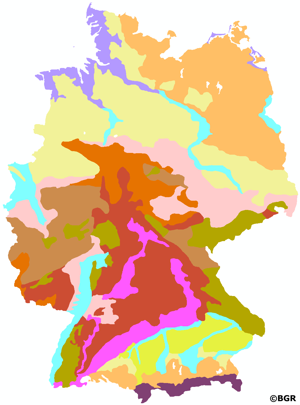
Soil Regions of the Federal Republic of Germany 1:5,000,000
Small-scale soil maps at scales of 1:200,000 to 1:5,000,000 are usually compiled from large- or medium-scale soil maps by summarizing the soil units depicted there. A uniform pedoregional classification is required to ensure a comparable approach across regions. In this data set, the top level of soil mapping in Germany is presented in 12 soil regions and described in German and English in terms of content. This new map of soil regions is the result of a content and spatial summary of the legend units of the soil landscapes of Germany at a scale of 1:5,000,000, version 4.0. More detailed information on the soil regions and soil landscapes of the Federal Republic of Germany can be found in the Soil Mapping Manual (KA5), chapter 6.5 starting on page 335.
|
|
Citation proposal
(2023) . Soil Regions of the Federal Republic of Germany 1:5,000,000. https://gdk.gdi-de.org/geonetwork/srv/api/records/f877ce17-5081-4db8-9214-7f018bd5df42 |
INSPIRE
Identification
- File identifier
- f877ce17-5081-4db8-9214-7f018bd5df42 XML
- Hierarchy level
- Dataset
Online resource
Resource identifier
- code
- 15008219-76C6-4CF4-AC7B-13BAC32E5686
- Metadata language
- German
- Spatial representation type
- Vector
Encoding
- Format
- Shapefile
- Version
- n/a
- Format
- tiff
- Version
- n/a
- Format
- jpg
- Version
- n/a
- Format
- Version
- n/a
- Format
- png
- Version
- n/a
Projection
Classification of data and services
- Topic category
-
- Geoscientific information
Classification of data and services
Coupled resource
Coupled resource
Classification of data and services
Coupled resource
Coupled resource
Keywords
- GEMET - INSPIRE themes, version 1.0 ( Theme )
-
- Soil
- Boden
- GEMET - Concepts, version 2.4 ( Theme )
-
- Bodenart
- Bodengestaltung
- Bodenkarte
- Bodenfunktion
- Bodenbelastung
- Bodenfruchtbarkeit
- Bodennutzung
- Bodenbildung
- SGD-Liste ( Theme )
-
- Bodengruppe
- Bodenverbreitung
- Bodeneigenschaften
Other keywords
- Keywords ( Place )
-
- Bundesrepublik Deutschland
- Keywords ( Theme )
-
- Bodensystematik
- Bodeninformationssystem
- Bodenausgangsgestein
- Bodenregion
- Bodengesellschaft
- FISBo BGR
Geographic coverage
N
S
E
W
))
Temporal reference
Temporal extent
Temporal extent
- Date ( Creation )
- 2023-01-10
- Date ( Publication )
- 2023-02-01
Quality and validity
- Lineage
- Bodengroßlandschaften von Deutschland 1:5.000.000, Version 4.0. Im Landesteil Mecklenburg-Vorpommern Einarbeitung von Änderungsvorschlägen des LUNG Mecklenburg-Vorpommern (Frank Idler, 21. September 2021).
Conformity
Conformity
Conformity
Conformity
Conformity
Conformity
Restrictions on access and use
- Access constraints
- Allgemeine Geschäftsbedingungen, siehe http://www.bgr.bund.de/AGB - General terms and conditions, see http://www.bgr.bund.de/AGB_en. Die bereitgestellten Informationen sind bei Weiterverwendung wie folgt zu zitieren: Datenquelle: BR5000 V4.0, (C) BGR, Hannover, 2023.
Restrictions on access and use
Responsible organization (s)
Contact for the resource
- Organisation name
- Bundesanstalt für Geowissenschaften und Rohstoffe (BGR)
- fis.bo@bgr.de
Responsible organization (s)
Contact for the resource
- Organisation name
- Bundesanstalt für Geowissenschaften und Rohstoffe (BGR)
- fis.bo@bgr.de
Metadata information
Contact for the metadata
- Organisation name
- Bundesanstalt für Geowissenschaften und Rohstoffe (BGR)
- Date stamp
- 2025-02-12
- Metadata language
- German
SDS
Conformance class 1: invocable
Access Point URL
Endpoint URL
Technical specification
Conformance class 2: interoperable
Coordinate reference system
Quality of Service
Access constraints
Limitation
Use constraints
Limitation
Responsible custodian
Contact for the resource
Conformance class 3: harmonized
Overviews
Provided by

Views
f877ce17-5081-4db8-9214-7f018bd5df42
Access to the portal
Read here the full details and access to the data.
Associated resources
Not available