 www.geodatenkatalog.de (S1L)
Benachteiligtes Gebiet
Ein Bestandteil des Digitalen Feldblockkatasters ist die Förderkulisse der benachteiligten Gebiete. Dabei handelt es sich insbesondere um Flächen, deren Ertragsfähigkeit natürlich stark begrenzt ist, wie das beispielsweise bei Sandböden der Fall sein kann. Die benachteiligten Gebiete wurden nach Vorgaben der Europäischen Union abgegrenzt. Damit derart problematische Landwirtschaftsflächen nicht brach fallen und weiter bewirtschaftet werden, gewährt das Land Brandenburg eine Beihilfe, die sogenannte Ausgleichszulage.
|
|
Citation proposal
. Benachteiligtes Gebiet. https://gdk.gdi-de.org/geonetwork/srv/api/records/f901b82c-54b7-4ef1-8365-2205da79c79b |
INSPIRE
Identification
- File identifier
- f901b82c-54b7-4ef1-8365-2205da79c79b XML
- Hierarchy level
- dataset Dataset
Online resource
Resource identifier
- Metadata language
- German
- Spatial representation type
- Vector
Encoding
- Format
- GeoPackage
- Format
- Shapefiles
- Format
- ZIP
Projection
Classification of data and services
- Topic category
-
- Farming
Classification of data and services
Coupled resource
Coupled resource
Classification of data and services
Coupled resource
Coupled resource
Keywords
Other keywords
- Keywords
-
- Landwirtschaft
- Ressource
- Kataster
- Vektordaten
- Förderkulisse
- opendata
- Keywords ( Theme )
-
- AGRI
Geographic coverage
N
S
E
W
))
Temporal reference
Temporal extent
Temporal extent
- Date ( Revision )
- 2022-07-01T00:00:00.000+02:00
- Date ( Creation )
- 2007-12-03T00:00:00.000+01:00
Quality and validity
- Lineage
- Erstellung durch Landesumweltamt Brandenburg bzw. später durch die LGB auf der Grundlage von Brandenburger Gemarkungen und Berliner Ortsteilen sowie der (landwirtschaftlichen) Fördergebietsgrenze Brandenburgs.
- Denominator
- 4800
Conformity
Conformity
Conformity
Conformity
Conformity
Conformity
Restrictions on access and use
- Access constraints
- Datenlizenz Deutschland Namensnennung 2.0
- Access constraints
- Quellenvermerk: Bei unveränderten Daten: ©MLEUV, dl-de/by-2-0, Bei veränderten Daten: ©MLEUV, dl-de/by-2-0, Daten verändert
- Access constraints
- {"id":"dl-by-de/2.0","name":"Datenlizenz Deutschland Namensnennung 2.0","url":"https://www.govdata.de/dl-de/by-2-0","quelle":"Bei unveränderten Daten: ©MLEUV, dl-de/by-2-0, Bei veränderten Daten: ©MLEUV, dl-de/by-2-0, Daten verändert"}
Restrictions on access and use
Responsible organization (s)
Contact for the resource
- Organisation name
- Ministerium für Land- und Ernährungswirtschaft, Umwelt und Verbraucherschutz (MLEUV)
- Organisation name
- Ministerium für Land- und Ernährungswirtschaft, Umwelt und Verbraucherschutz (MLEUV)
Responsible organization (s)
Contact for the resource
- Organisation name
- Ministerium für Land- und Ernährungswirtschaft, Umwelt und Verbraucherschutz (MLEUV)
- Organisation name
- Ministerium für Land- und Ernährungswirtschaft, Umwelt und Verbraucherschutz (MLEUV)
Metadata information
Contact for the metadata
- Organisation name
- Landesvermessung und Geobasisinformation Brandenburg (LGB)
- Date stamp
- 2025-06-11
- Metadata language
- German
- Character set
- UTF8
SDS
Conformance class 1: invocable
Access Point URL
Endpoint URL
Technical specification
Conformance class 2: interoperable
Coordinate reference system
Quality of Service
Access constraints
Limitation
Use constraints
Limitation
Responsible custodian
Contact for the resource
Conformance class 3: harmonized
Overviews
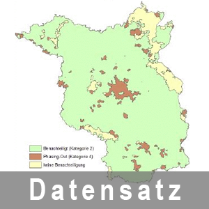
Anzeige der Benachteiligte Gebiete Land Brandenburg
Provided by

Views
f901b82c-54b7-4ef1-8365-2205da79c79b
Access to the portal
Read here the full details and access to the data.
Associated resources
Not available