 www.geodatenkatalog.de (S3L)
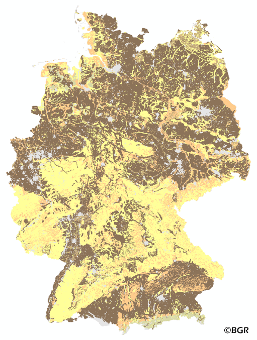
Soil depth in Germany
The map of the soil depth gives an overview of the rooting capacity of German soils. The soil depth is derived from profile data of the landuse stratified soil map of Germany at scale 1:1,000,000. The lower limit of a soil is bedrock or a groundwater influenced horizon. The method is derived from Bodenkundliche Kartieranleitung KA5 (2005) and is documented in the MethodenWIKI of the FISBo BGR. The land use information is derived from the CORINE Land Cover data set (2006).
|
|
Citation proposal
(2015) . Soil depth in Germany. https://gdk.gdi-de.org/geonetwork/srv/api/records/faee466f-27c1-44c9-bcb8-3c2bec8b1116 |
INSPIRE
Identification
- File identifier
- faee466f-27c1-44c9-bcb8-3c2bec8b1116 XML
- Hierarchy level
- Dataset
Online resource
Resource identifier
- code
- 3650b770-8d14-11e5-9984-8851fb422c62
- Metadata language
- German
- Spatial representation type
- Grid
Encoding
- Format
- georef. TIFF
- Version
- n/a
Projection
Classification of data and services
- Topic category
-
- Geoscientific information
Classification of data and services
Coupled resource
Coupled resource
Classification of data and services
Coupled resource
Coupled resource
Keywords
- GEMET - INSPIRE themes, version 1.0 ( Theme )
-
- Boden
- Soil
- GEMET - Concepts, version 2.4 ( Theme )
-
- Boden
- Bodenkarte
- SGD-Liste ( Theme )
-
- effektive Durchwurzelungstiefe
- Spatial scope
-
- National
- High-value dataset categories
-
- Erdbeobachtung und Umwelt
Other keywords
- Keywords ( Theme )
-
- Gründigkeit
- Mächtigkeit
- Bodentiefe
- inspireidentifiziert
- opendata
- Keywords ( Place )
-
- Bundesrepublik Deutschland
Geographic coverage
N
S
E
W
))
Temporal reference
Temporal extent
Temporal extent
- Date ( Creation )
- 2014-04-09
- Date ( Publication )
- 2015-08-03
Quality and validity
- Lineage
- Bodendaten aus BÜK1000N V2.31 (BGR), Landnutzungsdaten aus CORINE Land Cover 2006 (UBA/DLR).
- Denominator
- 1000000
Conformity
Conformity
Conformity
Conformity
Conformity
Conformity
- Explanation
- siehe dazu die angegebene Durchführungsbestimmung
Restrictions on access and use
- Access constraints
- Allgemeine Geschäftsbedingungen, siehe https://www.bgr.bund.de/AGB - General terms and conditions, see https://www.bgr.bund.de/AGB_en. Die bereitgestellten Informationen sind bei Weiterverwendung wie folgt zu zitieren: Datenquelle: PhysGru1000_250 V1.0, (c) BGR, Hannover, 2015.
- Access constraints
- Dieser Datensatz kann gemäß der "Nutzungsbestimmungen für die Bereitstellung von Geodaten des Bundes" (https://sg.geodatenzentrum.de/web_public/gdz/lizenz/geonutzv.pdf) genutzt werden.
- Access constraints
- {"id": "geoNutz/20130319", "name": "Nutzungsbestimmungen für die Bereitstellung von Geodaten des Bundes", "url": "https://sg.geodatenzentrum.de/web_public/gdz/lizenz/geonutzv.pdf", "quelle": "PhysGru1000_250 V1.0, (c) BGR, Hannover, 2015"}
Restrictions on access and use
Responsible organization (s)
Contact for the resource
- Organisation name
- Bundesanstalt für Geowissenschaften und Rohstoffe (BGR)
- fis.bo@bgr.de
Responsible organization (s)
Contact for the resource
- Organisation name
- Bundesanstalt für Geowissenschaften und Rohstoffe (BGR)
- fis.bo@bgr.de
Metadata information
Contact for the metadata
- Organisation name
- Bundesanstalt für Geowissenschaften und Rohstoffe (BGR)
- Date stamp
- 2024-04-23
- Metadata language
- German
- Character set
- UTF8
SDS
Conformance class 1: invocable
Access Point URL
Endpoint URL
Technical specification
Conformance class 2: interoperable
Coordinate reference system
Quality of Service
Access constraints
Limitation
Use constraints
Limitation
Responsible custodian
Contact for the resource
Conformance class 3: harmonized
Overviews
Provided by

Views
faee466f-27c1-44c9-bcb8-3c2bec8b1116
Access to the portal
Read here the full details and access to the data.
Associated resources
Not available