 My GeoNetwork catalogue
Biotopkartierung Bayern - Downloaddienst
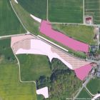
Der Datenbestand der Biotopkartierung Bayern gibt die Ergebnisse einer systematischen, bayernweiten Erfassung und Beschreibung naturnaher Lebensräume (Biotope) in Bayern wieder. Sie liefert somit eine vergleichbare Übersicht über Lage, Verbreitung, Häufigkeit und Zustand der wertvollen und erhaltenswerten Biotope in Bayern.
Die Biotopkartierung Bayern gliedert sich in vier Bereiche: die "Biotopkartierung (Flachland)" außerhalb der Alpen und Städte, die "Biotopkartierung (Alpen)", die "Biotopkartierung (Stadt)" sowie die "Biotopkartierung (Militär)" innerhalb militärischer Liegenschaften. Der Beginn der Biotopkartierung Bayern im Erfassungsmaßstab von 1:5.000 war im 1984. Seit 1993 werden innerhalb von Wäldern keine Biotope mehr kartiert. Insgesamt wurden seit 1985 in Bayern außerhalb der Alpen etwa 4% der Landesfläche als Biotope kartiert.
Die meisten der erfassten Biotope sind geschützt nach §30 des Bundesnaturschutzgesetzes (BNatSchG) bzw. Art. 23. des Bayerischen Naturschutzgesetzes (BayNatSchG).
Simple
Identification info
- Alternate title
-
Natur
- Date (Revision)
- 2025-08-14T00:00:00.000+02:00
- Status
- On going
- Maintenance and update frequency
- As needed
- Update scope
- Service
-
GEMET - INSPIRE themes, version 1.0
-
-
Lebensräume und Biotope
-
-
Service Classification, version 1.0
-
-
infoFeatureAccessService
-
- Keywords
-
-
gdiby
-
FFH-Lebensraumtypen
-
Biotopkartierung Bayern
-
gesetzlich geschützte Biotope
-
Vegetationskartierung
-
§30 Bundesnaturschutzgesetz
-
Art. 23 Bayerisches Naturschutzgesetz
-
opendata
-
- Theme
-
-
ENVI
-
- Keywords
-
-
inspireidentifiziert
-
- Use limitation
-
keine Einschränkungen
- Use constraints
- Other restrictions
- Other constraints
-
Creative Commons Namensnennung 4.0 International (CC BY 4.0); Datenquelle: Bayerisches Landesamt für Umwelt, www.lfu.bayern.de
- Other constraints
-
{"id":"cc-by/4.0","name":"Creative Commons Namensnennung 4.0 International (CC BY 4.0)","url":" https://creativecommons.org/licenses/by/4.0/deed.de","quelle":"Bayerisches Landesamt für Umwelt, www.lfu.bayern.de"}
- Access constraints
- Other restrictions
- Other constraints
- Es gelten keine Zugriffsbeschränkungen
- Service Type
- download
- Service Version
-
predefined ATOM
- Description
-
Der Dienst umfasst die Landesfläche Bayerns.
))
- Coupling Type
- Tight
Contains Operations
- Operation Name
-
GetDownloadServiceMetadata
- Distributed Computing Platforms
- Web services
- Connect Point
- https://www.lfu.bayern.de/gdi/dls/biotopkartierung.xml
Contains Operations
- Operation Name
-
DescribeSpatialDataset
- Distributed Computing Platforms
- Web services
- Connect Point
- https://www.lfu.bayern.de/gdi/dls/biotopkartierung.xml
Contains Operations
- Operation Name
-
GetSpatialDataset
- Distributed Computing Platforms
- Web services
- Connect Point
- https://www.lfu.bayern.de/gdi/dls/biotopkartierung.xml
Contains Operations
- Operation Name
-
GetCapabilities
- Distributed Computing Platforms
- Web services
- Connect Point
- https://www.lfu.bayern.de/gdi/dls/biotopkartierung.xml
- Unique resource identifier
- EPSG 25832: ETRS89 / UTM Zone 32N
- Unique resource identifier
- EPSG 4258: ETRS89 / geographisch
- Distribution format
-
-
Sonstiges
()
-
Sonstiges
()
Distributor
- Fees
-
geldleistungsfrei
- OnLine resource
-
Beschreibung der Sachdaten (Download)
Weiterführende Informationen zum bereitgestellten Datensatz der Biotopkartierung
- OnLine resource
-
Informationsseite des LfU zur Biotopkartierung
Ausführliche Information zur Biotopkartierung und weiterführende Links
- OnLine resource
-
https://www.lfu.bayern.de/gdi/dls/biotopkartierung.xml
URL des Dienstes
- OnLine resource
- Dienst "Biotopkartierung Bayern - Downloaddienst" (GetCapabilities) ( OGC Web Feature Service )
- Hierarchy level
- Service
- Other
-
service
Conformance result
- Date (Publication)
- 2013-08-09
- Explanation
-
see the referenced specification
- Pass
- Yes
Conformance result
- Date (Publication)
- 2009-10-20
- Explanation
-
see the referenced specification
- Pass
- Yes
Conformance result
- Date (Publication)
- 2010-12-07
- Explanation
-
see the referenced specification
- Pass
- No
- File identifier
- fe6588d6-0283-4c5c-9007-f31d0abc7cfb XML
- Metadata language
- Deutsch
- Character set
- UTF8
- Hierarchy level
- Service
- Hierarchy level name
-
service
- Date stamp
- 2026-04-08
- Metadata standard name
-
ISO19119
- Metadata standard version
-
2005/PDAM 1
Overviews
Spatial extent
Provided by
