 My GeoNetwork catalogue
Meteorological
Provided by
Type of resources
Available actions
Topics
Keywords
Contact for the resource
Update frequencies
-

The RV composite is a Germany composite of the amount of precipitation accumulated over a period of 5 minutes in mm. For graphical visualisation it was converted to mm/h. Horizontal resolution is 1 km x 1 km. The horizontal range of the DWD radar network is 1200 x 1100 with a class number of 4095 and an availability of 5 min.
-
The PE radar data is a location echo top product based on the volume radar scan. Horizontal resolution is 1 km x 1 km. The horizontal range within the DWD radar network is 180 km (400px x 400px). The product is produced every 5 minutes. The data resolution is 16 bit. The data is available for the following radar sites: ASR Borkum, Boostedt, Rostock, Hannover, Ummendorf, Prötzel, Essen, Korbach-Rhena Flechtdorf, Dresden, Neuhaus, Neuheilenbach, Offenthal, Eisberg, Türkheim, Isen, Feldberg, Memmingen. Up-to-date radar site data is available in the linked list of "Radar and wind profiler locations of DWD".
-
The PZ radar data is a site reflectivity product based on the volume scan. Horizontal resolution is 1km x 1km and the horizontal range is variable due to height dependency, but is a maximum of 180km (400px x 400px). The product is produced every 5 minutes. The data resolution is 16 bit. The data is available for the following radar sites: ASR Borkum, Boostedt, Rostock, Hannover, Ummendorf, Prötzel, Essen, Korbach-Rhena Flechtdorf, Dresden, Neuhaus, Neuheilenbach, Offenthal, Eisberg, Türkheim, Isen, Feldberg, Memmingen. Up-to-date radar site data is available in the linked list of "Radar and wind profiler locations of DWD".
-

These grids are a product derived from HYRAS-DE-PRE. HYRAS-DE-PRE is a precipitation product for Germany in a 1 km x 1 km grid for the period 1931 to the previous day and is based on daily measured values of precipitation height. The data set can be used, for example, for the analysis of past climate, for bias adjustment of regionalized climate projection data and as input data for hydrological modeling.
-

HYRAS-DE-PRE is a precipitation product for Germany in a 1 km x 1 km grid for the period 1931 to the previous day and is based on daily measured values of precipitation height. The data set can be used, for example, for the analysis of past climate, for bias adjustment of regionalized climate projection data and as input data for hydrological modeling.
-
calculated values for potential Evaporation over gras at DWD stations in the Regional Basic Synoptic Network of the WMO, plus additional stations from the so called "Global Dataset" of DWD
-

These grids are a product derived from HYRAS-DE-PRE. HYRAS-DE-PRE is a precipitation product for Germany in a 1 km x 1 km grid for the period 1931 to the previous day and is based on daily measured values of precipitation height. The data set can be used, for example, for the analysis of past climate, for bias adjustment of regionalized climate projection data and as input data for hydrological modeling.
-
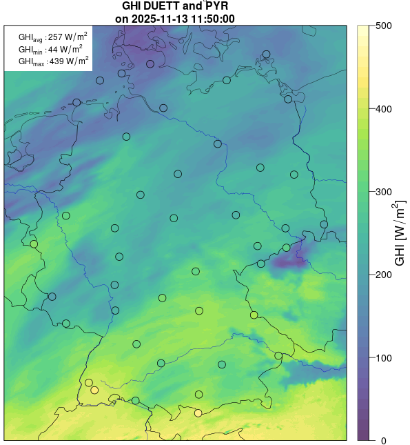
These data are generated by combining satellite-based and surface-measured data of the surface irradiance (global radiation) and the sunshine duration. The associated algorithms have been developed within the DUETT-project and are continuously adjusted and improved. Gridded data (EPSG-3035 projection, Germany) of the surface irradiance and the sunshine duration are generated with a spatial resolution of 1 km and a temporal resolution of 1 hour (average / sum for synoptic hours, ending at minute 50). The data set is separated into two parts: the directory ./{parameter}/recent/ contains the latest data; in the directory ./{parameter}/historical/ older data are archived.
-

These data are generated by combining satellite-based and surface-measured data of the surface irradiance (global radiation) and the sunshine duration. The associated algorithms have been developed within the DUETT-project and are continuously adjusted and improved. Gridded data (EPSG-3034 projection, Germany) of the surface irradiance and the sunshine duration are generated with a spatial resolution of 2 km and a temporal resolution of 1 hour (average / sum for synoptic hours, ending at minute 50). The data set is separated into two parts: the directory ./{parameter}/recent/ contains the latest data; in the directory ./{parameter}/historical/ older data are archived.
-
The LMAX radar data is a site reflectivity product based on the volume scan. The horizontal resolution is 1 km x 1 km. The horizontal range is 180 km (400px x 400px) around each radar site. The product is produced every 5 minutes. The data resolution is 16 bit. The data is available for the following radar sites: ASR Borkum, Boostedt, Rostock, Hannover, Ummendorf, Prötzel, Essen, Korbach-Rhena Flechtdorf, Dresden, Neuhaus, Neuheilenbach, Offenthal, Eisberg, Türkheim, Isen, Feldberg, Memmingen. Up-to-date radar site data is available in the linked list of "Radar and wind profiler locations of DWD".