 My GeoNetwork catalogue
Jura
Provided by
Type of resources
Available actions
Keywords
Contact for the resource
Update frequencies
Service types
-
Which salt formations are suitable for storing hydrogen or compressed air? In the InSpEE-DS research project, scientists developed requirements and criteria for the assessment of suitable sites even if their exploration is still at an early stage and there is little knowledge of the salinaries’ structures. Scientists at DEEP.KBB GmbH in Hanover, worked together with their project partners at BGR and the Leibniz University Hanover, Institute for Geotechnics, to develop the planning basis for the site selection and for the construction of storage caverns in flat layered salt and multiple or double saliniferous formations. Such caverns could store renewable energy in the form of hydrogen or compressed air. While the previous project InSpEE was limited to salt formations of great thickness in Northern Germany, salt horizons of different ages have now been examined all over Germany. To estimate the potential, depth contour maps of the top and the base as well as thickness maps of the respective stratigraphic units were developed. Due to the present INSPIRE geological data model, it was necessary, in contrast to the original dataset, to classify the boundary lines of the potential storage areas in the Zechstein base and thickness layers, whereby the classification of these lines was taken from the top Zechstein layer. Consequently, the boundary element Depth criterion 2000 m (Teufe-Kriterium 2000 m) corresponds on each level to the 2000 m depth of Top Zechstein. However, the boundary of national borders and the boundary of the data basis could not be implemented in the data model and are therefore not included in the dataset. Information on compressed air and hydrogen storage potential is given for the identified areas and for the individual federal states. According to the Data Specification on Geology (D2.8.II.4_v3.0) the content of InSpEE-DS (INSPIRE) is stored in 18 INSPIRE-compliant GML files: InSpEE_DS_GeologicUnit_Isopachs_Zechstein.gml contains the Zechstein isopachs. InSpEE_DS_GeologicUnit_Isobaths_Top_Zechstein.gml and InSpEE_DS_GeologicUnit_Isobaths_Basis_Zechstein.gml contain the isobaths of the top and basis of Zechstein. The three files InSpEE_DS_GeologicStructure_ThicknessMap_Zechstein, InSpEE_DS_GeologicStructure_Top_Zechstein and InSpEE_DS_GeologicStructure_Basis_Zechstein represent the faults of the Zechstein body as well as at the top and at the basis of the Zechstein body. InSpEE_DS_GeologicUnit_Boundary_element_Potential_areas_Zechstein.gml contains the boundary elments of the potential areas at the top and the basis of Zechstein as well as of the Zechstein body. The three files InSpEE_DS_GeologicUnit_Uncertainty_areas_ThicknessMap_Zechstein.gml, InSpEE_DS_GeologicUnit_Uncertainty_areas_Top_Zechstein.gml, InSpEE_DS_GeologicUnit_Uncertainty_areas_Basis_Zechstein.gml represent the uncertainty areas of the Zechstein body as well as at the top and at the basis of the Zechstein body. InSpEE_DS_GeologicUnit_Potentially_usable_storage_areas_Storage_potential_in_the_federal_states.gml comprises the areas with storage potential for renewable energy in the form of hydrogen and compressed air. The six files InSpEE_DS_GeologicUnit_Salt_distribution_in_Germany_Malm.gml, InSpEE_DS_GeologicUnit_Salt_distribution_in_Germany_Keuper.gml, InSpEE_DS_GeologicUnit_Salt_distribution_in_Germany_Muschelkalk.gml, InSpEE_DS_GeologicUnit_Salt_distribution_in_Germany_Roet.gml, InSpEE_DS_GeologicUnit_Salt_distribution_in_Germany_Zechstein.gml and InSpEE_DS_GeologicUnit_Salt_distribution_in_Germany_Rotliegend.gml represent the salt distribution of the respective stratigraphic unit. InSpEE_DS_GeologicUnit_General_salt_distribution.gml represents the general salt distribution in Germany. This geographic information is product of a BMWi-funded research project "InSpEE-DS" running from the year 2015 to 2019. The acronym stands for "Information system salt: planning basis, selection criteria and estimation of the potential for the construction of salt caverns for the storage of renewable energies (hydrogen and compressed air) - double saline and flat salt layers".
-
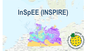
The WMS InSpEE (INSPIRE) provides information about the areal distribution of salt structures (salt domes and salt pillows) in Northern Germany. Contours of the salt structures can be displayed at horizontal cross-sections at four different depths up to a maximum depth of 2000 m below NN. The geodata have resulted from a BMWi-funded research project “InSpEE” running from the year 2012 to 2015. The acronym stands for "Information system salt structures: planning basis, selection criteria and estimation of the potential for the construction of salt caverns for the storage of renewable energies (hydrogen and compressed air)”. Taking into account the fact that this work was undertaken at a scale for providing an overview and not for investigation of single structures, the scale of display is limited to a minimum of 1:300.000. Additionally four horizontal cross-section maps display the stratigraphical situation at a given depth. In concurrence of maps at different depths areal bedding conditions can be determined, e.g. to generally assess and interpret the spread of different stratigraphic units. Clearly visible are extent and shape of the salt structures within their regional context at the different depths, with extent and boundary of the salt structures having been the main focus of the project. Four horizontal cross-section maps covering the whole onshore area of Northern Germany have been developed at a scale of 1:500.000. The maps cover the depths of -500, -1000, -1500, -2000 m below NN. The four depths are based on typical depth requirements of existing salt caverns in Northern Germany, mainly related to hydrocarbon storage. The shapes of the structures show rudimentary information of their geometry and their change with depths. In addition they form the starting point for rock mechanical calculations necessary for the planning and construction of salt caverns for storage as well as for assessing storage potentials. The maps can be used as a pre-selection tool for subsurface uses. It can also be used to assess coverage and extension of salt structures. Offshore areas were not treated within the project. All horizontal cross-section maps were adjusted with the respective state geological survey organisations. According to the Data Specification on Geology (D2.8.II.4_v3.0) the WMS InSpEE (INSPIRE) provides INSPIRE-compliant data. The WMS InSpEE (INSPIRE) contains two group layers: The first group layer “INSPIRE: Salt structures in Northern Germany“ comprises the layers GE.Geologic.Unit.Salt structure types, GE.GeologicUnit.Salt pillow remnants, GE.GeologicUnit.Structure-building salinar and GE.GeologicUnit.Structural outlines. The layer GE.GeologicUnit.Structural outlines contains according to the four depths four sublayers, e.g. GE.GeologiUnit.Structural outlines 500 m below NN. The second group layer „INSPIRE: Horizontal cross-section maps of Northern Germany“ comprises according to the four depths four layers, e.g. Horizontal cross-section map – 500 m below NN. This layer, in turns, contains two sublayers: GE.GeologicFault.Relevant fault traces and GE.GeologicUnit.Stratigraphic Units. Via the getFeatureInfo request the user obtains additional information on the different geometries. In case of the GE.Geologic.Unit.Salt structure types the user gets access to a data sheet with additional information and further reading in German for the respective salt structure via the getFeatureInfo request.
-
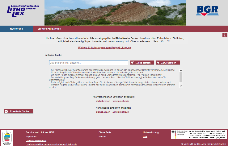
The lithostratigraphic lexicon "LithoLex" is a dynamic database that comprises all defined lithostratigraphic units of Germany and makes them accessible to the public via a web interface. LithoLex is a joint-venture of the German Stratigraphic Commission (Deutsche Stratigraphische Kommission - DSK) and the Federal Institute of Geosciences and Natural Resources (BGR). The DSK and its subcommissions are providing the content, i.e. definitions and descriptions of the lithostratigraphic units, whereas the BGR is in charge of maintaining the database and providing these geoinformation to the public.
-
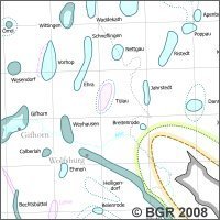
New map of salt structures in northern Germany at a scale of 1:500,000.
-
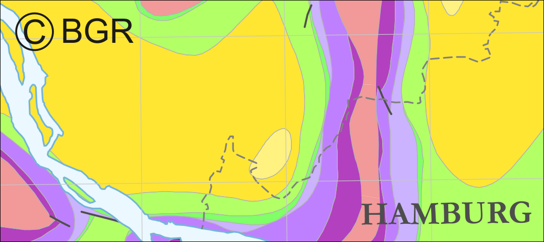
Horizontal cross-section maps display the geological situation at a given depth. In concurrence of maps at different depths areal bedding conditions can be determined, e.g. to generally assess and interpret the spread of different stratigraphic units. Clearly visible are extent and shape of the salt structures within their regional context at the different depths, with extent and boundary of the salt structures having been the main focus of the project. Four horizontal cross-section maps covering the whole onshore area of Northern Germany have been developed at a scale of 1:500.000. The maps cover the depths of -500, -1000, -1500, -2000 m below NN. The four depths were selected by the project partners and are based on typical depth requirements of existing salt caverns in Northern Germany, mainly related to hydrocarbon storage. The shapes of the structures show rudimentary information of their geometry and their change with depths. In addition they form the starting point for rock mechanical calculations necessary for the planning and construction of salt caverns for storage as well as for assessing storage potentials. The maps can be used as a pre-selection tool for subsurface uses. It can also be used to assess coverage and extension of salt structures. As, at the time of preparation of the maps, energy storage and cavern operation in offshore areas could not be assumed as a priority, such areas were not treated within the project. All horizontal cross-section maps were adjusted with the respective state geological survey organisations.
-
Geologische Karte 1:25 000 mit Erläuterungen, bestehend aus: Geologische Grundkarte 1:25 000, Profiltypenkarte des Quartär 1:25 000, Karte der Bohrprofile 1:25 000, Karte der präquartären Schichten und Lage der Quartärbasis 1:25 000, Übersichtskarte der Grundwassergleichen 1:50 000, Übersichtskarte der Bodengesellschaften 1:50 000, Übersichtskarte der geschützten Landschaftsteile sowie der ur- und frühgeschichtlichen Funde 1:50 000. Die Geologische Karte 1:25 000 liegt in analoger und digitaler Form sowie als Geodatendienst vor. Blatt 2426 Wandsbek wurde nur in digitaler Form veröffentlicht (CD).
-
Der Band Nr. 6 aus der Publikationsreihe „Fortschritte in der Geologie von Rheinland und Westfalen“ befasst sich mit den Sedimentabfolgen des Tertiärs, Juras, Zechsteins, Karbons und Devons im Bereich der Niederrheinischen Bucht. [1962. 462 S., 53 Abb., 14 Tab., 59 Taf.; ISBN 978-3-86029-820-6]
-
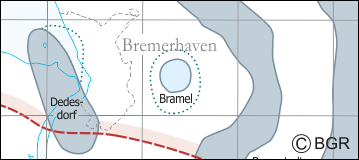
The application “Information System Salt Structures” provides information about the areal distribution of salt structures (stocks and pillows) in Northern Germany. With general structural describing information, such as depth, secondary thickness, types of use or state of exploration, queries can be conducted. Contours of the salt structures can be displayed at horizontal cross-sections at four different depths up to a maximum depth of 2000 m below NN. A data sheet with information and further reading is provided for every single salt structure. Taking into account the fact that this work was undertaken at a scale for providing an overview and not for investigation of single structures, the scale of display is limited to a minimum of 1:300.000. This web application is the product of a BMWi-funded research project “InSpEE” running from the year 2012 to 2015. The acronym stands for Information system salt structures: planning basis, selection criteria and estimation of the potential for the construction of salt caverns for the storage of renewable energies (hydrogen and compressed air)”.
-
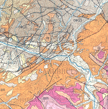
The map series General Geological Map of the Federal Republic of Germany 1:200,000 (GÜK200) is the result of cooperation between the State Geological Surveys of the Federal Republic of Germany (SGD), the Geological Surveys of neighbouring countries and the Federal Institute for Geosciences and Natural Resources (BGR). The GÜK200 displays the surface geology of Germany and adjacent areas of neighbouring countries on 55 map sheets. The map sheets show the regional dissemination of more than 3800 geological units. The geological units contain information on stratigraphy (age), genesis and petrography (composition) of the rocks.