 My GeoNetwork catalogue
Processed seismic data of Cruise BGR86 1986
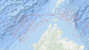
In the scope of International Geoscientific Programs and in close cooperation with PETRONAS, Malaysia, and in agreement with the Bureau of Mineral Resources (BMR) and the Bureau of Energy Development (BED), Manila, the Federal Institute for Geosciences and Natural Resources (BGR) carried out a geophysical survey on the continental margin off Sabah during the period from 20th July to 10th August, 1986, and in the Northwestern Sulu Sea during the period from 12th August to 28th August, 1986, using the PRAKLA-SEISMOS vessel EXPLORA chartered by the BGR. The research cruise is a continuation of BGR’s marine geoscientific studies in the South China Sea and in the Sulu Sea with the German research vessels VALDIVIA (1977), SONNE (1982/83) and EXPLORA (1984). The previous investigations provided new information regarding the geological and tectonic history of the southern part of the South China Sea in the context of plate tectonics. According to the interpretation of the large amount of geophysical, geological and geochemical data collected by BGR on previous cruises the widely accepted hypotheses of the presence of an ancient subduction zone beneath the Sabah-Palawan Trough has to be revised. The main objective of the EXPLORA cruise was to search for an Oligocene-Early Miocene carbonate platform off Sabah and in the western Sulu Sea. On the continental margin off Sabah 27 lines were surveyed with gravity and multichannel reflection seismics and partly with magnetics, with a total length of 3,126 km. A strong reflector interpreted as reflector BLUE of previous BGR cruises off Palawan was recognizable beneath the Sabah Trough in depth between 4 and 7 sec (TWT). The isochrones of the reflector strike approximately 50°N. The surface of the reflector dips with 2 to 3 degree towards southeast. Toward the north-western part of the Sabah Trough the reflector is disrupted by a basement high. According to the preliminary interpretation of the gravity data, the prominent free-air anomaly associated with the Sabah Trough and adjacent areas has the same shape as the anomaly observed across the Palawan Trough. Therefore it is concluded that the Sabah Trough is underlain by a thinned continental crust.
Simple
- Alternate title
-
BGR86 1986
- Date (Creation)
- 1986-07-28
- Citation identifier
- 787eafd9-002f-fa16-c967-3504665bc8da
- Status
- Completed
-
GEMET - INSPIRE themes, version 1.0
-
-
Geologie
-
geology
-
-
GEMET - Concepts, version 2.4
-
-
geophysics
-
Geophysik
-
raw material
-
Rohstoff
-
- Theme
-
-
Marine geology
-
Meeresgeologie
-
Seismics
-
Seismik
-
Two-dimensional seismic reflection
-
zweidimensionale Reflektionsseismik
-
- Place
-
-
South China Sea
-
Südchinesisches Meer
-
Sulu Sea
-
Sulu-See
-
Sabah Trough
-
Palawan Trough
-
- Access constraints
- Other restrictions
- Other constraints
- Es gelten keine Zugriffsbeschränkungen
- Use constraints
- Other restrictions
- Other constraints
-
Allgemeine Geschäftsbedingungen, siehe http://www.bgr.bund.de/AGB - General terms and conditions, see http://www.bgr.bund.de/AGB_en . Die bereitgestellten Informationen sind bei Weiterverwendung wie folgt zu zitieren: Datenquelle: BGR86 1986, (c) BGR, Hannover, 2019
- Spatial representation type
- Vector
- Language
- English
- Character set
- UTF8
- Topic category
-
- Geoscientific information
))
- Unique resource identifier
- EPSG:4326
- Distribution format
-
-
Shapefile
(
n/a
)
-
Shapefile
(
n/a
)
- Transfer size
- 2
- OnLine resource
-
BGR86 1986 (Shapefile)
BGR86 1986 im Format ESRI Shape
- OnLine resource
- Profile BGR86-01
- OnLine resource
- Profile BGR86-01A
- OnLine resource
- Profile BGR86-02
- OnLine resource
- Profile BGR86-03
- OnLine resource
- Profile BGR86-04
- OnLine resource
- Profile BGR86-05
- OnLine resource
- Profile BGR86-06
- OnLine resource
- Profile BGR86-07
- OnLine resource
- Profile BGR86-08
- OnLine resource
- Profile BGR86-09
- OnLine resource
- Profile BGR86-10
- OnLine resource
- Profile BGR86-11
- OnLine resource
- Profile BGR86-12
- OnLine resource
- Profile BGR86-13
- OnLine resource
- Profile BGR86-14
- OnLine resource
- Profile BGR86-15
- OnLine resource
- Profile BGR86-16
- OnLine resource
- Profile BGR86-18
- OnLine resource
- Profile BGR86-20
- OnLine resource
- Profile BGR86-21
- OnLine resource
- Profile BGR86-22
- OnLine resource
- Profile BGR86-23
- OnLine resource
- Profile BGR86-24
- OnLine resource
- Profile BGR86-25
- OnLine resource
- Profile BGR86-26
- OnLine resource
- Profile BGR86-27
- OnLine resource
- Profile BGR86-28
- OnLine resource
- Profile BGR86-30
- OnLine resource
- Profile BGR86-32
- OnLine resource
- Profile BGR86-33
- OnLine resource
- Profile BGR86-38
- OnLine resource
- Profile BGR86-40
- OnLine resource
- Profile BGR86-41
- OnLine resource
- Profile BGR86-44
- OnLine resource
- Profile BGR86-45
- OnLine resource
- Profile BGR86-46
- OnLine resource
- Profile BGR86-47
- OnLine resource
- Karte im BGR-Geoviewer
- Hierarchy level
- Dataset
Conformance result
- Date (Publication)
- 2010-12-08
- Explanation
-
siehe dazu die angegebene Durchführungsbestimmung
- Statement
-
In the period from 20th July to 10th August 1986 and from 12th August to 28th August 1986 BGR acquired seismic lines on the continental margin off Sabah and and in the Northwestern Sulu Sea during cruise BGR86 with SV EXPLORA. The lines BGR86-29, BGR86-31, BGR86-34, BGR86-35, BGR86-36, BGR86-39, BGR86-42 and BGR86-43 consist of raw data. The lines BGR86-01, BGR86-01A, BGR86-02, BGR86-03, BGR86-04, BGR86-05, BGR86-06, BGR86-07, BGR86-08, BGR86-09, BGR86-10, BGR86-11, BGR86-12, BGR86-13, BGR86-14, BGR86-15, BGR86-16, BGR86-18, BGR86-20, BGR86-21, BGR86-22, BGR86-23, BGR86-24, BGR86-25, BGR86-26, BGR86-27, BGR86-28, BGR86-30, BGR86-32, BGR86-33, BGR86-38, BGR86-40, BGR86-41, BGR86-44, BGR86-45, BGR86-46 and BGR86-47 are migrated data.
- File identifier
- bf3d6f93-446d-4e3a-abdc-650c39b95e93 XML
- Metadata language
- English
- Character set
- UTF8
- Parent identifier
-
Marine Seismic Survey Profiles (MSSP)
06a73c56-06a2-40d8-b806-466222b0760d
- Hierarchy level
- Dataset
- Hierarchy level name
-
Geophysik
- Date stamp
- 2023-11-16
- Metadata standard name
-
INSPIRE Metadata Implementing Rules: Technical Guidelines based on EN ISO 19115 and EN ISO 19119
- Metadata standard version
-
n/a
Overviews
Spatial extent
Provided by
