 My GeoNetwork catalogue
daily
Provided by
Type of resources
Available actions
Topics
Keywords
Contact for the resource
Update frequencies
-
The FQEN84 TTAAii Data Designators decode as: T1 (F): Forecast T1T2 (FQ): Other shipping A1A2 (EN): Northern Europe (Remarks from Volume-C: Nautical warning (IN ENGLISH))
-
The FQMM60 TTAAii Data Designators decode as: T1 (F): Forecast T1T2 (FQ): Other shipping A1A2 (MM): Mediterranean area (Remarks from Volume-C: WEATHER AND SEA BULLETIN FOR THE MEDITERRANEAN SEA (IN GERMAN))
-
The FQMM80 TTAAii Data Designators decode as: T1 (F): Forecast T1T2 (FQ): Other shipping A1A2 (MM): Mediterranean area (Remarks from Volume-C: WEATHER AND SEA BULLETIN FOR THE MEDITERRANEAN SEA (IN ENGLISH))
-
The FOEU40 TTAAii Data Designators decode as: T1 (F): Forecast T1T2 (FO): Guidance A1A2 (EU): Europe (Remarks from Volume-C: travel weather forecast north europe)
-
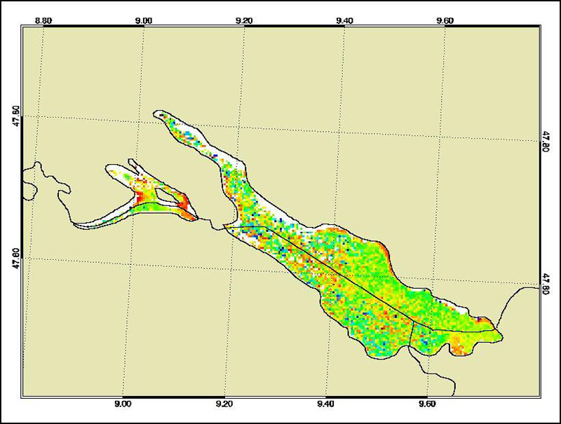
The Medium Resolution Imaging Spectrometer (MERIS) on Board ESA’s ENVISAT provides spectral high resolution image data in the visible-near infrared spectral region (412-900 nm) at a spatial resolution of 300 m. For more details on ENVISAT and MERIS see http://envisat.esa.int/ This product developed in the frame of the MAPP project (MERIS Application and Regional Products Projects) represents the chlorophyll concentration of Lake Constance derived from MERIS data. The product is a cooperative effort of DLR-DFD and the Institute for Coastal Research at the GKSS Research Centre Geesthacht. DFD pre-processed up to the value added level whenever MERIS data for the North Sea region was received and positively checked for a water area large enough for a suitable interpretation. For more details the reader is referred to http://wdc.dlr.de/sensors/meris/ and http://wdc.dlr.de/sensors/meris/documents/Mapp_ATBD_final_i3r0dez2001.pdf This product provides daily maps.
-
The product is automatically derived from Aqua/Terra (MODIS) satellite imagery in near-real time. It is an incremental product, meaning that the retrieved results are updated as soon as new input data becomes available over a timespan of ten days. Besides the fire perimeter and detection time, each feature contains information about the severity of the burning.
-
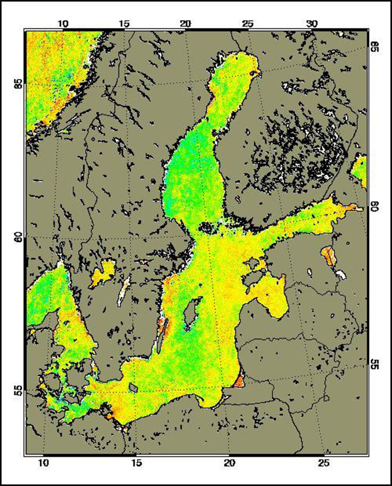
The Medium Resolution Imaging Spectrometer (MERIS) on Board ESA’s ENVISAT provides spectral high resolution image data in the visible-near infrared spectral region (412-900 nm) at a spatial resolution of 300 m. For more details on ENVISAT and MERIS see http://envisat.esa.int/ Spectral high resolution measurements allow to assess different water constituents in optically complex case-2 waters (IOCCG, 2000). The main groups of constituents are Chlorophyll, corresponding to living phytoplankton, suspended minerals or sediments and dissolved organic matter. They are characterised by their specific inherent optical properties, in particular scattering and absorption spectra. The Baltic Sea Water Constituents product was developed in a co-operative effort of DLR (Remote Sensing Technology Institute IMF, German Remote Sensing Data Centre DFD), Brockmann Consult (BC) and Baltic Sea Research Institute (IOW) in the frame of the MAPP project (MERIS Application and Regional Products Projects). The data are processed on a regular (daily) basis using ESA standard Level-1 and -2 data as input and producing regional specific value added Level-3 products. The regular data reception is realised at DFD ground station in Neustrelitz. For more details the reader is referred to http://wdc.dlr.de/sensors/meris/ and http://wdc.dlr.de/sensors/meris/documents/Mapp_ATBD_final_i3r0dez2001.pdf This product provides daily maps.
-
The FOEU37 TTAAii Data Designators decode as: T1 (F): Forecast T1T2 (FO): Guidance A1A2 (EU): Europe (Remarks from Volume-C: travel weather forecast west europe)
-
The FOEU41 TTAAii Data Designators decode as: T1 (F): Forecast T1T2 (FO): Guidance A1A2 (EU): Europe (Remarks from Volume-C: travel weather forecast south europe)
-
The FOEU39 TTAAii Data Designators decode as: T1 (F): Forecast T1T2 (FO): Guidance A1A2 (EU): Europe (Remarks from Volume-C: travel weather forecast east europe)