 My GeoNetwork catalogue
1 day
Provided by
Type of resources
Available actions
Topics
Keywords
Update frequencies
-
calculated values for potential Evaporation over gras at DWD stations in the Regional Basic Synoptic Network of the WMO, plus additional stations from the so called "Global Dataset" of DWD
-
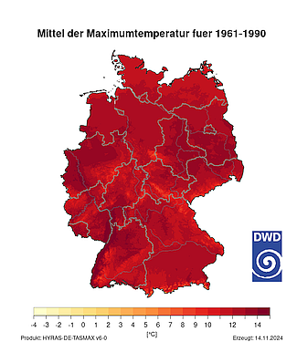
HYRAS-DE-TASMAX is a temperature product for Germany in a 1 km x 1 km grid for the period 1951 to the previous day and is based on daily measured maximum values of temperature. The data set can be used, for example, for the analysis of past climate, for bias adjustment of regionalized climate projection data and as input data for hydrological modeling.
-
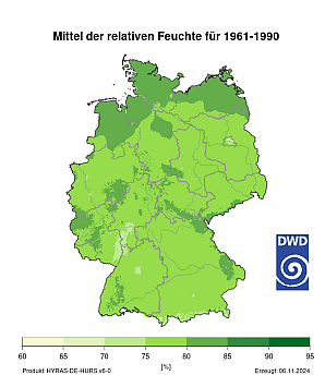
HYRAS-DE-HURS is a relative humidity product for Germany in a 1 km x 1 km grid for the period 1951 to the previous day and is based on daily measured values of relative humidity. The data set can be used, for example, for the analysis of past climate, for bias adjustment of regionalized climate projection data and as input data for hydrological modeling.
-
The daily grids of soil moisture are calculated for 10 cm layers up to a depth of 2 meters and for predefined layer thicknesses of 0-30, 0-60 and 0-90 cm for three different agricultural crops using the AMBAV 2.0 V1.5 model. The meteorological data required for the calculation input fields must be in hourly resolution and are provided by interpolated weather station data. Furthermore, the model with soil information from the soil guide profiles of the usage-differentiated soil overview map (BÜK 1000 N) parameterized by the Federal Institute for Geosciences and Natural Resources (BGR). If the type of soil is the same, the soils differ depending on their use. In addition, the depth of the soil and the skeletal content (coarse soil > 2 mm) in the various soil layers are taken into account. The data has a spatial resolution of 1 x 1 km and is completely comprehensive Germany from. Data outside of Germany or in settlement areas with sealed areas have an incorrect identifier -9999. All information about the grid is stored in the metadata of the netcdf file.
-
HYRAS-DE-TASMAX is a temperature product for Germany in a 1 km x 1 km grid for the period 1951 to the previous day and is based on daily measured maximum values of temperature. The data set can be used, for example, for the analysis of past climate, for bias adjustment of regionalized climate projection data and as input data for hydrological modeling.
-
HYRAS-DE-HURS is a relative humidity product for Germany in a 1 km x 1 km grid for the period 1951 to the previous day and is based on daily measured values of relative humidity. The data set can be used, for example, for the analysis of past climate, for bias adjustment of regionalized climate projection data and as input data for hydrological modeling.
-
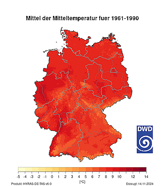
HYRAS-DE-TAS is a temperature product for Germany in a 1 km x 1 km grid for the period 1951 to the previous day and is based on daily measured temperature mean values. The data set can be used, for example, for the analysis of past climate, for bias adjustment of regionalized climate projection data and as input data for hydrological modeling.
-
The daily grids of soil moisture are calculated for 10 cm layers up to a depth of 2 meters and for predefined layer thicknesses of 0-30, 0-60 and 0-90 cm for three different agricultural crops using the AMBAV 2.0 V1.5 model. The meteorological data required for the calculation Input fields must be in hourly resolution and are provided by interpolated weather station data. Furthermore, the model with soil information from the soil guide profiles of the usage-differentiated soil overview map (BÜK 1000 N) parameterized by the Federal Institute for Geosciences and Natural Resources (BGR). If the type of soil is the same, the soils differ depending on their use. In addition, the depth of the soil and the skeletal content (coarse soil > 2 mm) in the various soil layers are taken into account. The data has a spatial resolution of 1 x 1 km and is completely comprehensive Germany from. Data outside of Germany or in settlement areas with sealed areas have an incorrect identifier -9999. All information about the grid is stored in the metadata of the netcdf file.
-
The daily grids of soil moisture are calculated for 10 cm layers up to a depth of 2 meters for selected agricultural crops with the AMBAV 2.0 model. The meteorological input fields required for the calculation must be available in hourly resolution and derived from interpolated weather station data. Furthermore, the model is parameterized with soil information from the soil guide profiles of the Bodenübersichtskarte (BÜK 1000) of the Federal Institute for Geosciences and Natural Resources (Geowissenschaftenund Rohstoffe, BGR). The data have a spatial resolution of 1 x 1 km and cover the whole of Germany. Data outside of Germany are considered as missing values.