 My GeoNetwork catalogue
Ackerland
Provided by
Type of resources
Available actions
Topics
Keywords
Update frequencies
Service types
-

-

-

-
Gefördert wird der Erhalt von Brut-, Nahrungs- oder Rückzugsflächen für Vogel- und Tierarten der Agrarlandschaft auf Ackerland, insbesondere für den Feldhamster.
-
Gefördert wird der Erhalt von Brut-, Nahrungs- oder Rückzugsflächen für Vogel- und Tierarten der Agrarlandschaft auf Ackerland, insbesondere für den Rotmilan.
-
Der Kartendienst (WMS-Gruppe) stellt die Geodaten der Hangneigung bei Acker- und Grünland ab 20% dar.:Hangneigung bei Acker- und Grünland ab 20%
-
Gefördert wird der Erhalt von Brut-, Nahrungs- oder Rückzugsflächen für Vogel- und Tierarten der Agrarlandschaft auf Ackerland, insbesondere für den Ortolan.
-

Der Dienst beinhaltet die Bodenrichtwerte und die dazugehörigen Flächen (Bodenrichtwertzonen) im Landkreis Mecklenburgische Seenplatte ab dem 01.01.2026 sowie weitere allgemeine und wertbeeinflussende Merkmale der Bodenrichtwerte. Die Daten liegen nach dem Datenmodell BORIS.MV3 vor, das auf dem Datenmodell VBORIS3 basiert.
-
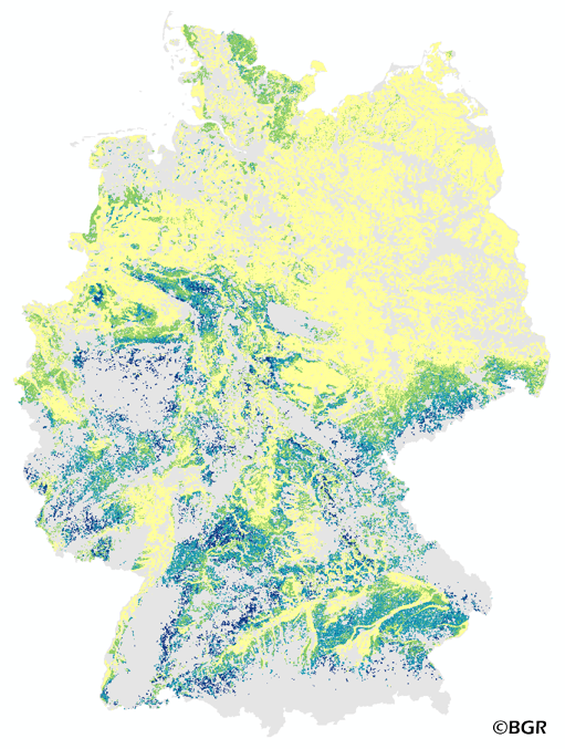
The map of the direct runoff on agricultural soils gives an overview of the average annual amount of precipitation, which does not infiltrate into the soils. It is based on pedological, relief and climatic factors. The map was created by using the empirical SCS – runoff curve number approach. The method was adapted by the Federal Institute for Geosciences and Natural Resources (BGR) as part of the attempt to model the seepage volume in the TUB_BGR method. The land use stratified soil map of Germany at scale 1:1,000,000 was used as pedological input to the model. The relief data was derived from the DEM50 of the BKG. The mean annual precipitation data of the period 1961 -1990 (DWD) is used as an input as well. The land use information is derived from CORINE Land Cover data set (2006).
-
Der Kartendienst (WMS-Gruppe) stellt die Geodaten der Hangneigung bei Acker- und Grünland ab 20% dar.:Der Kartendienst stellt die Geodaten der Hangneigung bei Acker- und Grünland ab 20% dar.