 My GeoNetwork catalogue
Labrador Sea
Provided by
Type of resources
Available actions
Topics
Keywords
Contact for the resource
Service types
-
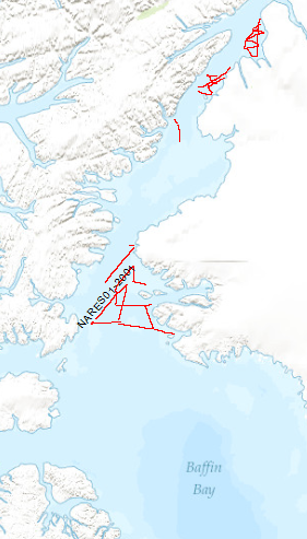
The Scientific staff and crew onboard CCGS Louis S. St. Laurent (LSL) returned September the 10th, 2001 from a scientific expedition to the Nares Strait, the northernmost waterway connecting the Arctic and Atlantic oceans. The data format is Society of Exploration Geophysicists SEG Y. The ice conditions in the strait required the support of Canada's largest ice breaker. The ship was a versatile platform for 34 scientists to accomplish their marine investigation. The LSL has a history of supporting international scientific expeditions including an oceanographic transect of the Arctic Ocean in 1994 and a biological study of the Canadian Arctic Islands in 1999. Germany (Bundesanstalt für Geowissenschaften und Rohstoffe, BGR) and Canada (Geological Survey of Canada) undertook a 5-week scientific cruise to study and explore the geological structure and evolution of the Nares Strait. The primary objective was the study of structural features relating to the formation of the Arctic Ocean and, in particular, the study of the Wegener Fault. This fault is a linear boundary between Greenland and Ellesmere Island which was noted by the German scientist Alfred Wegener in 1915 and later became the subject of a major scientific controversy. The co-operative cruise, which was planned over a period of 2 years, provided the basis for a wide range of scientific investigations, from marine seismic work and climate change studies through airborne magnetic investigations to geodetic survey measurements and geological sampling onshore. Systematic geophysical offshore studies in this key area had not been undertaken before. Where towing of seismic equipment was not possible because of ice coverage, magnetic maps were made using a helicopter-borne magnetic sensor system. Sediment and water samples taken during the cruise provide information on changes in climate and sea ice cover from the last ice-age to the present. An 11 m-long sediment core from outer Jones Sound is the longest core ever taken in the Canadian Arctic channels and holds clues to the detailed climate history of northern Baffin Bay.
-
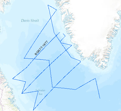
A geophysical reconnaissance survey was carried out in the Labrador Sea and Davis Strait between July and September 1977 by BGR. The data format is Society of Exploration Geophysicists SEG Y. The survey was executed on the research vessel MS Explora. The seismic, magnetic and gravity data from 5931 line-kilometers on 21 lines were recorded on magnetic tape. A 24-fold coverage technique was used with 48 seismic channels (traces), with a 2400m streamer cable, and 23.45 l airgun array. A full integrated computerized satellite navigation system (INDAS III) served as positioning system. Based on a preliminary interpretation of the seismograms, the Labrador Sea was devided into an eastern (Greenland) and western (Canadian) area, seperated by the Mid Labrador Ridge. Within the eastern part of the Labrador Sea the Pre-Cenozoic sediments show three distinct layers, traceable over the entire Greenland area of the sea. In the Cenozoic layer olisthostromes occur. The highest apparent velocity determined from sonobuoy data was 9.26 km/sec. The calculated refractor lies at a depth of approximately 13 km. The seismic section from the sediments on the Canadian side of the Labrador Sea show a uniform series of thick sediments below the Cenozoic cover. The highly disturbed basement is often masked by the multiple reflections from the seafloor. Statements about the nature and structure of the basement can only be made after processing data.
-
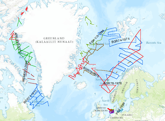
During the period from 1974 to 2018 various cruises from BGR acquired seismic lines worldwide. The aim of these marine expeditions was a detailed survey of the geological structure.
-
During the period from 1974 to 2023 various cruises from BGR acquired seismic lines worldwide. The aim of these marine expeditions were a detailed survey of the geological structure of seabed.