 My GeoNetwork catalogue
Salzstock
Provided by
Type of resources
Available actions
Keywords
Contact for the resource
Update frequencies
Service types
-
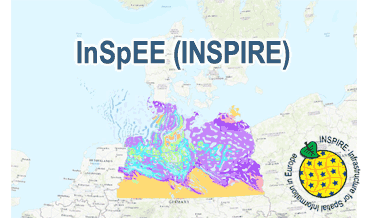
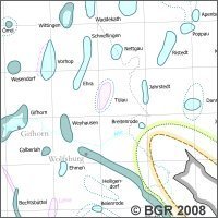
The WMS InSpEE (INSPIRE) provides information about the areal distribution of salt structures (salt domes and salt pillows) in Northern Germany. Contours of the salt structures can be displayed at horizontal cross-sections at four different depths up to a maximum depth of 2000 m below NN. The geodata have resulted from a BMWi-funded research project “InSpEE” running from the year 2012 to 2015. The acronym stands for "Information system salt structures: planning basis, selection criteria and estimation of the potential for the construction of salt caverns for the storage of renewable energies (hydrogen and compressed air)”. Taking into account the fact that this work was undertaken at a scale for providing an overview and not for investigation of single structures, the scale of display is limited to a minimum of 1:300.000. Additionally four horizontal cross-section maps display the stratigraphical situation at a given depth. In concurrence of maps at different depths areal bedding conditions can be determined, e.g. to generally assess and interpret the spread of different stratigraphic units. Clearly visible are extent and shape of the salt structures within their regional context at the different depths, with extent and boundary of the salt structures having been the main focus of the project. Four horizontal cross-section maps covering the whole onshore area of Northern Germany have been developed at a scale of 1:500.000. The maps cover the depths of -500, -1000, -1500, -2000 m below NN. The four depths are based on typical depth requirements of existing salt caverns in Northern Germany, mainly related to hydrocarbon storage. The shapes of the structures show rudimentary information of their geometry and their change with depths. In addition they form the starting point for rock mechanical calculations necessary for the planning and construction of salt caverns for storage as well as for assessing storage potentials. The maps can be used as a pre-selection tool for subsurface uses. It can also be used to assess coverage and extension of salt structures. Offshore areas were not treated within the project. All horizontal cross-section maps were adjusted with the respective state geological survey organisations. According to the Data Specification on Geology (D2.8.II.4_v3.0) the WMS InSpEE (INSPIRE) provides INSPIRE-compliant data. The WMS InSpEE (INSPIRE) contains two group layers: The first group layer “INSPIRE: Salt structures in Northern Germany“ comprises the layers GE.Geologic.Unit.Salt structure types, GE.GeologicUnit.Salt pillow remnants, GE.GeologicUnit.Structure-building salinar and GE.GeologicUnit.Structural outlines. The layer GE.GeologicUnit.Structural outlines contains according to the four depths four sublayers, e.g. GE.GeologiUnit.Structural outlines 500 m below NN. The second group layer „INSPIRE: Horizontal cross-section maps of Northern Germany“ comprises according to the four depths four layers, e.g. Horizontal cross-section map – 500 m below NN. This layer, in turns, contains two sublayers: GE.GeologicFault.Relevant fault traces and GE.GeologicUnit.Stratigraphic Units. Via the getFeatureInfo request the user obtains additional information on the different geometries. In case of the GE.Geologic.Unit.Salt structure types the user gets access to a data sheet with additional information and further reading in German for the respective salt structure via the getFeatureInfo request.
-
Enspricht inhaltlich der vom Geologischen Dienst M-V 1997 herausgegebenen Übersichtskarte 1:500 000 "Zechsteinsalzstrukturen".
-
New map of salt structures in northern Germany at a scale of 1:500,000.
-
Horizontal cross-section maps display the geological situation at a given depth. In concurrence of maps at different depths areal bedding conditions can be determined, e.g. to generally assess and interpret the spread of different stratigraphic units. Clearly visible are extent and shape of the salt structures within their regional context at the different depths, with extent and boundary of the salt structures having been the main focus of the project. Four horizontal cross-section maps covering the whole onshore area of Northern Germany have been developed at a scale of 1:500.000. The maps cover the depths of -500, -1000, -1500, -2000 m below NN. The four depths were selected by the project partners and are based on typical depth requirements of existing salt caverns in Northern Germany, mainly related to hydrocarbon storage. The shapes of the structures show rudimentary information of their geometry and their change with depths. In addition they form the starting point for rock mechanical calculations necessary for the planning and construction of salt caverns for storage as well as for assessing storage potentials. The maps can be used as a pre-selection tool for subsurface uses. It can also be used to assess coverage and extension of salt structures. As, at the time of preparation of the maps, energy storage and cavern operation in offshore areas could not be assumed as a priority, such areas were not treated within the project. All horizontal cross-section maps were adjusted with the respective state geological survey organisations.
-
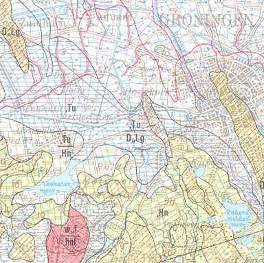
The map series General Geological Map of the Federal Republic of Germany 1:200,000 (GÜK200) is the result of cooperation between the State Geological Surveys of the Federal Republic of Germany (SGD), the Geological Surveys of neighbouring countries and the Federal Institute for Geosciences and Natural Resources (BGR). The GÜK200 displays the surface geology of Germany and adjacent areas of neighbouring countries on 55 map sheets. The map sheets show the regional dissemination of more than 3800 geological units. The geological units contain information on stratigraphy (age), genesis and petrography (composition) of the rocks.
-
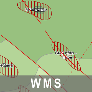
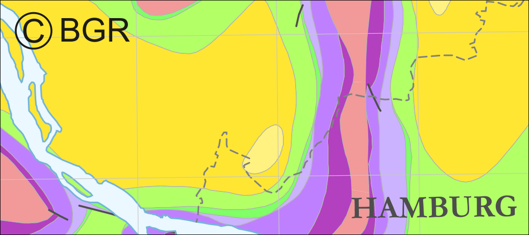
Der Darstellungsdienst (WMS) Strukturgeologische Übersicht Brandenburg stellt Daten zur Strukturgeologische Übersicht bereit. Dieser wird dominiert durch die NW-SE streichende intrakratonale Norddeutsche Senke, deren Basis sich im nördlichen und mittleren Teil des Landesterritoriums auf über 5 000 m Tiefe absenkt und nach Süden und Südosten heraushebt. Das Beckenzentrum setzt sich von Nordwest-Brandenburg in Richtung Unterelbe fort. Dagegen ist die jetzige südliche Begrenzung tektonisch bedingt. Die strukturgeologischen Verhältnisse werden durch die jetzige Tiefenlage der Zechsteinbasis und die strukturelle Modulierung der Zechsteinoberfläche wiedergegeben. Weitere Informationen unter: https://geo.brandenburg.de/karten/htdocs/salinar.pdf. Die Strukturgeologische Übersicht Brandenburg gehört thematisch zu der Rohstoff- und Tiefengeologie. Diesem Thema sind zwei weitere Dienstethemen zugeorndet: - WMS/WFS/WCS Reflexionsseismische Horizonte 2D BB, - WMS/WFS Karte der oberflächennahen Rohstoffe 1: 50 000 BB. Der WMS beinhaltet die folgenden Layer: - Beschriftungen Störungen [bstoerungen], - Beschriftungen Blöcke [bbloecke], - Störungen [stoer], - Diapir [diapir], - Kissen [kissen], - Zechstein [zechstein].
-
Dokumente zur Höffigkeit von nutzbaren Kali- und Steinsalzlagerstätten im Bundesland Mecklenburg-Vorpommern - vorwiegend in SW-Mecklenburg -. Dokumentationen zum Abbau von Kalisalzen in den ehemaligen Kalischachtanlagen in Conow und Lübtheen sowie Unterlagen zum bergschadenskundlichen Status sowie zur Verwahrung dieser Schachtanlagen.
-
The map series General Geological Map of the Federal Republic of Germany 1:200,000 (GÜK200) is the result of cooperation between the State Geological Surveys of the Federal Republic of Germany (SGD), the Geological Surveys of neighbouring countries and the Federal Institute for Geosciences and Natural Resources (BGR). The GÜK200 displays the surface geology of Germany and adjacent areas of neighbouring countries on 55 map sheets. The map sheets show the regional dissemination of more than 3800 geological units. The geological units contain information on stratigraphy (age), genesis and petrography (composition) of the rocks.
-
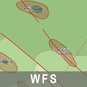
Der Downloaddienst (WFS) Strukturgeologische Übersicht Brandenburg stellt Daten zur Strukturgeologische Übersicht bereit. Dieser wird dominiert durch die NW-SE streichende intrakratonale Norddeutsche Senke, deren Basis sich im nördlichen und mittleren Teil des Landesterritoriums auf über 5 000 m Tiefe absenkt und nach Süden und Südosten heraushebt. Das Beckenzentrum setzt sich von Nordwest-Brandenburg in Richtung Unterelbe fort. Dagegen ist die jetzige südliche Begrenzung tektonisch bedingt. Die strukturgeologischen Verhältnisse werden durch die jetzige Tiefenlage der Zechsteinbasis und die strukturelle Modulierung der Zechsteinoberfläche wiedergegeben. Weitere Informationen unter: https://geo.brandenburg.de/karten/htdocs/salinar.pdf. Die Strukturgeologische Übersicht Brandenburg gehört thematisch zu der Rohstoff- und Tiefengeologie. Diesem Thema sind zwei weitere Dienstethemen zugeorndet: - WMS/WFS/WCS Reflexionsseismische Horizonte 2D BB, - WMS/WFS Karte der oberflächennahen Rohstoffe 1: 50 000 BB. Der WFS beinhaltet die folgenden FeatureTypes: - Störungen [app:stoer], - Diapir [app:diapir], - Kissen [app:kissen], - Zechstein [app:zechstein].