 My GeoNetwork catalogue
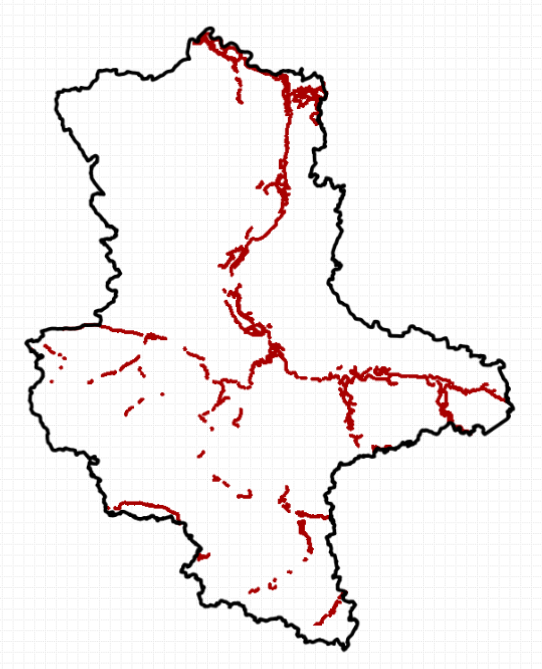
flooding
Provided by
Type of resources
Available actions
Topics
Keywords
Update frequencies
Service types
-
-
Der interoperable INSPIRE-WFS ist ein Downloaddienst, der Daten im INSPIRE-Zielschema Boden (abgeleitet aus dem originären Datensatz: Retentionsflächen Überschwemmung Brandenburg) bereitstellt. Er gibt einen Überblick über die Retentionspotenziale der Böden bei Überschwemmungen in Brandenburg. Diese Karte basiert auf den Legendeneinheiten der Bodenübersichtskarte (BÜK300) und der je Legendeneinheit dargestellten Bodenformengesellschaft. Folgende Böden der Legendeneinheiten wurden in der Karte berücksichtigt: (1) Gleyböden in holozänen Auen mit hohem Retentionspotenzial, (2) überwiegend Gleyböden mit hohem Retentionspotenzial, (3) überwiegend vergleyte Böden mit teilweisem Retentionspotenzial, (4) Flächen mit überwiegend verbreiteten Niedermoorböden meist in Niederungsgebieten, (0) keine retentionsrelevanten Böden. Gemäß der INSPIRE-Datenspezifikation für Soil liegen die Inhalte INSPIRE-konform vor. Der WFS beinhaltet die folgenden FeatureTypes: - Beobachtungsprozess (ompr:Process) mit Angaben zu der am Prozess beteiligten Organisation LBGR, - abgeleitetes Bodenobjekt (so:SoilDerivedObject) mit Angaben zur Beobachtung der Bodeneigenschaft zur Beschreibung des abgeleiteten Bodenobjekts, - Beobachtung einer Bodeneigenschaft (om:OM_Observation) mit Angaben zum Charakter des vom Boden abgeleiteten Objekts, der beobachteten Eigenschaft, der vom Boden abgeleiteten Beobachtung bodenbezogene Eigenschaften (retentionPotential), dem Ergebnis der Beobachtungen des abgeleiteten Bodenobjekts, - Bodenkörper (so:SoilBody), abgegrenzter und hinsichtlich bestimmter Bodeneigenschaften und/oder räumlicher Muster homogener Teil der Bodendecke, und - Bodenschicht (so:SoilLayer) mit Angaben zur Zuordnung der Schicht zu einem ihrer Art entsprechenden Begriff, zum abgeleiteten Profil (so:DerivedSoilProfile), das als Referenzprofil für eine bestimmte Art von Boden in einem bestimmten geografischen Gebiet dient, der oberen und unteren Tiefe des Profilelements, gemessen von der Oberfläche (0 cm) eines Bodenprofils (in cm). --- The compliant INSPIRE-WFS is a download service that delivers data in the INSPIRE target schema Soil (derived from the original data set: Flood retention areas Brandenburg). It provides an overview of the retention potentials of soils during floods in the State of Brandenburg. This map is based on the legend units of the soil map (BÜK300) and the soil forms represented per legend unit. The following soils of the legend units were considered in the map: (1) Gley soils in holocene floodplains with high retention potential, (2) predominantly Gley soils with high retention potential, (3) predominantly gleyic soils with partial retention potential, (4) areas with predominantly widespread peat soils mostly in lowland areas, (0) no retention-relevant soils. The content is compliant to the INSPIRE Data Specification on Soil. The WFS includes the following feature types: - Observation process (ompr:Process) with information about the organization LBGR involved in the process, - Soil derived object (so:SoilDerivedObject) with information on the observation of the soil property for characterizing the soil derived object, - Observations of a soil derived object (om:OM_Observation) with information about the character of the soil derived object, the observed property, the soil derived observation of soil related properties (retentionPotential), the result of the observations of the soil derived object, - Soil body (so:SoilBody), part of the soil cover that is delineated and that is homogeneous with regard to certain soil properties and/or spatial patterns, and - Soil layer (so:SoilLayer) with information about the assignation of the layer according to the concept that fits its kind, to the derived soil profile (so:DerivedSoilProfile), which serves as a reference profile for a particular type of soil in a specific geographical area, including the upper and lower depth of the profile element from the surface (0 cm) of a soil profile (in cm).
-

Der interoperable INSPIRE-Datensatz beinhaltet Daten vom LBGR über die Retentionspotenziale der Böden bei Überschwemmungen Brandenburg, transformiert in das INSPIRE-Zielschema Boden. Der Datensatz wird über je einen interoperablen Darstellungs- und Downloaddienst bereitgestellt. --- The compliant INSPIRE data set contains data about the retention potentials of flooding in the State of Brandenburg from the LBGR, transformed into the INSPIRE target schema Soil. The data set is provided via compliant view and download services.
-
Der interoperable INSPIRE-WMS ist ein Darstellungsdienst, der Daten im INSPIRE-Zielschema Boden (abgeleitet aus dem originären Datensatz: Retentionsflächen Überschwemmung Brandenburg) bereitstellt. Er gibt einen Überblick über die Retentionspotenziale der Böden bei Überschwemmungen in Brandenburg. Diese Karte basiert auf den Legendeneinheiten der Bodenübersichtskarte (BÜK300) und der je Legendeneinheit dargestellten Bodenformengesellschaft. Folgende Böden der Legendeneinheiten wurden in der Karte berücksichtigt: (1) Gleyböden in holozänen Auen mit hohem Retentionspotenzial, (2) überwiegend Gleyböden mit hohem Retentionspotenzial, (3) überwiegend vergleyte Böden mit teilweisem Retentionspotenzial, (4) Flächen mit überwiegend verbreiteten Niedermoorböden meist in Niederungsgebieten, (0) keine retentionsrelevanten Böden. Gemäß der INSPIRE-Datenspezifikation für Soil liegen die Inhalte INSPIRE-konform vor. Der WMS beinhaltet die folgenden Layer: - SO.retentionPotential: Retentionsflächen Überschwemmung beschreibt das Potential von Flächen zur Verringerung und Verzögerung des Abflussgeschehens während Überflutungsereignissen. - SO.SoilBody: Abgegrenzter und hinsichtlich bestimmter Bodeneigenschaften und/oder räumlicher Muster homogener Teil der Bodendecke. --- The compliant INSPIRE-WMS is a view service that delivers data in the INSPIRE target schema Soil (derived from the original data set: Flood retention areas Brandenburg). It provides an overview of the retention potentials of soils during floods in the State of Brandenburg. This map is based on the legend units of the soil map (BÜK300) and the soil forms represented per legend unit. The following soils of the legend units were considered in the map: (1) Gley soils in holocene floodplains with high retention potential, (2) predominantly Gley soils with high retention potential, (3) predominantly gleyic soils with partial retention potential, (4) areas with predominantly widespread peat soils mostly in lowland areas, (0) no retention-relevant soils. The content is compliant to the INSPIRE Data Specification on Soil. The WMS includes the following layers: - SO.retentionPotential: Retention flooding areas indicates the potential of areas near river systems to retain water during flood events. - SO.SoilBody: Part of the soil cover that is delineated and that is homogeneous with regard to certain soil properties and/or spatial patterns.