 My GeoNetwork catalogue
world
Provided by
Type of resources
Available actions
Topics
Keywords
Contact for the resource
Update frequencies
Service types
-
-
-
-
-
-
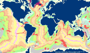
The General Global Map of Seafloor Bedrock Geology (seafloorgeol) shows the global distribution of seafloor bedrock, the boundaries of the continental shelf and continental slope, the axes of the oceanic ridges and other marine geological features. Sedimentary deposits are not shown. The map is based on extracts from Bouysse et al. (2010) © CGMW, and Bryan & Ernst (2008) using Esri Basemap, HERE, Garmin, FAO, NOAA, USGS, © OpenStreetMap contributors and the GIS User Community.
-
The Global Precipitation Climatology Centre (GPCC) has been established in 1989 on request of the World Meteorological Organization (WMO). It is operated by Deutscher Wetterdienst (DWD, National Meteorological Service of Germany) as a German contribution to the World Climate Research Programme (WCRP). Mandate of the GPCC is the global analysis of precipitation on earth’s land surface based on in situ rain gauge data. These gridded analyses provide long-term means, monthly and daily totals, quantiles and a drought index.
-
Free access and download to of a growing selection of DWD’s climate data. Via CDC Search you will find data for direct download and interactive access to station data. The interactive mode gives graphical and tabular previews of the German station data. In addition, all data sets remain accessible from our ftp server for direct download
-
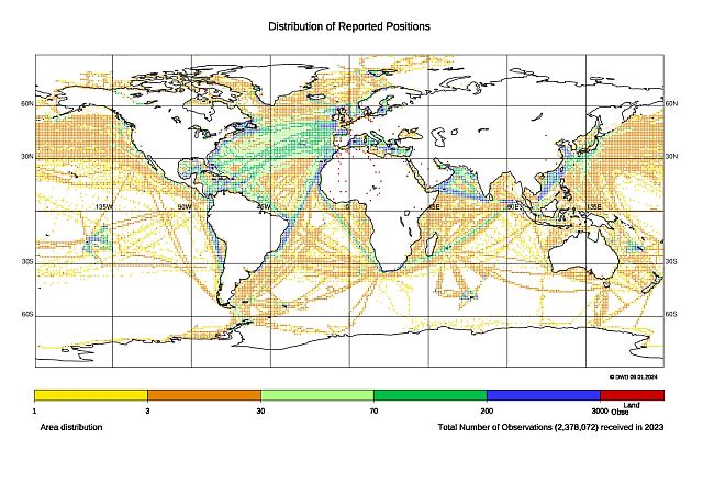
Mqc data files contain all worldwide weather reports of the Voluntary Observing Ships (VOS) that are internationally exchanged via the Voluntary Observing Ship Global Data Assembly Centres (VOS-GDACs) on a quarterly basis. This delayed mode data is checked according to the Minimum Quality Control Standard (MQCS) and provided with quality control indicators, the flags. The data format is International Maritime Meteorological Tape (IMMT) and from 2010 on also International Maritime Meteorological Archive (IMMA).