 www.geodatenkatalog.de (S2F)
Provided by
Type of resources
-
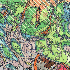
The International Geological Map of Europe and the Mediteranean Regions 1 : 1 500 000 ("Carte Géologique Internationale de l'Europe et des Régions Méditerranéennes 1 : 1 500 000") shows the geology of the European continent from the Ural mountains in the east up to Island in the west and the whole mediteranean region in the south. The geology is differenciated in stratigraphy, igneous and metamorphic rocks. In addition there are two legend sheets and a title sheet. The language of the series is French.
-
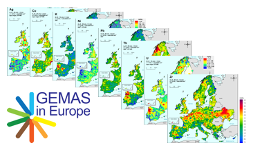
GEMAS (Geochemical Mapping of Agricultural and Grazing Land Soil in Europe) is a cooperative project between the Geochemistry Expert Group of EuroGeoSurveys and Eurometeaux. In total, more than 60 international organisations and institutions worldwide were involved in the implementation of the project. During 2008 and 2009, a total of 2219 samples of agricultural (arable land soils, 0 – 20 cm, Ap samples) and 2127 samples of grazing land (pasture land soils, 0 – 10 cm, Gr samples) soil were collected at a density of 1 site/2 500 km² each from 33 European countries, covering an area of 5,600,000 km². All samples were analysed for 52 chemical elements after an aqua regia extraction, 41 by XRF (total), TC and TOC. In addition, the agricultural soil samples were analysed for 57 elements in a mobile metal ion (MMI®) extraction and Pb isotopes. All analytical results were subject to tight external quality control procedures. The GEMAS project thus provides for the first time fully harmonised data for element concentrations and bioavailability of the elements at the continental (European) scale. The downloadable files present the areal distribution of the element contents determined by different analytical methods in the shape of colour shaded contour maps with a classification in 7 and 72 levels each.
-
The International Map of the Iron Ore Deposits of Europe 1 : 2.500.000 completed in 1977 is published by the Federal Institute for Geosciences and Natural Resources (BGR) About 70 geoscientists from Europe, North Africa, Eastern Europe and Middle East collaborated with the Editorial Staff in the compilation of the map and the Editorial Notes. More than 800 iron ore deposits are represented on the map which covers 42 countries in 16 map sheets. All deposits of importance, either actually being mined or recently abandoned, are included. Deposits of only genetic or historic interest are also shown. Detailed information on the Map of Iron Ore Deposits of Europe - to its structure, arrangement and background data - can be found in the Explanatory Notes to the Map
-
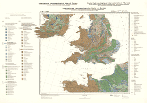
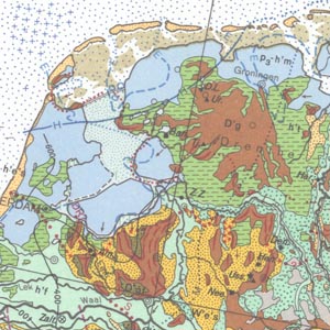
The International Hydrogeological Map of Europe, scale 1:1,500,000 is a series of general hydrogeological maps comprising 25 map sheets with explanatory notes, covering the whole European continent and parts of the Near East. The national contributions to this map series were compiled by hydrogeologists and experts in related sciences of the countries concerned under the auspices of the International Association of Hydrogeologists (IAH) and its Commission on Hydrogeological Maps (COHYM). The project is supported by the Commission for the Geological Map of the World (CGMW).The scientific editorial work is supported financially by the Government of the Federal Republic of Germany through the Bundesanstalt für Geowissenschaften und Rohstoffe (BGR) and by the United Nations Educational, Scientific and Cultural Organization (UNESCO). These organizations are responsible for the cartography, printing and publication of the map sheets and explanatory notes.The series of hydrogeological maps seeks to represent the hydrogeological setting of Europe as a whole without regard to political boundaries. Together with the information presented in the accompanying explanatory notes, the map can be used for scientific purposes, for large-scale regional planning and as a basis for detailed hydrogeological mapping.
-
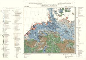
The idea to represent the main features of the European Quaternary was first discussed at the Second Congress of the International Union for Quaternary Research (INQUA) held in Leningrad (St. Petersburg) in 1932. Compiled by the Federal Institute for Geosciences and Natural Resources (BGR) in cooperation with the INQUA, the International Quaternary Map of Europe 1 : 2.500.000 was finished in 1995. It is jointly published by the BGR and UNESCO. Several Quaternary features such as end moraines, ground moraine hillocks, kames, drumlins, eskers and ice border lines are represented on the map. Additionally, the map shows the directions of ice movements, limits of marine transgressions and tectonic faults. Important localities of Quaternary discovery relating to both geology and prehistory, bathymetric lines and recent deposits covering the sea floor are also indicated as well. The legend on each of the 14 map sheets is in German and, depending on the territories covered, in English, French or Russian. The general legend is placed on map sheet number 15.
-
Informationen über aktuelle und geplante Baustellen mit starker oder leichter Beeinträchtigung.