 My GeoNetwork catalogue
Keyword
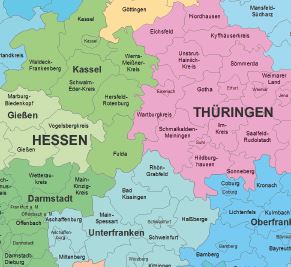
Boundaries
Provided by
Type of resources
Available actions
Topics
Keywords
Contact for the resource
Update frequencies
From
1
-
10
/
216
-
-

-
Märkischer Kreis ALKIS-Daten ohne Eigentümer NAS+Shape Der ALKIS Bestandsdatenauszug ohne Eigentümer aus dem Liegenschaftskataster enthält für Flurstücke und Gebäude Geobasisdaten in beschreibender und darstellender Form. Für alle Flurstücke weist das Liegenschaftskataster deren Form, Lage, Nutzung, Größe, Bebauung und charakteristische Topographie nach. Es enthält auch die Ergebnisse der Bodenschätzung.
-
-
-
-

-
-

-
