 My GeoNetwork catalogue
Barentssee
Provided by
Type of resources
Available actions
Topics
Keywords
Contact for the resource
Service types
-
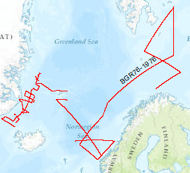
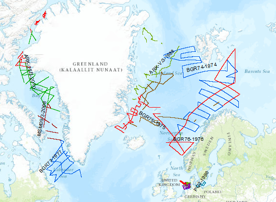
On the MS Explora (1st September, 1976 - 29th September, 1976) multichannel seismic measurements were carried out on 44 lines The area covered was the Barentssea. The data format is Society of Exploration Geophysicists SEG Y.
-
The PANORAMA-2 research cruise was carried out between August 15th and September 20th 2015 aboard the Italian research vessel OGS Explora, like the PANORAMA-1 cruise in 2013. The intended survey area was the European sector of the Arctic east and southeast of the Svalbard archipelago in the area of the northern Barents Sea. Main target of the PANORAMA-2 cruise was the acquisition of new geophysical data and the probing of surficial sediments in the underexplored area of the Sørkapp Basin and Olga Basin. In the course of the 20 day lasting Leg1 of the PANORAMA-2 cruise geophysical data acquisition was carried out. About 1750 km of 2D multi-channel seismic data were acquired and about 350 km of wide angle seismic data by means of sonobuoys. Sediment echosounder data, multi-beam data, gravity data and geomagnetic data were acquired during the entire cruise in a 24/7 mode within the survey area. After a 1-day stopover in Longyearbyen for a crew change of a part of the scientific crew, the research vessel OGS Explora returned to the survey area for another 11 days. During Leg-2 of the PANORAMA-2 cruise the surficial sediments were sampled by means of gravity corer, multi corer and dredge at 34 stations all together. Sediment sampling was carried out during day-light times only. Night times were used for acquisition of geomagnetic data, gravity data, sediment echosounder data and multi-beam data.
-
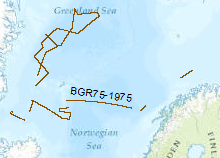
Reconnaissance surveys were carried out in 1975 within the framework of the BGR program "Geoscientific studies in the North Atlantic". The data format is Society of Exploration Geophysicists SEG Y. The areas covered were the continental margin of Spitsbergen, the Barents Sea and the Norwegion continental margin. On the vessel LONGVA (30th August, 1975 - 29th September, 1975) multichannel seismic measurements were carried out on 37 lines with a total length of 2,815 km.
-
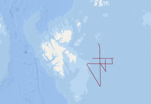
The research cruise PANORAMA-1 onboard the Italian vessel OGS Explora was carried out within 2 legs in the period August, 16th – September 17th 2013. The designated survey area was located in a sector of the European Arctic north of Svalbard covering an area north of 80°N between 15°E and 35°E. Main objectives were to acquire new geophysical data and extract near surface sediment samples in an underexplored area of the European Arctic with special focus on the transition zone from the North Barents shelf towards the oceanic Nansen basin. During leg 1 of the cruise a 20 days geophysical survey 1056 km of multi-channel seismic data was acquired supplemented by a 221 km long sonobuoy profile. Additionally, magnetic and sediment echosounding data was acquired along these profiles. During all operations within the survey area gravity and multibeam echosounding data was continuously acquired. After a 1 day stopover in Longyearbyen in order to exchange part of the scientific crew OGS Explora returned to the survey area to continue survey operations during leg 2. Within these 10 days period near surface sediments were extracted by means of a gravity corer at 12 locations and heat flow soundings were conducted at 7 locations. Gravity, sediment and multibeam echosounding data was continuously acquired along all transit lines within the survey area during leg 2. Total line length of magnetic data was 2658.7 km. Over all track lines with bathymetric and gravity data amount to 5665.8 km in total.
-
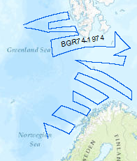
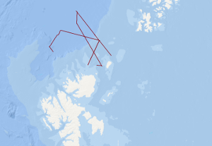
Reconnaissance surveys were carried out in 1974 within the framework of the BGR program "Geoscientific studies in the North Atlantic". The areas covered were the continental margin of Spitsbergen, the Barents Sea and the Norwegian continental margin. On the R/V LONGVA (10th August, 1974 - 10th September, 1974) multichannel seismic measurements were carried out on 40 lines with a total length of 8,091 km. The data format is Society of Exploration Geophysicists SEG Y.
-
During the period from 1974 to 2018 various cruises from BGR acquired seismic lines worldwide. The aim of these marine expeditions was a detailed survey of the geological structure.
-
During the period from 1974 to 2023 various cruises from BGR acquired seismic lines worldwide. The aim of these marine expeditions were a detailed survey of the geological structure of seabed.