 My GeoNetwork catalogue
Greenland
Provided by
Type of resources
Topics
Keywords
Contact for the resource
Update frequencies
-
The WSGL31 TTAAii Data Designators decode as: T1 (W): Warnings T1T2 (WS): SIGMET A1A2 (GL): Greenland (Remarks from Volume-C: NilReason)
-
The WVGL31 TTAAii Data Designators decode as: T1 (W): Warnings T1T2 (WV): Volcanic ash clouds (SIGMET) A1A2 (GL): Greenland (Remarks from Volume-C: NilReason)
-
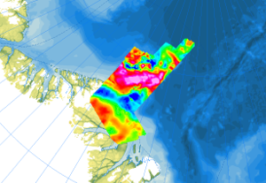
In 1998, as part of the expedition NOGRAM I (Northern Gravity, Radio Echo Sounding and Magnetics), a flight campaign was carried out over the Lincoln Sea north of Greenland with the Polar 2 aircraft (Dornier 228-100) in cooperation with the Alfred Wegener Institute Helmholtz Center for Polar and Marine Research. A second flight campaign NOGRAM II took place in 2011 with the Polar 5 (Basler BT-67) over the Wandel Sea north of Greenland. The aim of the research was the structure and architecture of the upper Earth’s crust underneath the ice-covered offshore areas of the Morris Jesup Plateau and coastal waters north of Greenland. The airborne magnetic surveys were carried out with a flight line spacing of 3 km, and control profiles were flown every 30 km. During the two expeditions, 33000 km of line data were collected (16000 km in 1998, and 17000 km in 2011).
-
The SAGL31 TTAAii Data Designators decode as: T1 (S): Surface data T1T2 (SA): Aviation routine reports A1A2 (GL): Greenland (Remarks from Volume-C: NilReason)
-
The SAGL32 TTAAii Data Designators decode as: T1 (S): Surface data T1T2 (SA): Aviation routine reports A1A2 (GL): Greenland (Remarks from Volume-C: NilReason)
-
The UAGL61 TTAAii Data Designators decode as: T1 (U): Upper air data T1T2 (UA): Aircraft reports A1A2 (GL): Greenland T1T2ii (UA61): Special aircraft reports, except for volcanic ash (Remarks from Volume-C: NilReason)
-
The UAGL71 TTAAii Data Designators decode as: T1 (U): Upper air data T1T2 (UA): Aircraft reports A1A2 (GL): Greenland T1T2ii (UA71): Special aircraft reports, related to volcanic ash (Remarks from Volume-C: NilReason)
-
The FTGL31 TTAAii Data Designators decode as: T1 (F): Forecast T1T2 (FT): Aerodrome (VT >= 12 hours) A1A2 (GL): Greenland (Remarks from Volume-C: NilReason)
-
The FTGL32 TTAAii Data Designators decode as: T1 (F): Forecast T1T2 (FT): Aerodrome (VT >= 12 hours) A1A2 (GL): Greenland (Remarks from Volume-C: NilReason)
-
The FCGL45 TTAAii Data Designators decode as: T1 (F): Forecast T1T2 (FC): Aerodrome (VT < 12 hours) A1A2 (GL): Greenland (Remarks from Volume-C: NilReason)