 My GeoNetwork catalogue
society
Provided by
Type of resources
Available actions
Topics
Keywords
Contact for the resource
Update frequencies
-
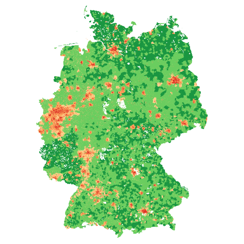
The degree of urbanization provides urbanization level information at 100x100 meter grids for Germany. It is based on population numbers, building density and the share of building types. It is provided as a continuous percentage value representing the probability of the degree of urbanization, as well as five discrete values representing classes of the degree of urbanization: definitely ‘urban’, probably ‘urban’, area of uncertainty, probably ‘rural’, definitely ‘rural’.
-
Stadtgebietsfläche der Stadt Göttingen nach unterschiedlichen Nutzungsarten seit dem Jahr 1860
-
-
Im Kreisgebiet Mettmann befindliche Förderschulen bzw. Förderzentren des Kreises Mettmann und der kreisangehörigen Städte mit den Förderschwerpunkten "Geistige Entwicklung", "Sprache", "Lernen" und "Emotionale und Soziale Entwicklung".
-

In Göttingen wurden am 09.06.2024 über zwei Bürgerbegehren zum Thema Radfahren in Göttingen und die damit verbundene Strategie entschieden. Wobei sich der Radentscheid 1 mit "Allgemeinen Strategien" beschäftigt. Die Wähler konnten dafür oder dagegen stimmen. Die Ergebnisse können für die gesamte Stadt oder schon kumuliert für die Wahlbezirke betrachtet werden, wobei es durch die Briefwahl hier zu Verschiebungen kommen kann. Die Datensätze enthalten folgende Informationen: datum : Datum des Wahltermins; wahl : Name der Wahl; ags : AGS der Behörde; gebiet-nr : Nummer des Wahlgebiets; gebiet-name : Name des Wahlgebiets; max-schnellmeldungen : Anzahl an insgesamt erwarteten Schnellmeldungen im Wahlgebiet; anz-schnellmeldungen : Anzahl an bisher eingegangenen Schnellmeldungen im Wahlgebiet; A1 : Wahlberechtigte ohne W; A2 : Wahlberechtigte mit W; A3 : Wahlberechtigte nicht im WVZ; A : Wahlberechtigte insgesamt; B : Stimmberechtigte insgesamt; B1 : Stimmberechtigte mit Wahlschein; C : Ungültige Stimmen; D : Gültige Stimmen; D1: Ja-Stimmen; D2: Nein-Stimmen
-

Die Ergebnisse der Landtagswahl vom 15.10.2017 für die Stadt Göttingen. Dabei können die Ergebnisse für die Stadt Göttingen als Gesamtergebnis sowie für die einzelnen Ortsteile, die Wahlbereiche und Wahlbezirke abgerufen werden. In der Ergebnisdarstellung nach Ortsteilen werden aufgrund der Struktur der Briefwahlbezirke nicht alle Briefwahlergebnisse einberechnet. Einige Briefwahlbezirke in der Stadt Göttingen liegen nur ortsteilübergreifend vor (bspw. EIN Briefwahlbezirk für Elliehausen, Esebeck, Groß Ellershausen, Hetjershausen und Knutbühren). Weiterhin sind einige Briefwahlbezirke von Ortsteilen gleichzeitig auch anderen Bezirken zugeorndet, die nicht zu Ortsteilen gehören. (Bspw. BW-Bezirk 155 Oststadt+Herberhausen). Diese o.g. Ergebnisse werden in den Ergebnissen nach Ortsteilen nicht berücksichtigt. Davon betroffen sind die Ortsteile Elliehausen, Esebeck, Groß Ellershausen, Hetjershausen, Knutbühren, Holtensen, Nikolausberg, Roringen, Herberhausen. In den Ergebnisansichten der Wahlkreise und Wahlbereiche werden die Briefwahlergebnisse natürlich komplett berücksichtigt Die Dateien enthalten folgende Felder: Landtagswahl (17 Göttingen-Stadt) datum : Datum des Wahltermins wahl : Name der Wahl ags : AGS der Behörde gebiet-nr : Nummer des Wahlgebiets gebiet-name : Name des Wahlgebiets max-schnellmeldungen : Anzahl an insgesamt erwarteten Schnellmeldungen im Wahlgebiet anz-schnellmeldungen : Anzahl an bisher eingegangenen Schnellmeldungen im Wahlgebiet A1 : Wahlberechtigte ohne Sperrvermerk 'W' A2 : Wahlberechtigte mit Sperrvermerk 'W' A3 : Wahlberechtigte nicht im Wählerverzeichnis A : Wahlberechtigte insgesamt B : Wähler B1 : Wähler mit Wahlschein C : Ungültige Erststimmen D : Gültige Erststimmen E : Ungültige Zweitstimmen F : Gültige Zweitstimmen D1 : Erststimmen für Partei 1 ... : ... D99 : Erststimmen für Partei 99 F1 : Zweitstimmen für Partei 1 ... : ... F99 : Zweitstimmen für Partei 99 Bei der aktuellen Landtagswahl (17 Göttingen-Stadt) treten folgende Parteien an: D1 / F1 : Christlich Demokratische Union Deutschlands in Niedersachsen D2 / F2 : Sozialdemokratische Partei Deutschlands D3 / F3 : BÜNDNIS 90/DIE GRÜNEN D4 / F4 : Freie Demokratische Partei D5 / F5 : DIE LINKE. Niedersachsen D6 / F6 : Alternative für Deutschland (AfD) Niedersachsen D9 / F9 : Bündnis Grundeinkommen - Die Grundeinkommenspartei D13 / F13 : Deutsche Mitte - Politik geht anders... D16 / F16 : FREIE WÄHLER Niedersachsen D17 / F17 : Liberal-Konservative Reformer Niedersachsen D18 / F18 : Ökologisch-Demokratische Partei, Landesverband Niedersachsen D19 / F19 : Partei für Arbeit, Rechtsstaat, Tierschutz, Elitenförderung und basisdemokratische Initiative D20 / F20 : PARTEI MENSCH UMWELT TIERSCHUTZ Landesverband Niedersachsen D21 / F21 : Piratenpartei Niedersachsen D22 / F22 : V-Partei³ - Partei für Veränderung, Vegetarier und Veganer D23 : Einzelbewerber Yusuf Demirbag
-
-
-
Im Kreisgebiet Mettmann befindliche Schulen, unterteilt nach den Kategorien Grundschulen, Gesamtschulen, Hauptschulen, Realschulen, Sekundarschulen, Gymnasien, Berufskollege und sonstige Schulen.
-
