 My GeoNetwork catalogue
Nordatlantik
Provided by
Type of resources
Available actions
Topics
Keywords
Contact for the resource
Service types
-
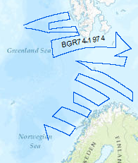
Reconnaissance surveys were carried out in 1974 within the framework of the BGR program "Geoscientific studies in the North Atlantic". The areas covered were the continental margin of Spitsbergen, the Barents Sea and the Norwegian continental margin. On the R/V LONGVA (10th August, 1974 - 10th September, 1974) multichannel seismic measurements were carried out on 40 lines with a total length of 8,091 km. The data format is Society of Exploration Geophysicists SEG Y.
-
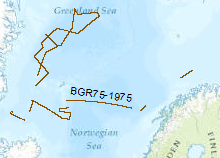
Reconnaissance surveys were carried out in 1975 within the framework of the BGR program "Geoscientific studies in the North Atlantic". The data format is Society of Exploration Geophysicists SEG Y. The areas covered were the continental margin of Spitsbergen, the Barents Sea and the Norwegion continental margin. On the vessel LONGVA (30th August, 1975 - 29th September, 1975) multichannel seismic measurements were carried out on 37 lines with a total length of 2,815 km.
-
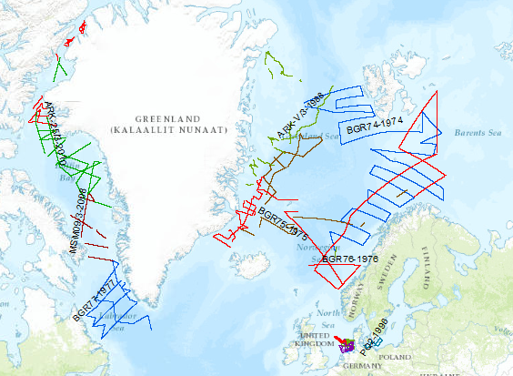
During the period from 1974 to 2018 various cruises from BGR acquired seismic lines worldwide. The aim of these marine expeditions was a detailed survey of the geological structure.
-
During the period from 1974 to 2023 various cruises from BGR acquired seismic lines worldwide. The aim of these marine expeditions were a detailed survey of the geological structure of seabed.