 My GeoNetwork catalogue
Federal Institute for Geosciences and Natural Resources
Provided by
Type of resources
Available actions
Topics
Keywords
Contact for the resource
Service types
-
In the period from February 13th to March 2nd 1980 4,037 km of magnetic, gravity and bathymetric lines and 1,195 km of digital reflection seismic lines were recovered on the 2nd leg of METEOR cruise no. 53. Heat flow measurements have been performed on 13 stations; on two stations sonobuoy refraction measurements and dredging have been carried out. From a preliminary interpretation of the seismic monitor records the Mazagan Plateau is part of the Moroccan Meseta. Seawards of this stable swell lies the 75 km wide, downfaulted rift graben characterized by salt diapirs. A submarine body, 150 square kilometres large, lying at the foot of the Mazagan Escarpment in water depths of 3000 m - 3800 m beneath sea level, from which western flank few granitic fragments were retrieved, is interpreted as a subsided and tilted block of the Mazagan Plateau. The north-trending magnetic anomalies, discovered during METEOR cruise no. 46 within the Essaouira continental margin segment have also been recognized within the Tafelney Plateau segment, situated between latitudes 30°45'N and 31°30'N off Morocco. Two neo-volcanic zones were found west of the Conception Bank and west of the Betancuria Massif/Fuerteventura Is. The Mesozoic and Tertiary depositional sequences are highly deformed by small piercement structures interpreted as dykes within these zones.
-
During cruise BGR79 from 29th June to 3rd September 1979 the Federal Institute for Geosciences and Natural Resources (BGR) carried out marine seismic reflection surveys in the three separate areas of the North Atlantic Ocean (Norwegian Sea, Scotian Basin, and U.S. East Coast Area) with S.V. EXPLORA. Simultaneously gravity, magnetic and reflection seismic data were recorded on parts of the lines. In addition, 66 sono-buoys were deployed for seismic refraction data recording on various seismic lines in all three areas. A detailed survey in the Norwegian Sea took place in the time from 29th June to 15th July, 1979 between the southern Vøring Plateau, the Jan Mayen Fracture Zone, the Møre Basin and the Faeroe-Shetland escarpment during leg 1 of cruise BGR79. The data showed that the Møre Basin contains a small sub-basin in the western part, the West-Shetland Basin. Further seaward, an outer high as well as a zone of intrusions were imaged.
-
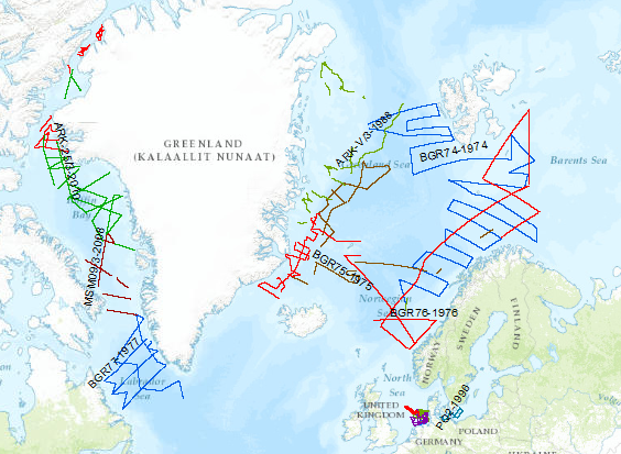
During the period from 1974 to 2018 various cruises from BGR acquired seismic lines worldwide. The aim of these marine expeditions was a detailed survey of the geological structure.
-
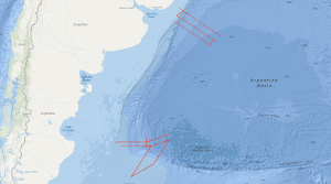
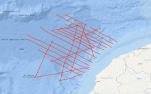
From 19th November to 19th December 2004 BGR conducted a marine geophysical cruise between 34°S and 36°S off Uruguay and between 46°S and 50°S off Argentine. The main research objective was to contribute to a better understanding of the initial breakup and the early opening of the South Atlantic. In continuation of our former work on the South Atlantic continental margins off Argentina, Brazil, Uruguay, Namibia and South Africa marine geophysical research (multi-channel seismics, refraction-/wide-angle reflection seismics, magnetics and gravity) was performed in close cooperation with the Argentine and Uruguayan authorities Comisión Nacional del Límite Exterior de la Plataforma Continental (COPLA) of Argentina and Servicio de Oceanograficia, Hidrograficia y Meteorologia de la Armada (SOHMA) of Uruguay. Multi-channel seismic lines with a total length of 3,754 km and additional 3540 km with the other geophysical methods were acquired . Along two lines refraction-/wide-angle reflection seismic work was carried out. The preliminary analyses of the new seismic data show different images of the crustal structures between Uruguay and southern Argentine with regard to the distribution and volume of offshore volcanic rocks (seaward dipping reflector sequences, SDRS) along the South American Atlantic margin. On the northern profiles between 34°S and 36°S one single well developed wedge of SDRS is present. Although the landward termination (‘feather edge’) on most of the lines is masked by multiples the average total width of the wedge across the margin seems to be 90 – 100 km and is very constant for this margin segment. This is strong contrast to the results from former cruises (BGR87, SO85 and BGR98) which covered the area between 38°S and 45°S. There, the SDRS showed distinct multiple wedges which in some places extend over 120 km across the continental slope. The investigation of the sedimentary section yielded that in the area off Uruguay widespread bottom simulating reflectors (BSR) are present. This indications for stable gas hydrates cover a total area of 7000 km2. One major aim of the cruise was to cover the transition between a volcanic passive margin and a non-volcanic passive resp. sheared margin. This was accomplished in the southern part of the investigated area. Two EW-trending profiles across the Argentine shelf into the Argentine Basin still show indications for SDRS but these structures are only 25 – 30 km wide. The profiles which extend from the NE to the SW crossing the Agulhas-Falkland Fracture Zone (AFFZ) onto the Falkland Plateau show the typical trend of a sheared margin. At the northern rim of the Falkland Plateau a set of small pre-rift half grabens were found indicating pre-rift extensional tectonic phases. The magnetic data in the area off Uruguay show lineations which are preliminary interpreted as chrons M0 to M3. This might indicate that the first (oldest) oceanic crust was created at a time around the magnetic polarity reversal between the normal interval M4 and the reversed interval M3 (126-127 Ma). Together with existing data from previous cruises this indicates that the breakup of the South Atlantic started further South because there magnetic chrons back to M9 (130 Ma) were identified. In the southernmost part of the margin at 47°S only the magnetic lineations M0 to M4 were identified in the oceanic domain Nevertheless, it is likely that between M4 and the assumed position of the continent ocean boundary/transition (COB/COT) older oceanic crust exists that for some reasons does not show correlatable lineations. The the free-air gravity map is dominated by the main topographic and structural features in the survey area. Rifted continental margins are characterized by prominent free-air gravity anomalies elongated parallel to the ocean-continent transition. The continental slope is considerably steeper in the North off Uruguay than in the South and thus the gravity high is much more pronounced in the North than in the South. The simple Bouguer anomaly map also shows the difference between the more gentle and wider continental slope in the South and the steeper slope in the North. The lowest Bouguer gravity values are found in the area of the basins on the continental shelf. Especially the Salado Basin in the prolongation of the Rio de la Plata and the Colorado Basin at about 40°S are indicated by Bouguer gravity anomaly highs. The interpretation by forward density modelling shows, however, the presence of SDRS units in the North of relative high density in the area of the continental slope. Whereas the modelling shows no indications for such volcanic bodies in the South. Although the MCS data indicate a small SDRS wedge but this body may be too small to cause an anomaly.From 17th April to 6th June 2003 BGR conducted a marine geophysical cruise between 30°S and 38°S off the Atlantic coast of South Africa. The main research objective was to contribute to a better understanding of the initial breakup and the early opening of the South Atlantic. In continuation of our former work on the South Atlantic continental margins off Argentina, Brazil, Uruguay and Namibia marine geophysical research (multi-channel seismics, wide-angle refraction seismics, magnetics and gravity) was performed in cooperation with the Petroleum Agency South Africa (PASA). Multi-channel lines with a total lenght of 3,260 km, and additional 1,365km, with the other geophysical methods were acquired. Combined onshore/offshore refraction seismic work in cooperation with GeoForschungsZentrum Potsdam (Germany) and the Council for Geoscience (South Africa) was also part of the program.
-
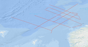
On the first leg of SONNE cruise SO-36 in the period from 11th February to 12th March 1985, geophysical investigations have been carried out on the Lord Howe Rise off eastern Australia by the Federal Institute for Geosciences and Natural Resources (BGR) in co-operation with the Bureau of Mineral Resources, Geology and Geophysics, Canberra. A total of 3,660 km of digital seismic reflection profiles, 6,740 km of gravity, magnetics, multibeam echosounder and sub-bottom profiler profiles, as well as 8 sonobuoy refraction profiles were recorded during this survey. A geomagnetic monitoring station of the BGR was operated during a part of the cruise on Lord Howe Island under the supervision of the BMR. These measurements provided a detailed picture of the structures of the survey area of the Lord Howe Rise. The samples proved that the Lord Howe Rise and the Dampier Ridge west of it consist of continental crust. Indications for structures rich in hydrocarbons were not observed. The 2nd and 3rd leg of SONNE cruise SO-36 were designed to investigate the structure, geological development and hydrocarbon potential of two frontier areas, the western and southwestern continental margin of Tasmania and the South Tasman Rise. On the 2nd leg (12.03.-12.04.1985) multichannel seismic reflection measurements were carried out in parallel with magnetic, gravimetric, sea-beam and 3.5 kHz subbottom profiler measurements on 19 lines with a total length of 3,820 km. In addition, 2,140 km were surveyed with magnetics, gravity meter, sea-beam and 3.5 kHz subbottom profiler in transit from and to Sydney, respectively. On the 3rd leg, which started in Sydney on 12th April 1985 and ended in Suva/Fiji one month later, 63 stations were sampled by dredging and coring with the aim (a) to provide lithology and biostratigraphic information about the seismic sequences mapped during leg 2, and (b) to obtain geochemical evidence of hydrocarbon generation from the character of gases absorbed onto the surficial sediment. Samples came from 33 stations off Western Tasmania, from 23 stations on the South Tasman Rise, and from 7 stations in the region of the Lord Howe Rise and the Dampier Ridge. In transit to the sampling sites, 11 single channel seismic lines with a total length of 470 km were surveyed, and in addition, 4,230 km were surveyed with magnetics, gravity meter, sea-beam, and subbottom profiler. Seven regional seismic unconformities were recognized and sampled, and the structural style of both areas was established. Thermogenic hydrocarbons in substantial concentration were found in the surface sediments at the western Tasmanian slope.
-
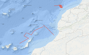
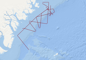
The area of the 1st leg of METEOR cruise no. 67 lies off the Moroccan coast between longitudes 32.5°N and 35°N and latitude 12°W. Within this continental margin segment multichannel reflection seismic measurements were carried out in parallel with magnetic and gravimetric measurements on 22 lines with a total length of 4,378 km during the period from January 20th to February 13th 1984, with the research objectives: i) to collect new geophysical data for a better understanding of magmatic-volcanic and tectonic processes during the initial drifting phase, and ii) to search for suitable positions for deep drilling sites of the "Ocean Drilling Programme" in the transition zone between continental and oceanic crust. A distinct and sharp reflection seismic boundary running from about 31°30'N/11°W in the south to 34°30'N/10°25'W in the north separates flat-lying Mesozoic sediments overlying slightly structured basement of the Jurassic "Magnetic Quiet Zone" from the complex Moroccan piercement zone in the east. A prominent magnetic anomaly, called S1, is nearly coincident with the sharp reflection seismic boundary, and is thought to represent most probably the initial drifting zone. The Moroccan piercement zone is interpreted to represent the eastern part of a pre-Jurassic rift-basin which conjugated western part lies off Nova Scotia/Canada. Subsidence associated with small-scale rotational block-faulting was time-transgressive in the Moroccan piercement zone, e.g. it started in Triassic time in the central part of the rift-basin and affected successively its landward parts apparently due to successively cooling of the stretched and thinned crust. Weak magnetic anomalies trending approximately NE-SW were recorded within the Jurassic "Magnetic Quiet Zone" lying west of magnetic anomaly S1. These anomalies can be correlated over distances of up to 300 km. They are interpreted to represent either variations of the geomagnetic field intensity or field reversals during a time of weak geomagnetic field.
-
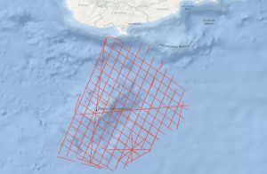
The initial study area of the cruise MSM14/2 GeoNORM (Geophysik im noerdlichen Roten Meer) was the northern Red Sea. However, because of not given research permissions from Egypt and Saudi Arabia, the study area had to be changed to the alternative study area Eratosthenes Seamount (ESM), south of Cyprus. The ESM is supposed to represent a continental fragment of the former African-Arabian Plate that is entering the subduction zone south of Cyprus i.e. the subduction turns into collision in the area of the ESM. This changed the entire tectonic setting in the Eastern Mediterranean. Therefore, the tectonic evolution of the area is rather complex with phases of extension, subduction, compression, salt tectonics and gravitational processes and not comprehensively understood. Because of the isolation of the ESM as a continental fragment this region is an ideal spot to investigate the transition from regular subduction to continental collision and its associated tectonic processes i.e. faults were activated or reactivated, transform motion has to be compensated, the overriding plate has been elevated. This impacts the ongoing geological and tectonic processes in this region but also influences the social and economic life in the Eastern Mediterranean as earthquakes and submarine landslides are possible geohazards and the entering of the ESM to the subduction trench alters the thermal history of the adjacent sedimentary basins significantly what should have an influence on the maturity processes within the source rock sediments and new faults open new migration paths for hydrocarbon fluids or gases.
-
The main purpose of the cruise SO75 from 14th October to 12th November 1991 was to test the new instrumentation of the SONNE and the ship itself for the needs of marine geophysics. The second purpose was the investigation of the crustal structure of the Atlantic Ocean from the Madeira-Torre Rise to the continental slope of Portugal which is conjugate to the margin off Newfoundland being investigated by a previous BGR cruise (Hinz et al., 1989). Methods used were multichannel reflection seismics, gravimetry, magnetics, swath echosounding and sediment echography. The test of the ship and its result is discussed in a separate technical report (Roeser et al., 1991). On two lines crossing the Madeira-Torre Rise we have observed seaward dipping reflector sequences. Their position is conjugate to similar features observed off Newfoundland. Magnetic models for one line show a strong magnetization of the whole reflector sequence. Thus, in analogy to the drilled dipping reflector sequence on the Vøring Plateau, it is likely that it mainly consists of lava flows which were extruded subaerially or in shallow water. In contrast to the dipping reflector sequences found earlier, the newly detected sequences are far away from continental crust. Presumably, at the time of their formation the Midatlantic Ridge was subaerial. Geometrical constraints indicate a compressional regime for the eastern part of the Azores-Gibraltar Fracture Zone. Most prominent expression of this is the Gorringe Bank. Our seismic line across it indicates an overthrusting of oceanic crust, however, it does not show any evidence for a Benioff zone. Therefore, only a small amount of oceanic crust can be subducted until now. We have observed compressional features also in the Tagus Abyssal Plain. Our lines north of the Azores-Gibraltar Fracture Zone did not confirm the weak indications for a continuation of the magnetic anomaly M0 across the fracture zone. The present platetectonic models for this area require therefore a modification. For the definition of the ocean-continent transition in the Iberia Abyssal Plain and for the investigation of the nature of the crust near the transition zone 6 ODP drillsites have been proposed. In response to a request by R.B. Whitmarsh from the Institute of Oceanographic Sciences at Wormley, Godalming, we have carried out the required ODP Site Survey.
-
The MSM67 SEGMENT research cruise was carried out between August 31st and October 4th 2017 aboard the research vessel MARIA S. MERIAN. Survey MSM67 SEGMENT it is intended to study the architecture of the rifted continental margin off East Greenland around the Jan Mayen fracture zone. Key issues to be addressed are margin segmentation and the location of the continent-ocean transition (COT). Both subjects are highly debated. Symmetric segmentation of conjugate margins has significant implications on our general understanding of continental rifting processes, and a margin-parallel COT off East Greenland would indicate an N-S opening in the Norwegian/Greenland Sea. The latter challenging most publications on the early evolution of the North Atlantic. A major open question is also the timing, duration and distribution of magmatism that resulted in the formation of the North Atlantic large igneous province. Previous suggestions of very short (~3 Myr) periods of intense magmatism have been challenged and a much longer duration and/or a post-breakup origin are under discussion. Here, we want to establish the amount of post-breakup magmatism as evident in high-velocity lower crust and test the dependence of magmatism with distance from the proposed hot-spot under Iceland and the influence of major fracture zones on volcanism.
-
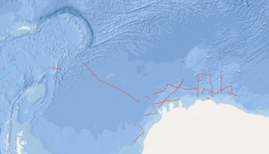
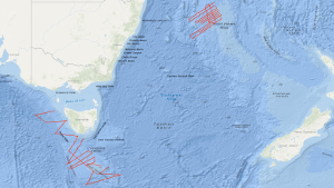
The preceding results of the Deep Sea Drilling Project/International Program of Ocean Drilling (DSDP/IPOD) have shown that inspection of borehole cores in the Southern Ocean and around Antarctica are necessary for reconstruction of the development of the Atlantic Ocean and for the understanding of the sedimentary deposition which is strongly affected by the palaeo-oceanographic processes. As the geological development of the Weddell Sea plays a key role for the reconstruction of the south-american and african part of the former supercontinent Gondwana, the Federal Institute for Geosciences and Natural Resources (BGR) has decided to conduct a synoptic geophysical survey in the eastern Weddell Sea and in front of the eastern Antarctic continental margin. This survey has been designed as a prearrangement for a larger "presite" program for preparation of future DSDP/IPOD sites. The main focus of the geophysical survey during the first leg of cruise BGR78 from 5th of January to 13th of February 1978 with M.S. EXPLORA has been put on the continental margin of the south-eastern Weddell Sea and eastern Antarctica between 20°E and 30°W and south of 67°S. Especially the lines BGR78-03 to BGR78-23 of seismic reflection measurements have been carried out in this region which were affected by heavy ice conditions at this time. Additionally, on 43 stations sonobuoy refraction measurements have been conducted.