 www.geodatenkatalog.de (S3L)
Keyword
Jordan
4 record(s)
Provided by
Type of resources
Available actions
Topics
Keywords
Contact for the resource
Update frequencies
-
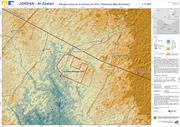
The map shows the elevation of the surroundings of the Al Zaatari refugee camp in Jordan. The elevation information is derived from ASTER GDEM 2 data (vertical accuracy +/- 6m). Furthermore basic reference information, digitized on the basis of WorldView-2 satellite data acquired on January 03, 2013, at 08:52:52 UTC and LANDSAT-7 data acquired on December 16, 2012 at 08:07:11 UTC, is depicted. Not all settlements are captured. The results have not been validated in the field. ASTER GDEM 2 data as well as a hillshade derived from this data is used as backdrop. Please note, that information on elevation derived from ASTER data does not apply for the refugee camp area. ASTER data was acquired before 2011 and the elevation might have changed due to construction works. The products elaborated for this Rapid Mapping Activity are realised to the best of our ability, within a very short time frame, optimising the material available. All geographic information has limitations due to the scale, resolution, date and interpretation of the original source materials. No liability concerning the content or the use thereof is assumed by the producer. The ZKI crisis maps are constantly updated. Please make sure to visit http://www.zki.dlr.de for the latest version of this product.
-

The map shows the Al Zaatari refugee camp in Jordan. It is situated approx. 12 km from the Syrian border and in close proximity to the city of Al Mafraq (10 km). The camp was set up on July 28, 2012, to shelter refugees fleeing the conflict in Syria. The map shows general characteristics of the camp infrastructure, including camp extent, location of shelters, containers and facility buildings, road infrastructure and the runway area. For a more detailed view parts of the camp area are also shown in the zoom boxes. The vector data have been digitized on the basis of WorldView-2 satellite data (0.5 m spatial resolution) acquired on January 03, 2013. The results have not been validated in the field. WorldView-2 satellite data acquired on January 03, 2013, is used as backdrop. The products elaborated for this Rapid Mapping Activity are realised to the best of our ability, within a very short time frame, optimising the material available. All geographic information has limitations due to the scale, resolution, date and interpretation of the original source materials. No liability concerning the content or the use thereof is assumed by the producer. The ZKI crisis maps are constantly updated.
-
DWD’s fully automatic MOSMIX product optimizes and interprets the forecast calculations of the NWP models ICON (DWD) and IFS (ECMWF), combines these and calculates statistically optimized weather forecasts in terms of point forecasts (PFCs). Thus, statistically corrected, updated forecasts for the next ten days are calculated for about 5400 locations around the world. Most forecasting locations are spread over Germany and Europe. MOSMIX forecasts (PFCs) include nearly all common meteorological parameters measured by weather stations. For further information please refer to: [in German: https://www.dwd.de/DE/leistungen/met_verfahren_mosmix/met_verfahren_mosmix.html ] [in English: https://www.dwd.de/EN/ourservices/met_application_mosmix/met_application_mosmix.html ]