 www.geodatenkatalog.de (S2L)
Keyword
urn:eop:DLR:EOWEB:NOAA.AVHRR.LST_N
1 record(s)
Provided by
Type of resources
Topics
Keywords
Contact for the resource
Update frequencies
-
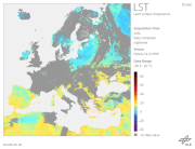
The "Land Surface Temperature derived from NOAA-AVHRR data (LST_AVHRR)" is a fixed grid map (in stereographic projection) with a spatial resolution of 1.1 km. The total size covering Europe is 4100 samples by 4300 lines. Within 24 hours of acquiring data from the satellite, day-time and night-time LSTs are calculated. In general, the products utilise data from all six of the passes that the satellite makes over Europe in each 24 hour period. For the daily day-time LST maps, the compositing criterion for the three day-time passes is maximum NDVI value and for daily night-time LST maps, the criterion is the maximum night-time LST value of the three night-time passes. Weekly and monthly day-time or night-time LST composite products are also produced by averaging daily day-time or daily night-time LST values, respectively. The range of LST values is scaled between –39.5°C and +87°C with a radiometric resolution of 0.5°C. A value of –40°C is used for water. Clouds are masked out as bad values. For additional information, please see: https://wdc.dlr.de/sensors/avhrr/