 My GeoNetwork catalogue
Environment
Provided by
Type of resources
Available actions
Topics
Keywords
Contact for the resource
Update frequencies
Service types
-
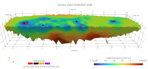
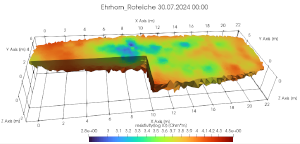
The series contains data from the three project locations. The data set contains the measured raw data from ERT measurements, processed data and inversion results.
-
The data set contains the measured raw data from ERT measurements, processed data and inversion results.
-
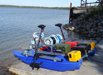
Lake Runstedt, around 30 km west of Leipzig, is a post-mining lake created by the flooding of the former Großkayna open-cast mine. After the end of the lignite mining, the pit was partially filled with industrial waste and fly ash for several decades. With high concentrations of ammonium in the sediment, oxygen consumption due to nitrification of ammonium released into the lake is a major challenge to the lake’s water quality. To ensure the oxygen supply in the hypolimnion (i.e. the bottom lake layer that is not affected by wind mixing) in summer, three aerators are operated in the lake by the Lausitzer und Mitteldeutsche Bergbau-Verwaltungsgesellschaft (LMBV). In 2023, the Freiberg University of Mining and Technology was commissioned by the BGR to carry out three measurement campaigns (end of July/beginning of August, mid-September, mid-October) on the lake using an autonomous surface vehicle (here: a catamaran-shaped robotic device) to assess the spatial effects of the aeration on lake water quality. The data set provided contains the collected three-dimensional data of water temperature, oxygen content, pH, electrical conductivity, turbidity and chlorophyll. In addition, laboratory analyses of water samples obtained with a Ruttner sampler are included. The data reflect the conditions before and after operation of the aerators. Detailed explanations can be found in the publication “Spatial heterogeneity of dissolved oxygen and sediment fluxes revealed by autonomous robotic lakewater profiling” (2025) by Röder et al. in the journal Limnology and Oceanography (http://doi.org/10.1002/lno.70174).
-
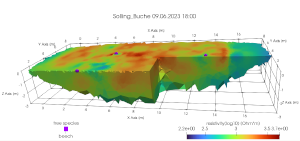
The data set contains the measured raw data from ERT measurements, processed data and inversion results.
-
The data set contains the measured raw data from ERT measurements, processed data and inversion results.
-
-
-
-
-