 My GeoNetwork catalogue
opendata
Provided by
Type of resources
Available actions
Topics
Keywords
Contact for the resource
Update frequencies
Service types
-
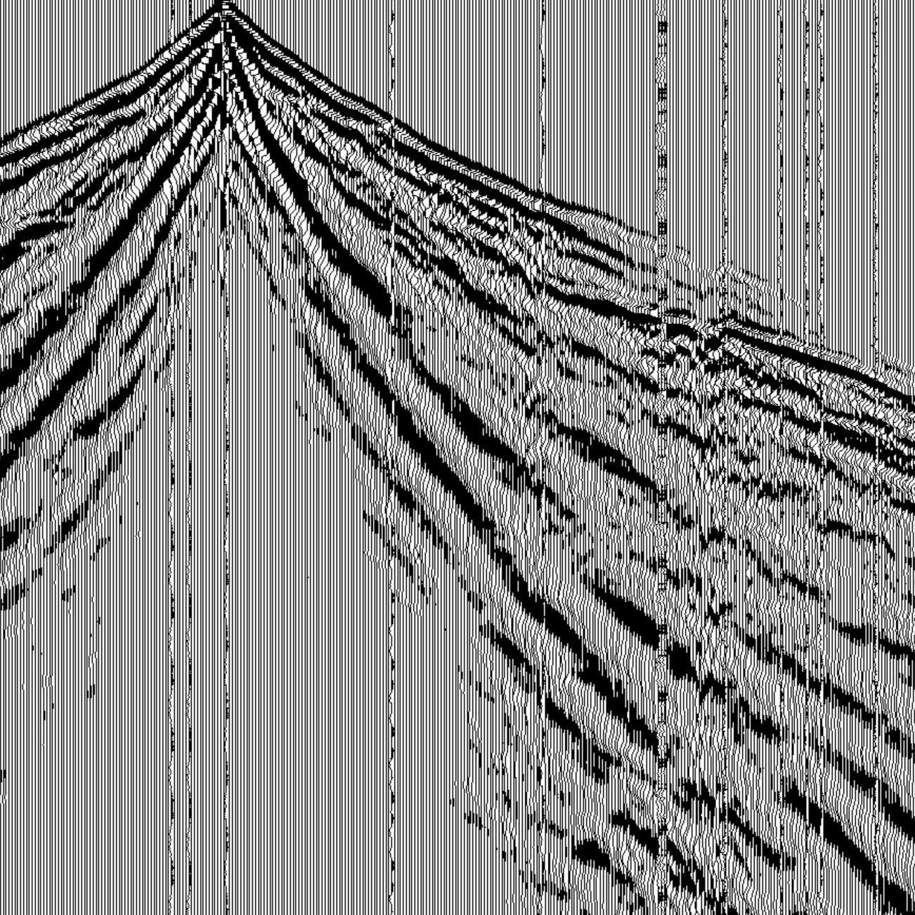
Supplementary information to the manuscript “Seismoacoustic analysis of a Falcon 9 rocket stage re-entry over central Europe on 19 February 2025” by Hupe et al. (2026). Results of the Progressive Multi-Channel Correlation (PMCC) processing for far-field infrasound stations, displayed in Figure 7 of the manuscript (IS26 in Germany, NRSI in Norway, HFSI in Sweden). The netcdf files contain the following detection parameters of single arrivals: Time, duration, back-azimuth, apparent velocity, frequency, family identifier. Data format: One .nc file for each station.
-
Die Stadtgrenze entspricht dem Verwaltungsgebiet der Stadt Göttingen. Das Gebiet wird mittels eines Polygons dargestellt.
-

Navigation Lock Filling - Modeled Geometry and Physical Model Measurement Data This data set provides the geometry files and physical model measurement data for the filling process of a large navigation lock with a ship in the lock chamber from a water saving basin. The measured data contains water levels, pressure differences, forces on the ship and the opening height of the valves. The lock consists of a lock chamber with a pressure chamber underneath. Both chambers are hydraulically connected with vertical cylindrical filling nozzles inside the floor between both chambers. The three lateral saving basins are connected to the pressure chamber via two lateral culverts each of smoothly varying rectangular shape. Each saving basin has two of these connecting culverts. A vertical lifting valve in each culvert allows the controlled filling operation from the saving basins into the pressure chamber. In the experiment, the lock chamber is filled from the lowest saving basin. The physical model was constructed at a scale of 1:25. The provided data (geometry and model test results) is scaled to prototype scale by Froude's similitude. The data was used in the following publication: Thorenz, C., Schulze, L. (2021): Numerical Investigations of Ship Forces During Lockage. Journal of Coastal and Hydraulic Strucures. Please cite the paper when using the data.
-
Friedhöfe im Stadtgebiet der Stadt Göttingen.
-
Busliniennetz der Göttinger Verkehrsbetriebe. Dies beinhaltet das Liniennetz im Stadtgebiet der Stadt Göttingen sowie Bovenden und Rosdorf. Das Liniennetz der Überlandbusse sind nicht enthalten.
-
Within the framework of DOVE, the project Chatseis combines two seismic methods to increase resolution and reliability of the seismic data; i.e. reflection imaging and full-waveform inversion. To acquire the optimal data for the tasks in the project Chatseis, the German Federal Institute for Geosciences and Resources conducted two seismic surveys together with the Leibniz Institute for Applied Geophysics and the Bayerisches Landesamt für Umwelt. At the DOVE-site 5068_3 (Schäftlarn), the project team registered seismic P-wave data with explosive and vibration sources and different geophones as well as S-wave data with a small-scale vibratory source and a landstreamer system on three profiles (in total ca 3.8 km, 100 GB for P-wave and ca 2.6 km, 16 GB for S-wave).
-
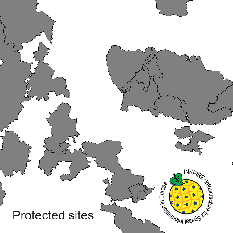
Protected Sites of Germany, derived from the german digital landscape model at scale 1:250000. Mapped via EuroRegionalMap to satisfy INSPIRE and European Location Framework conformance. The dataset is available as Open Data.
-
Two strong eruptions of Stromboli Volcano (38.789°N 15.213°E, 920 m) occurred on July 3rd and August 28th 2019. This data set provides the infrasound records in terms of raw pressure data in Pascal of both eruptions available at BGR’s infrasound array I26DE in Germany as well as infrasound arrays OHP and CEA in France. The publication “Using dense seismo-acoustic network to provide timely warning of the 2019 paroxysmal Stromboli eruptions” (Le Pichon et al., 2021, Scientific Reports) provides further details on this data set and its scientific application. Data format: The data are provided as ASCII files (separate file for each infrasound sensor and hour of measurement, plus a README file).
-
Dieser Dienst liefert die Blattschnitteinteilung des (historischen) Topographischen Atlas 1:50000 für das Großherzogtum Baden und das Königreich Württemberg mit den Attributen Blattnummer, Blattnamen sowie Ausgabejahr.
-

Modelled sea surface height above mean sea level of the operational circulation model of the Federal Maritime and Hydrographic Agency of Germany (BSH), in the German Bight and the western Baltic Sea (horizontal resolution ca. 900 m). The model (HBM, HIROMB-BOOS-Model) is run four times each day in a configuration with a fine grid in the German Bight and western Baltic Sea (900 m resolution, this dataset) and a coarser grid which covers the North and Baltic Sea (5 km resolution, separate dataset). The model is forced by the weather forecast of the German Weather Service (DWD). More detailed information about the model configuration can be found in Brüning et al. (2021); https://doi.org/10.23784/HN118-01. For more information, please visit: https://gdi.bsh.de/en/data/Modelled-Sea-Surface-Height-Above-Mean-Sea-Level-of-the-operational-circulation-model-of-BSH-in-the-German-Bight-and-the-western-Baltic-Sea-horizontal-resolution-ca-900-m-2018_FactSheet_HBMnoku_english.pdf https://gdi.bsh.de/en/data/Modelled-Sea-Surface-Height-Above-Mean-Sea-Level-of-the-operational-circulation-model-of-BSH-in-the-German-Bight-and-the-western-Baltic-Sea-horizontal-resolution-ca-900-m-2018_FactSheet_HBMnoku_deutsch.pdf