 My GeoNetwork catalogue
unknown
Provided by
Type of resources
Available actions
Topics
Keywords
Update frequencies
Service types
-
-
-
-
-
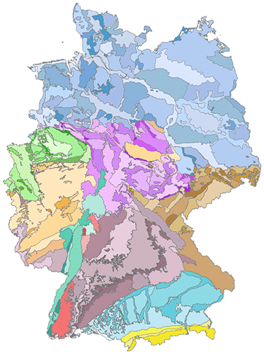
The hydrogeological spatial structure provides a delimitation of areas with very similar hydrogeological characteristics. These areas, with increasing detail, include large hydrogeological regions, hydrogeological regions and hydrogeological subregions. Each higher level is completely made up of one or more units of the next lower level. In order to compile a digital map of large hydrogeological regions, hydrogeological regions and subregions of Germany, existing regional maps and drafts of the State Geological Surveys have been harmonised and brought together. All in all, the territory of Germany has been subdivided in 10 large hydrogeological regions, in 36 hydrogeological regions and 247 hydrogeological subregions.
-

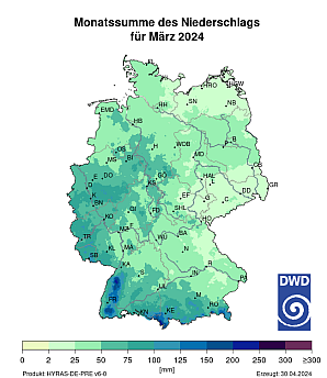
These grids are a product derived from HYRAS-DE-PRE. HYRAS-DE-PRE is a precipitation product for Germany in a 1 km x 1 km grid for the period 1931 to the previous day and is based on daily measured values of precipitation height. The data set can be used, for example, for the analysis of past climate, for bias adjustment of regionalized climate projection data and as input data for hydrological modeling.
-

HYRAS-DE-PRE is a precipitation product for Germany in a 1 km x 1 km grid for the period 1931 to the previous day and is based on daily measured values of precipitation height. The data set can be used, for example, for the analysis of past climate, for bias adjustment of regionalized climate projection data and as input data for hydrological modeling.
-
These grids are a product derived from HYRAS-DE-PR. HYRAS-DE-PR is a precipitation product for Germany in a 1 km x 1 km grid for the period 1931 to the previous day and is based on daily measured values of precipitation height. The data set can be used, for example, for the analysis of past climate, for bias adjustment of regionalized climate projection data and as input data for hydrological modeling.
-

Archivebene der zurückgebauten Gebäude seit 2001 (Datum der Ersterfassung)