Keyword
hydrogeology
7 record(s)
Provided by
Type of resources
Available actions
Keywords
Update frequencies
Service types
-
-
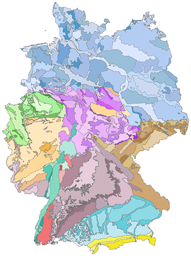
The hydrogeological spatial structure provides a delimitation of areas with very similar hydrogeological characteristics. These areas, with increasing detail, include large hydrogeological regions, hydrogeological regions and hydrogeological subregions. Each higher level is completely made up of one or more units of the next lower level. In order to compile a digital map of large hydrogeological regions, hydrogeological regions and subregions of Germany, existing regional maps and drafts of the State Geological Surveys have been harmonised and brought together. All in all, the territory of Germany has been subdivided in 10 large hydrogeological regions, in 36 hydrogeological regions and 247 hydrogeological subregions.
-

The hydrogeological spatial structure provides a delimitation of areas with very similar hydrogeological characteristics. These areas, with increasing detail, include large hydrogeological regions, hydrogeological regions and hydrogeological subregions. Each higher level is completely made up of one or more units of the next lower level. In order to compile a digital map of large hydrogeological regions, hydrogeological regions and subregions of Germany, existing regional maps and drafts of the State Geological Surveys have been harmonised and brought together. All in all, the territory of Germany has been subdivided in 10 large hydrogeological regions, in 36 hydrogeological regions and 247 hydrogeological subregions.
-
Der interoperable INSPIRE-WFS ist ein Downloaddienst, der Daten im INSPIRE-Zielschema Geologie (abgeleitet aus dem originären Datensatz: Hydrogeologische Raumgliederung Brandenburg) bereitstellt. Er gibt einen Überblick über die hydrogeologischen Raumgliederungen Brandenburgs. Die Gliederungseinheiten tragen den angewandten Charakter von Nutzungsräumen. Sie werden anhand von Wassereinzugsgebieten und Charakteristiken dazugehöriger Grundwasserdynamik beschrieben. Für das Territorium einer hydrogeologischen Einheit werden vergleichbare Grundwasserverhältnisse vorausgesetzt. Gemäß der INSPIRE-Datenspezifikation für Geology liegen die Inhalte INSPIRE-konform vor. Der WFS beinhaltet die folgenden FeatureTypes: - Geologische Einheit (ge:GeologicUnit): Ein Gesteinskörper mit spezifischen Eigenschaften. Mit Angaben zur Art der geologischen Einheit (ge:GeologicUnit.geologicUnitTypeValue). - Kartiertes Merkmal (ge:MappedFeature): Eine räumliche Darstellung eines GeologicFeature. - Geologische Sammlung (ge:GeologicCollection): Eine Gruppe geologischer oder geophysikalischer Objekte. --- The compliant INSPIRE-WFS is a download service that delivers data in the INSPIRE target schema Geology (derived from the original data set: Hydrogeological spatial classification Brandenburg). It provides an overview of the hydrogeological classification of Brandenburg. The classification units have the applied character of utilisation areas. They are described on the basis of water catchment areas and characteristics of associated groundwater dynamics. Comparable groundwater conditions are assumed for the territory of a hydrogeological unit. The content is compliant to the INSPIRE Data Specification on Geology. The WFS includes the following FeatureTypes: - Geologic unit (ge:GeologicUnits): A volume of rock with distinct characteristics. With information on the type of geological unit (ge:GeologicUnit.GeologicUnitType). - Mapped feature (ge:MappedFeature): A spatial representation of a GeologicFeature. - Geologic collection (ge:GeologicCollection): A collection of geological or geophysical objects.
-
Der interoperable INSPIRE-Datensatz beinhaltet Daten vom LBGR über die Hydrogeologische Raumgliederung Brandenburg, transformiert in das INSPIRE-Zielschema Geologie. Der Datensatz wird über je einen interoperablen Darstellungs- und Downloaddienst bereitgestellt. --- The compliant INSPIRE data set contains data about the hydrogeological spatial classification in the State of Brandenburg from the LBGR, transformed into the INSPIRE target schema Geology. The data set is provided via compliant view and download services.
-
Der interoperable INSPIRE-WMS ist ein Darstellungsdienst, der Daten im INSPIRE-Zielschema Geologie (abgeleitet aus dem originären Datensatz: Hydrogeologische Raumgliederung Brandenburg) bereitstellt. Er gibt einen Überblick über die hydrogeologischen Raumgliederungen Brandenburgs. Die Gliederungseinheiten tragen den angewandten Charakter von Nutzungsräumen. Sie werden anhand von Wassereinzugsgebieten und Charakteristiken dazugehöriger Grundwasserdynamik beschrieben. Für das Territorium einer hydrogeologischen Einheit werden vergleichbare Grundwasserverhältnisse vorausgesetzt. Gemäß der INSPIRE-Datenspezifikation für Geology liegen die Inhalte INSPIRE-konform vor. Der WMS beinhaltet den folgenden Layer: - GE.geologicUnit: Geologische Einheit, die unbekannt, nicht definiert, irrelevant oder deren Art nicht im Vokabular aufgeführt ist. --- The compliant INSPIRE-WMS is a view service that delivers data in the INSPIRE target schema Geology (derived from the original data set: Hydrogeological spatial classification Brandenburg). It provides an overview of the hydrogeological classification of Brandenburg. The classification units have the applied character of utilisation areas. They are described on the basis of water catchment areas and characteristics of associated groundwater dynamics. Comparable groundwater conditions are assumed for the territory of a hydrogeological unit. The content is compliant to the INSPIRE Data Specification on Geology. The WMS includes the following layer: - GE.geologicUnit: Type of geologic unit that is unknown, unspecified, irrelevant, or some type not included in the vocabulary.
-
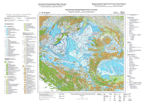
The International Hydrogeological Map of Europe, scale 1:1,500,000 is a series of general hydrogeological maps comprising 25 map sheets with explanatory notes, covering the whole European continent and parts of the Near East. The national contributions to this map series were compiled by hydrogeologists and experts in related sciences of the countries concerned under the auspices of the International Association of Hydrogeologists (IAH) and its Commission on Hydrogeological Maps (COHYM). The project is supported by the Commission for the Geological Map of the World (CGMW).The scientific editorial work is supported financially by the Government of the Federal Republic of Germany through the Bundesanstalt für Geowissenschaften und Rohstoffe (BGR) and by the United Nations Educational, Scientific and Cultural Organization (UNESCO). These organizations are responsible for the cartography, printing and publication of the map sheets and explanatory notes.The series of hydrogeological maps seeks to represent the hydrogeological setting of Europe as a whole without regard to political boundaries. Together with the information presented in the accompanying explanatory notes, the map can be used for scientific purposes, for large-scale regional planning and as a basis for detailed hydrogeological mapping.
 www.geodatenkatalog.de (S1L)