 My GeoNetwork catalogue
FEDEO
Provided by
Type of resources
Available actions
Topics
Keywords
Contact for the resource
Update frequencies
-
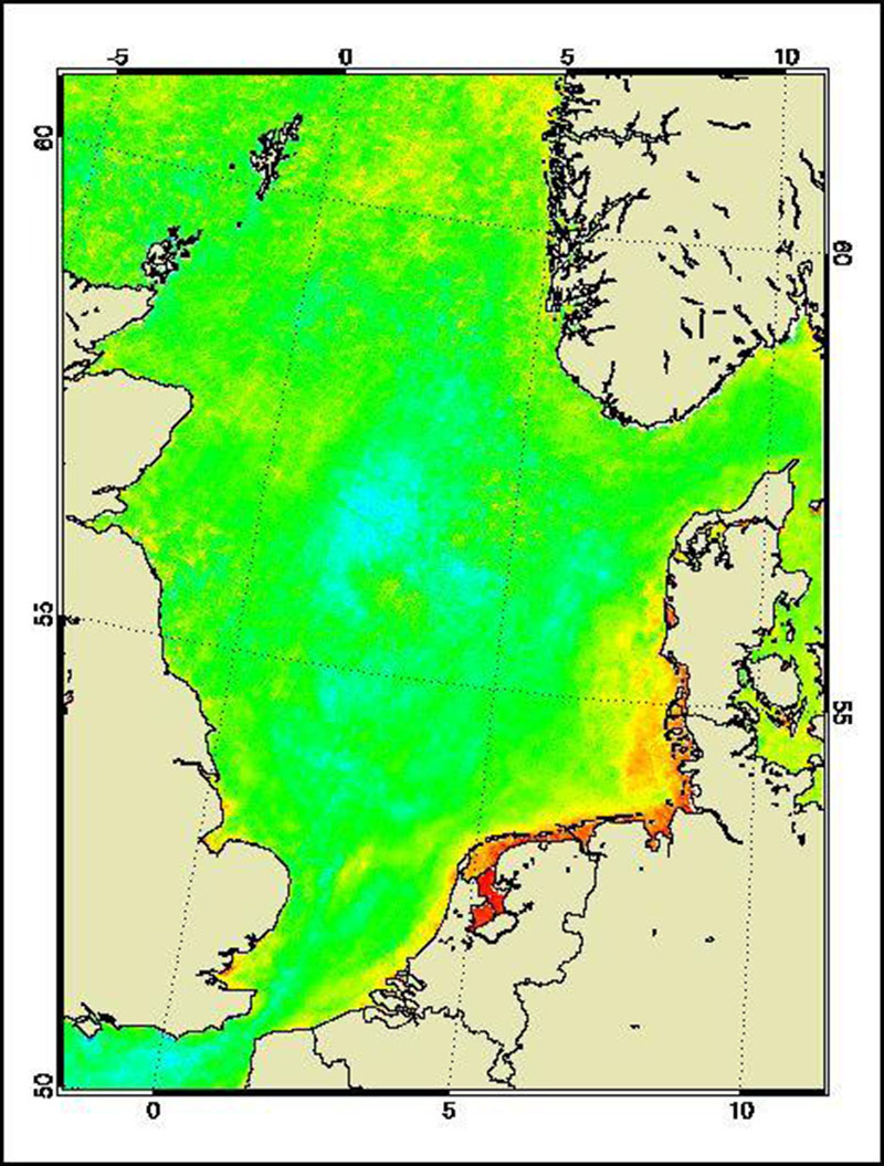
The Medium Resolution Imaging Spectrometer (MERIS) on Board ESA’s ENVISAT provides spectral high resolution image data in the visible-near infrared spectral region (412-900 nm) at a spatial resolution of 300 m. For more details on ENVISAT and MERIS see http://envisat.esa.int/ This product developed in the frame of the MAPP project (MERIS Application and Regional Products Projects) represents the chlorophyll concentration of the North Sea derived from MERIS data. The product is a cooperative effort of DLR-DFD and the Institute for Coastal Research at the GKSS Research Centre Geesthacht. DFD pre-processed up to the value added level whenever MERIS data for the North Sea region was received and positively checked for a water area large enough for a suitable interpretation. For more details the reader is referred to http://wdc.dlr.de/sensors/meris/ and http://wdc.dlr.de/sensors/meris/documents/Mapp_ATBD_final_i3r0dez2001.pdf This product provides monthly maps.
-

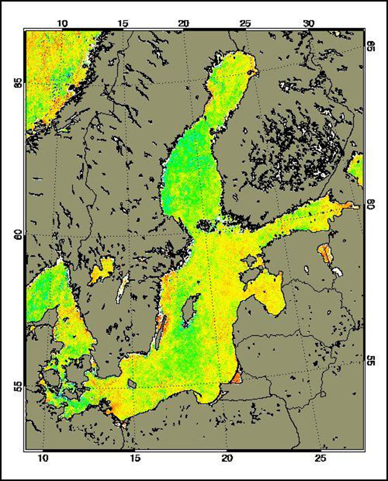
The Medium Resolution Imaging Spectrometer (MERIS) on Board ESA’s ENVISAT provides spectral high resolution image data in the visible-near infrared spectral region (412-900 nm) at a spatial resolution of 300 m. For more details on ENVISAT and MERIS see http://envisat.esa.int/ Spectral high resolution measurements allow to assess different water constituents in optically complex case-2 waters (IOCCG, 2000). The main groups of constituents are Chlorophyll, corresponding to living phytoplankton, suspended minerals or sediments and dissolved organic matter. They are characterised by their specific inherent optical properties, in particular scattering and absorption spectra. The Baltic Sea Water Constituents product was developed in a co-operative effort of DLR (Remote Sensing Technology Institute IMF, German Remote Sensing Data Centre DFD), Brockmann Consult (BC) and Baltic Sea Research Institute (IOW) in the frame of the MAPP project (MERIS Application and Regional Products Projects). The data are processed on a regular (daily) basis using ESA standard Level-1 and -2 data as input and producing regional specific value added Level-3 products. The regular data reception is realised at DFD ground station in Neustrelitz. For more details the reader is referred to http://wdc.dlr.de/sensors/meris/ and http://wdc.dlr.de/sensors/meris/documents/Mapp_ATBD_final_i3r0dez2001.pdf This product provides monthly maps.
-
The Medium Resolution Imaging Spectrometer (MERIS) on Board ESA’s ENVISAT provides spectral high resolution image data in the visible-near infrared spectral region (412-900 nm) at a spatial resolution of 300 m. For more details on ENVISAT and MERIS see http://envisat.esa.int/ Spectral high resolution measurements allow to assess different water constituents in optically complex case-2 waters (IOCCG, 2000). The main groups of constituents are Chlorophyll, corresponding to living phytoplankton, suspended minerals or sediments and dissolved organic matter. They are characterised by their specific inherent optical properties, in particular scattering and absorption spectra. The Baltic Sea Water Constituents product was developed in a co-operative effort of DLR (Remote Sensing Technology Institute IMF, German Remote Sensing Data Centre DFD), Brockmann Consult (BC) and Baltic Sea Research Institute (IOW) in the frame of the MAPP project (MERIS Application and Regional Products Projects). The data are processed on a regular (daily) basis using ESA standard Level-1 and -2 data as input and producing regional specific value added Level-3 products. The regular data reception is realised at DFD ground station in Neustrelitz. For more details the reader is referred to http://wdc.dlr.de/sensors/meris/ and http://wdc.dlr.de/sensors/meris/documents/Mapp_ATBD_final_i3r0dez2001.pdf This product provides seasonal maps.
-
Indian Remote Sensing satellites (IRS) are a series of Earth Observation satellites, built, launched and maintained by Indian Space Research Organisation. The IRS series provides many remote sensing services to India and international ground stations. With 5 m resolution and products covering areas up to 70 km x 70 km IRS PAN data provide a cost effective solution for mapping tasks up to 1:25'000 scale.
-

The Medium Resolution Imaging Spectrometer (MERIS) on Board ESA’s ENVISAT provides spectral high resolution image data in the visible-near infrared spectral region (412-900 nm) at a spatial resolution of 300 m. For more details on ENVISAT and MERIS see http://envisat.esa.int/ Spectral high resolution measurements allow to assess different water constituents in optically complex case-2 waters (IOCCG, 2000). The main groups of constituents are Chlorophyll, corresponding to living phytoplankton, suspended minerals or sediments and dissolved organic matter. They are characterised by their specific inherent optical properties, in particular scattering and absorption spectra. The Baltic Sea Water Constituents product was developed in a co-operative effort of DLR (Remote Sensing Technology Institute IMF, German Remote Sensing Data Centre DFD), Brockmann Consult (BC) and Baltic Sea Research Institute (IOW) in the frame of the MAPP project (MERIS Application and Regional Products Projects). The data are processed on a regular (daily) basis using ESA standard Level-1 and -2 data as input and producing regional specific value added Level-3 products. The regular data reception is realised at DFD ground station in Neustrelitz. For more details the reader is referred to http://wdc.dlr.de/sensors/meris/ and http://wdc.dlr.de/sensors/meris/documents/Mapp_ATBD_final_i3r0dez2001.pdf This product provides 10-day maps.
-

Indian Remote Sensing satellites (IRS) are a series of Earth Observation satellites, built, launched and maintained by Indian Space Research Organisation. The IRS series provides many remote sensing services to India and international ground stations. \\n\\nIRS LISS-III data are well suited for agricultural and forestry monitoring tasks. Because of their simultaneous acquisition with IRS PAN data and the availability of a synthetic blue band, LISS-III data are ideal for colouring IRS PAN products.
-
Indian Remote Sensing satellites (IRS) are a series of Earth Observation satellites, built, launched and maintained by Indian Space Research Organisation. The IRS series provides many remote sensing services to India and international ground stations.
-
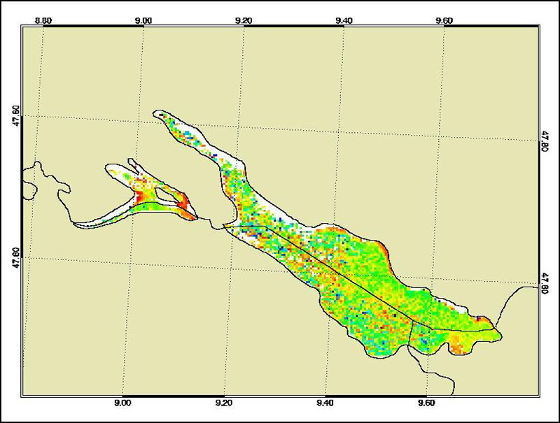
The Medium Resolution Imaging Spectrometer (MERIS) on Board ESA’s ENVISAT provides spectral high resolution image data in the visible-near infrared spectral region (412-900 nm) at a spatial resolution of 300 m. For more details on ENVISAT and MERIS see http://envisat.esa.int/ This product developed in the frame of the MAPP project (MERIS Application and Regional Products Projects) represents the chlorophyll concentration of Lake Constance derived from MERIS data. The product is a cooperative effort of DLR-DFD and the Institute for Coastal Research at the GKSS Research Centre Geesthacht. DFD pre-processed up to the value added level whenever MERIS data for the North Sea region was received and positively checked for a water area large enough for a suitable interpretation. For more details the reader is referred to http://wdc.dlr.de/sensors/meris/ and http://wdc.dlr.de/sensors/meris/documents/Mapp_ATBD_final_i3r0dez2001.pdf This product provides monthly maps.
-

The Medium Resolution Imaging Spectrometer (MERIS) on Board ESA’s ENVISAT provides spectral high resolution image data in the visible-near infrared spectral region (412-900 nm) at a spatial resolution of 300 m. For more details on ENVISAT and MERIS see http://envisat.esa.int/ Spectral high resolution measurements allow to assess different water constituents in optically complex case-2 waters (IOCCG, 2000). The main groups of constituents are Chlorophyll, corresponding to living phytoplankton, suspended minerals or sediments and dissolved organic matter. They are characterised by their specific inherent optical properties, in particular scattering and absorption spectra. The Baltic Sea Water Constituents product was developed in a co-operative effort of DLR (Remote Sensing Technology Institute IMF, German Remote Sensing Data Centre DFD), Brockmann Consult (BC) and Baltic Sea Research Institute (IOW) in the frame of the MAPP project (MERIS Application and Regional Products Projects). The data are processed on a regular (daily) basis using ESA standard Level-1 and -2 data as input and producing regional specific value added Level-3 products. The regular data reception is realised at DFD ground station in Neustrelitz. For more details the reader is referred to http://wdc.dlr.de/sensors/meris/ and http://wdc.dlr.de/sensors/meris/documents/Mapp_ATBD_final_i3r0dez2001.pdf This product provides daily maps.
-
Indian Remote Sensing satellites (IRS) are a series of Earth Observation satellites, built, launched and maintained by Indian Space Research Organisation. The IRS series provides many remote sensing services to India and international ground stations. With 5 m resolution and products covering areas up to 70 km x 70 km IRS PAN data provide a cost effective solution for mapping tasks up to 1:25'000 scale.