 My GeoNetwork catalogue
Nord-Ostsee-Kanal
Provided by
Type of resources
Available actions
Topics
Keywords
Contact for the resource
Service types
-

This dataset contains in-situ measurements of ship-generated wave heights and currents collected during 14 campaigns from 1998 to 2022 in German coastal waterways. It includes 81,092 filtered datapoints (from an initial 97,877) across 46 measurement stations in 28 cross-sections, with 23 unique locations, some of which were repeated after a certain time. Each wave event is linked to the ship and nautical parameters responsible for its generation. A more detailed metadata description for each campaign is attached to the dataset. Citation for this data set: Seemann, A.; Melling, G. (2024): Ship Wave Measurements in German Coastal Waterways from 1998 to 2022 [Data set], DOI: https://doi.org/10.48437/42c292-ebac3d Data Descriptor Paper: Seemann, A., Melling, G. Measurement of ship-generated waves in German coastal waterways from 1998–2022. Sci Data 12, 54 (2025). https://doi.org/10.1038/s41597-024-04299-5
-
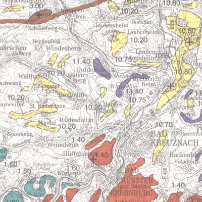
In order to exploit mineral raw materials close to the Earth's surface, experts are working on trans-regional and national planning documents. To do this, they need maps which clearly depict the raw materials close to the surface in Germany. KOR200 displays Germany's national raw material potential in a comparable way, thus forming a basis for future exploration and investigations as well as making a contribution towards the assurance of the supply of raw materials. The map follows the sheet line system of the topographical survey map 1:200.000 (TÜK 200) and consists of 55 sheets, each with an explanatory booklet. There is a review of the current situation, a description, a depiction and documentation of the occurrence and deposits of mineral raw materials which are usually extracted in mines either on or close to the Earth's surface. Such deposits include, in particular, industrial minerals, rocks and soils, peat, lignite, oil shale and brines. Besides the delimited deposits and areas of raw materials coloured according to the raw material in question, the maps also depict "mining areas" (=operations) or "focal points of several mining areas", each marked with a symbol. The map entries are - just as with the topographical basis - recorded in digitalised form in a databank, from which they can be retrieved via a computer using various search criteria. The entries in the map are supplemented by between 40 to 80 pages of textual explanations, which are currently available only in the printed edition of the map. The text is divided into: - introduction - description of the deposits and occurrence of useful rocks - supply and demand assessment of the deposits and occurrence of raw materials close to the Earth's surface in the area covered by the sheet - possible ways of using the useful rocks present in the sheet area - list of publications - appendix (with, amongst other things, a general legend and survey of sheets)
-

Beförderte Güter (Binnenschifffahrt): Deutschland, Jahre,Gefahrgut, Wasserstraßen, Güterverzeichnis (Abteilungen)
-
Beförderte Güter (Binnenschifffahrt): Deutschland, Jahre,Gefahrgut, Wasserstraßen, Güterverzeichnis (Abteilungen)