 My GeoNetwork catalogue
Belastung
Provided by
Type of resources
Available actions
Topics
Keywords
Contact for the resource
Update frequencies
Service types
-

This dataset contains in-situ measurements of ship-generated wave heights and currents collected during 14 campaigns from 1998 to 2022 in German coastal waterways. It includes 81,092 filtered datapoints (from an initial 97,877) across 46 measurement stations in 28 cross-sections, with 23 unique locations, some of which were repeated after a certain time. Each wave event is linked to the ship and nautical parameters responsible for its generation. A more detailed metadata description for each campaign is attached to the dataset. Citation for this data set: Seemann, A.; Melling, G. (2024): Ship Wave Measurements in German Coastal Waterways from 1998 to 2022 [Data set], DOI: https://doi.org/10.48437/42c292-ebac3d Data Descriptor Paper: Seemann, A., Melling, G. Measurement of ship-generated waves in German coastal waterways from 1998–2022. Sci Data 12, 54 (2025). https://doi.org/10.1038/s41597-024-04299-5
-
Web Feature Service (WFS) zum Thema Soll-Belastungsklassen des Straßenoberbaus für das Hamburger Stadtstraßennetz. Zur genaueren Beschreibung der Daten und Datenverantwortung nutzen Sie bitte den Verweis zur Datensatzbeschreibung.
-
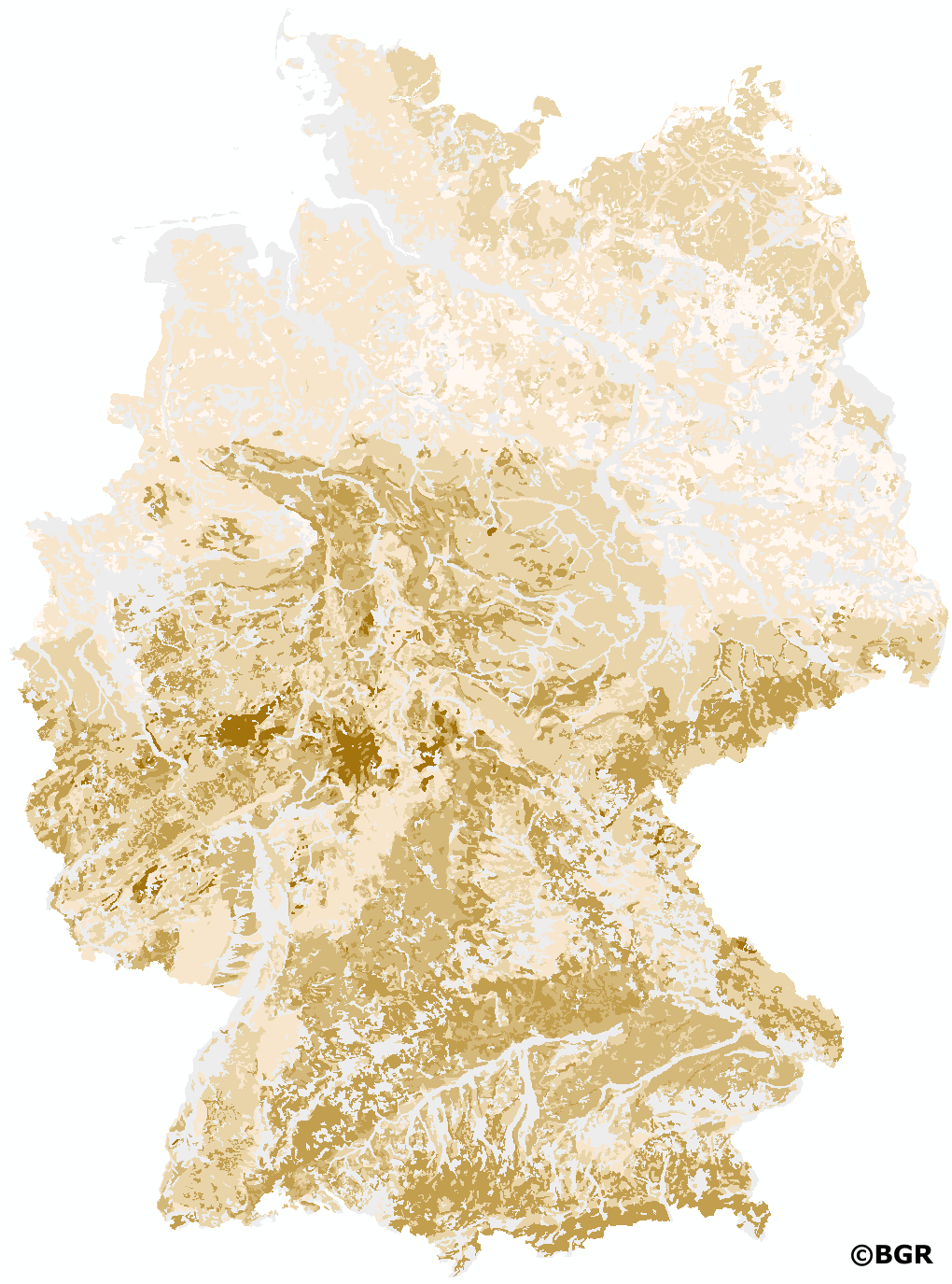
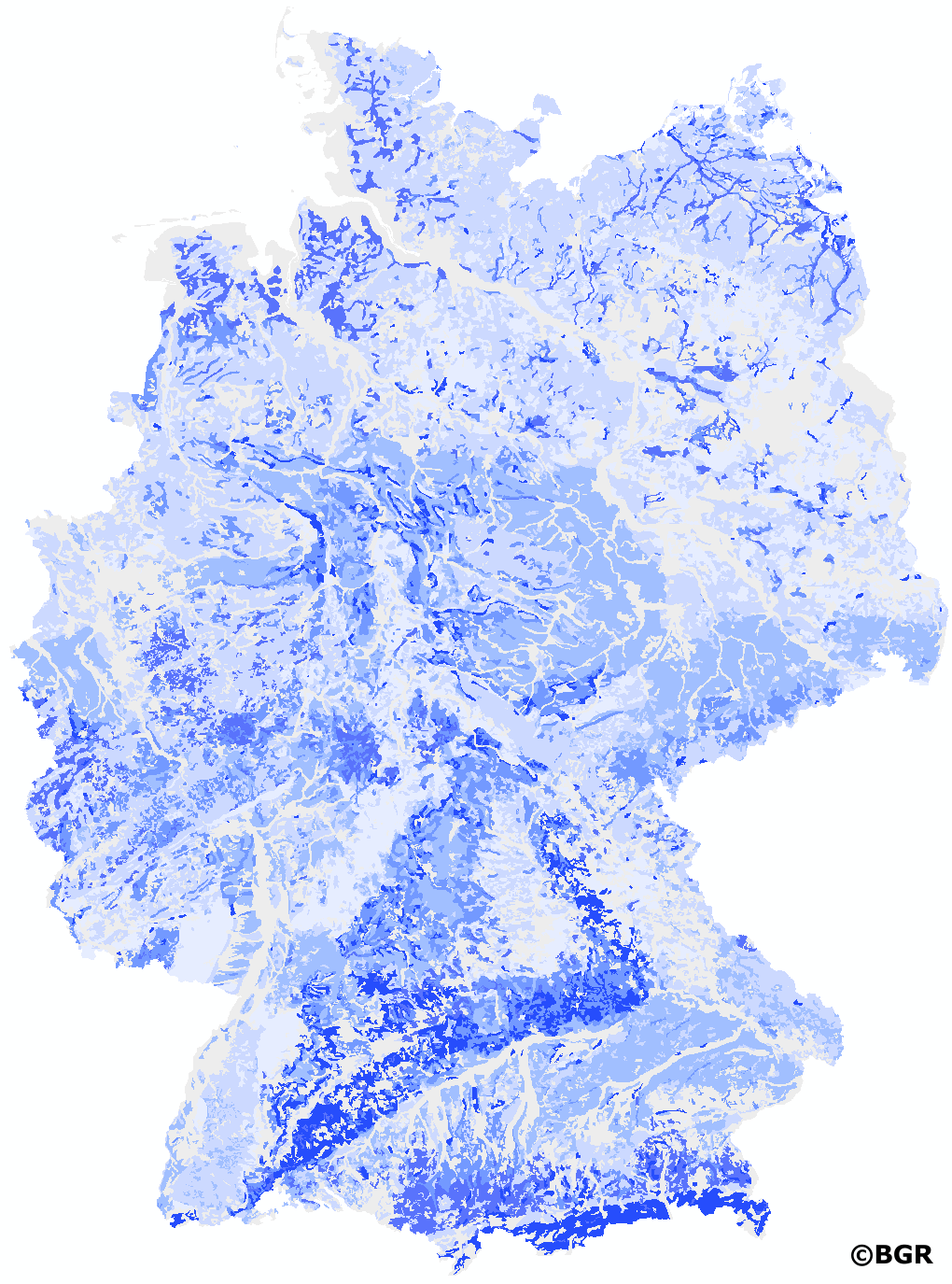
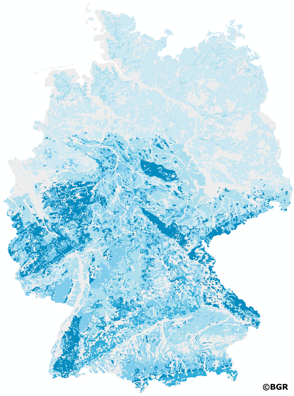
New, nationwide background values for 16 heavy metals and trace elements were published by the LABO in 2017. They are based on profile descriptions and measurements of aqua regia extracts, which were combined and homogenized by the BGR. Measurements with high quantification limits were excluded from further evaluation according to certain criteria in order to avoid their influence on the derivation of background values. To prevent the background values from being disproportionately influenced by regions with high sample densities, spatial thinning was partially performed. The values of several horizons of a site were combined to one value by depth-weighted averages. For evaluation, the available measured values were assigned to different groups of soil parent materials. In addition, a distinction was made whether the samples were taken in the topsoil, in the subsoil or in the underground. In the case of topsoil, the different land use (arable land, grassland, forest) was also taken into account for the evaluation. Unconsolidated rocks were evaluated separately for northern and southern Germany due to their different composition. By dividing the data into sub-collectives, reliable case numbers were not achieved in all cases. Consequently, only background values with case numbers ?20 are presented. The exact derivation procedure can be found in the report of the LABO-Bund/Länder-Arbeitsgemeinschaft Bodenschutz (2017): 'Hintergrundwerte für anorganische und organische Stoffe in Böden', 4th revised and supplemented edition.
-
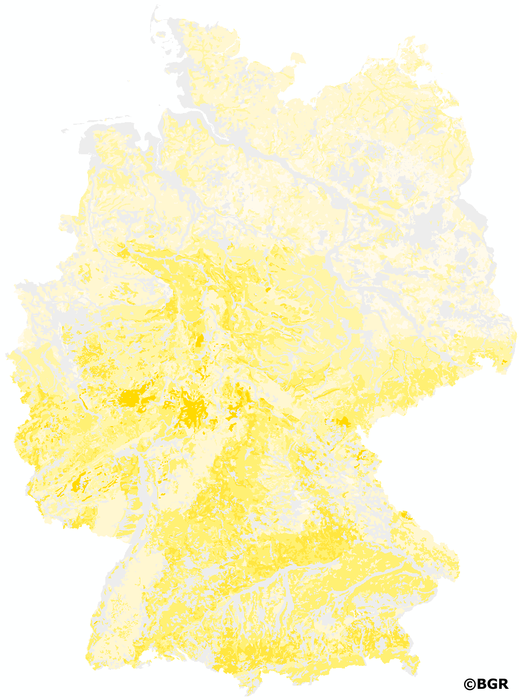
Web Map Service (WMS) zum Thema Soll-Belastungsklassen des Straßenoberbaus für das Hamburger Stadtstraßennetz. Zur genaueren Beschreibung der Daten und Datenverantwortung nutzen Sie bitte den Verweis zur Datensatzbeschreibung.
-

Als Verzeichnisflächen werden Boden- oder Grundwasserverunreinigungen erfasst, die nicht so erheblich sind, dass die Fläche als Altlast anzusprechen ist, bei denen es aber eine Belastung gibt.
-
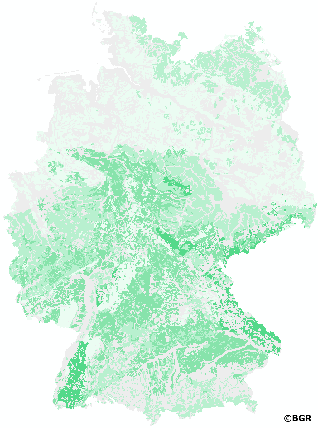
New, nationwide background values for 16 heavy metals and trace elements were published by the LABO in 2017. They are based on profile descriptions and measurements of aqua regia extracts, which were combined and homogenized by the BGR. Measurements with high quantification limits were excluded from further evaluation according to certain criteria in order to avoid their influence on the derivation of background values. To prevent the background values from being disproportionately influenced by regions with high sample densities, spatial thinning was partially performed. The values of several horizons of a site were combined to one value by depth-weighted averages. For evaluation, the available measured values were assigned to different groups of soil parent materials. In addition, a distinction was made whether the samples were taken in the topsoil, in the subsoil or in the underground. In the case of topsoil, the different land use (arable land, grassland, forest) was also taken into account for the evaluation. Unconsolidated rocks were evaluated separately for northern and southern Germany due to their different composition. By dividing the data into sub-collectives, reliable case numbers were not achieved in all cases. Consequently, only background values with case numbers ?20 are presented. The exact derivation procedure can be found in the report of the LABO-Bund/Länder-Arbeitsgemeinschaft Bodenschutz (2017): 'Hintergrundwerte für anorganische und organische Stoffe in Böden', 4th revised and supplemented edition.
-
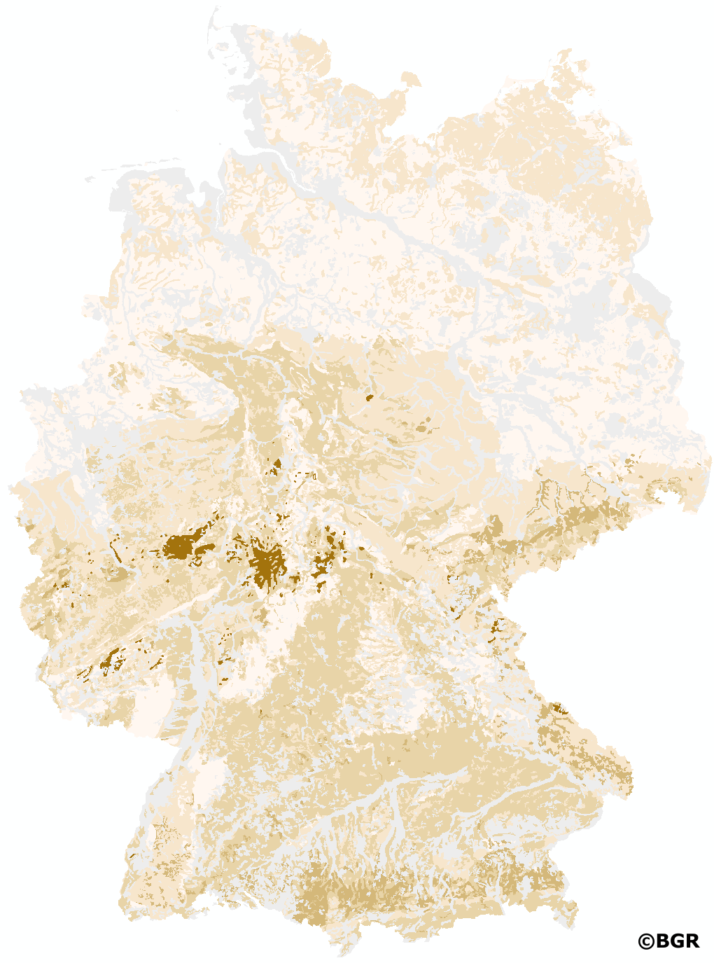
New, nationwide background values for 16 heavy metals and trace elements were published by the LABO in 2017. They are based on profile descriptions and measurements of aqua regia extracts, which were combined and homogenized by the BGR. Measurements with high quantification limits were excluded from further evaluation according to certain criteria in order to avoid their influence on the derivation of background values. To prevent the background values from being disproportionately influenced by regions with high sample densities, spatial thinning was partially performed. The values of several horizons of a site were combined to one value by depth-weighted averages. For evaluation, the available measured values were assigned to different groups of soil parent materials. In addition, a distinction was made whether the samples were taken in the topsoil, in the subsoil or in the underground. In the case of topsoil, the different land use (arable land, grassland, forest) was also taken into account for the evaluation. Unconsolidated rocks were evaluated separately for northern and southern Germany due to their different composition. By dividing the data into sub-collectives, reliable case numbers were not achieved in all cases. Consequently, only background values with case numbers ?20 are presented. The exact derivation procedure can be found in the report of the LABO-Bund/Länder-Arbeitsgemeinschaft Bodenschutz (2017): 'Hintergrundwerte für anorganische und organische Stoffe in Böden', 4th revised and supplemented edition.