 www.geodatenkatalog.de (S3L)
Keyword
Ausgangsgestein
4 record(s)
Provided by
Type of resources
Available actions
Topics
Keywords
Contact for the resource
Update frequencies
Service types
-
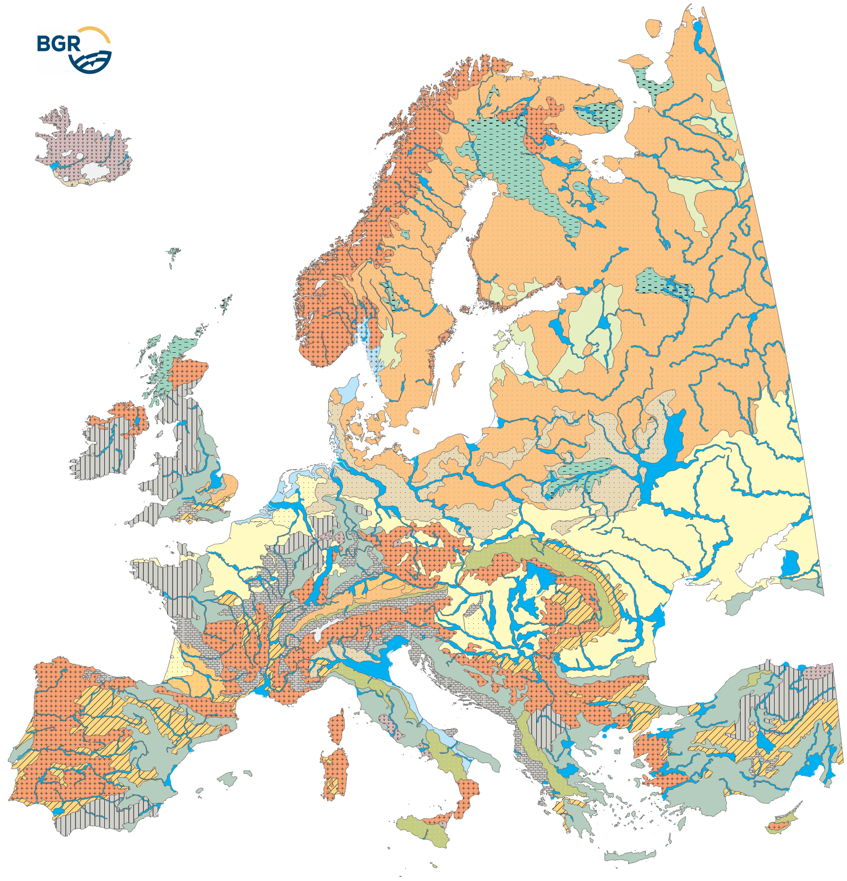
For the legend-building of the soil regions map (EUSR5000), areas with similar climate (EUCA15000) are further subdivided into areas with similar parent material, thus with a similar geologic paleogeographic development. Because the geological conditions (nature of parent material) are key factors for soil formation, it must be characterized at the level of the soil regions as well. In order to represent parent material at the Europe-wide continental level, data from small-scale geological maps were re-interpreted and aggregated to parent material associations 1:15 Mio. The different rocks are summarized by geological formation, at the same time following the main class- or group-level from the List of Parent Material according to Finke et al.(2001). As a result, 18 rock complexes were received and evaluated in respect of their effect on soil formation. Here it must be pointed out that soils are not formed on the rock itself but on weathering products mostly consisting of several layers and with numerous external components incorporated by redeposition.
-
Der interoperable INSPIRE-WFS ist ein Downloaddienst, der Daten im INSPIRE-Zielschema Boden (abgeleitet aus dem originären Datensatz: Substrate des Boden Brandenburg) bereitstellt. Er gibt einen Überblick über die substratsystematischen Einheiten der Böden in Brandenburg, optimiert für den Maßstab 1 : 300 000. Die Karte basiert auf den Legendeneinheiten der Bodenübersichtskarte (BÜK300) und der je Legendeneinheit dargestellten Bodenformengesellschaft. Die substratsystematischen Einheiten der Flächenbodenformen liefern Angaben zu Substratgenese, Bodenartenschichtung und Bodenausgangsgestein. Gemäß der INSPIRE-Datenspezifikation für Soil liegen die Inhalte INSPIRE-konform vor. Der WFS beinhaltet die folgenden FeatureTypes: - Beobachtungsprozess (so:Process) mit Angaben zu der am Prozess beteiligten Organisation LBGR, - abgeleitetes Bodenobjekt (so:SoilDerivedObject) mit Angaben zur Beobachtung der Bodeneigenschaft zur Beschreibung des abgeleiteten Bodenobjekts (soilDerivedObjectObservation), - Beobachtung einer Bodeneigenschaft (so:OM_Observation) mit Angaben zum Charakter des vom Boden abgeleiteten Objekts, der beobachtete Eigenschaft (observedProperty), der vom Boden abgeleiteten Beobachtung bodenbezogene Eigenschaften (SoilDerivedObjectParameterNameValue:soilSubstrate), dem Ergebnis der Beobachtungen des abgeleiteten Bodenobjekts (RangeType), - Bodenkörper (so:SoilBody), abgegrenzter und hinsichtlich bestimmter Bodeneigenschaften und/oder räumlicher Muster homogener Teil der Bodendecke, und - Bodenschicht (so:SoilLayer) mit Angaben zur Zuordnung der Schicht zu einem ihrer Art entsprechenden Begriff (LayerTypeValue:depthInterval), zum abgeleiteten Profil (so:DerivedSoilProfile), das als Referenzprofil für eine bestimmte Art von Boden in einem bestimmten geografischen Gebiet dient, der oberen und unteren Tiefe des Profilelements, gemessen von der Oberfläche (0 cm) eines Bodenprofils (in cm). --- The compliant INSPIRE-WFS is a download service that delivers data in the INSPIRE target schema Soil (derived from the original data set: Substrate systematic units of the soil BB). It provides an overview of the substrate systematic units of the soils in the State of Brandenburg, optimized for the scale of 1 : 300,000. The map is based on the legend units of the soil map (BÜK300). The substrate-systematic units provide information on substrate genesis, soil texture stratification and lithology. The content is compliant to the INSPIRE Data Specification on Soil. The WFS includes the following feature types: - Observation process (so:Process) with information about the organization LBGR involved in the process, - Soil derived object (so:SoilDerivedObject) with information on the observation of the soil property for characterizing the soil derived object (soilDerivedObjectObservation), - Observations of a soil derived object (so:OM_Observation) with information about the character of the soil derived object, the observed property (observedProperty), the soil derived observation of soil related properties (SoilDerivedObjectParameterNameValue:soilSubstrate), the result of the observations of the soil derived object (RangeType), - Soil body (so:SoilBody), part of the soil cover that is delineated and that is homogeneous with regard to certain soil properties and/or spatial patterns, and - Soil layer (so:SoilLayer) with information about the assignation of the layer according to the concept that fits its kind (LayerTypeValue:depthInterval), to the derived soil profile (so:DerivedSoilProfile), which serves as a reference profile for a particular type of soil in a specific geographical area, including the upper and lower depth of the profile element from the surface (0 cm) of a soil profile (in cm).
-
Der interoperable INSPIRE-WMS ist ein Darstellungsdienst, der Daten im INSPIRE-Zielschema Boden (abgeleitet aus dem originären Datensatz: Substrate des Boden Brandenburg) bereitstellt. Er gibt einen Überblick über die substratsystematischen Einheiten der Böden in Brandenburg, optimiert für den Maßstab 1 : 300 000. Die Karte basiert auf den Legendeneinheiten der Bodenübersichtskarte (BÜK300) und der je Legendeneinheit dargestellten Bodenformengesellschaft. Die substratsystematischen Einheiten der Flächenbodenformen liefern Angaben zu Substratgenese, Bodenartenschichtung und Bodenausgangsgestein. Gemäß der INSPIRE-Datenspezifikation für Soil liegen die Inhalte INSPIRE-konform vor. Der WMS beinhaltet die folgenden Layer: - SO.soilSubstrate: Beschreibung der substrat-systematischen Einheit mit Angaben zur Substratgenese, Bodenartenschichtung und Bodenausgangsgestein. - SO.SoilBody: Abgegrenzter und hinsichtlich bestimmter Bodeneigenschaften und/oder räumlicher Muster homogener Teil der Bodendecke. --- The compliant INSPIRE-WMS is a view service that delivers data in the INSPIRE target schema Soil (derived from the original data set: Substrate systematic units of the soil BB). It provides an overview of the substrate systematic units of the soils in the State of Brandenburg, optimized for the scale of 1 : 300,000. The map is based on the legend units of the soil map (BÜK300). The substrate-systematic units provide information on substrate genesis, soil texture stratification and lithology. The content is compliant to the INSPIRE Data Specification on Soil. The WMS Soil (bodenbildende Substrate Brandenburg) includes the following layers: - SO.soilSubstrate: description of the substrate-systematic unit with information on substrate genesis, soil texture stratification and lithology. - SO.SoilBody: Part of the soil cover that is delineated and that is homogeneous with regard to certain soil properties and/or spatial patterns.
-
Der interoperable INSPIRE-Datensatz beinhaltet Daten vom LBGR über die substratsystematischen Einheiten der Böden, die Angaben zur Substratgenese, Bodenartenschichtung und Bodenausgangsgestein in Brandenburg liefern, transformiert in das INSPIRE-Zielschema Boden. Der Datensatz wird über je einen interoperablen Darstellungs- und Downloaddienst bereitgestellt. --- The compliant INSPIRE data set contains data about the substrate systematic units of the soil, which derives information on substrate genesis, soil type stratification and soil source rock in the State of Brandenburg from the LBGR, transformed into the INSPIRE target schema Soil. The data set is provided via compliant view and download services.